Systems and methods for building axes, co-axes and paleo-geographic coordinates related to a stratified geological volume

a geophysical volume and stratified geophysical technology, applied in the field of stratified geophysical volumes model, can solve problems such as inaccurate rendering of models

Active Publication Date: 2013-08-08
ASPEN PARADIGM HLDG LLC
View PDF12 Cites 40 Cited by
  • Summary
  • Abstract
  • Description
  • Claims
  • Application Information

AI Technical Summary

Benefits of technology

[0015]In an embodiment of the invention, a computing system or processor(s) may model a subsurface structure at a time period when the structure was originally formed. A first horizon modeling a current state of the subsurface structure may be generated using for example one or more of seismic records and well data collected by probing the su

Problems solved by technology

However, to generate models at the original time of deposition, current mechanisms use extensive simplifications that o

Method used


Image

  • Systems and methods for building axes, co-axes and paleo-geographic coordinates related to a stratified geological volume
  • Systems and methods for building axes, co-axes and paleo-geographic coordinates related to a stratified geological volume
  • Systems and methods for building axes, co-axes and paleo-geographic coordinates related to a stratified geological volume

Examples


Embodiment Construction

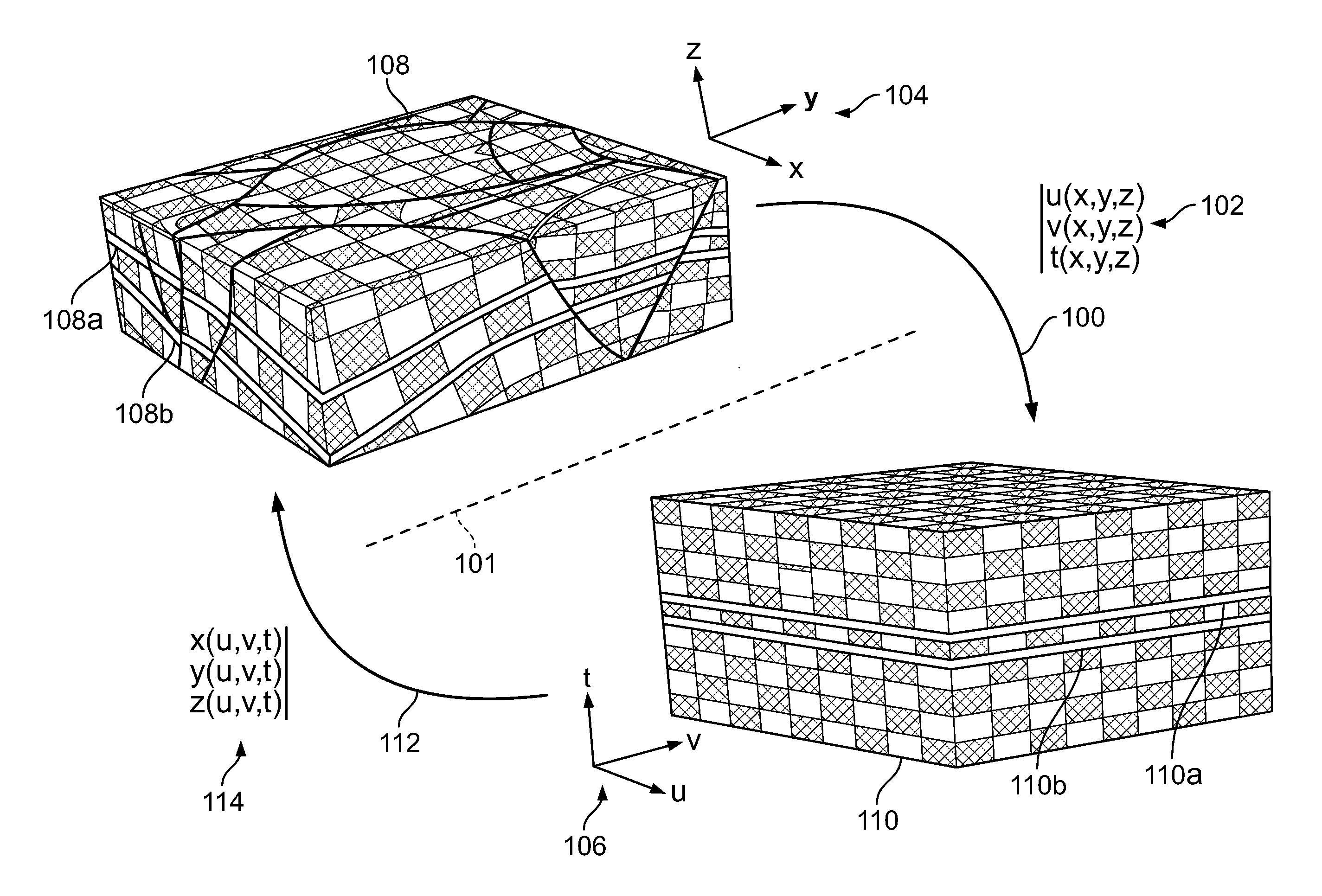
[0029]For the sake of clarity and for the purpose of simplifying the presentation of embodiments of the invention, the following preliminary definitions are given, although other definitions may be used:

[0030]Geological-Time

[0031]A particle of sediment in a geological terrain may be observed at a location in the subsurface. The seismic data for the location may be collected from underground imaging to acquire seismic or well data, for example, by recording acoustic or other waves using transmitters and receivers. The location of the particle may be mathematically represented or modeled, e.g., by a vector, (x,y,z), in a three-dimensional (3D) space, such as the Cartesian coordinate system (of course, when modeling such particles, the position of many particles may be modeled together as for example using a cell). When modeled, a data structure such as a node or cell may represent particles. The time when the particle of sediment was originally deposited may be referred to as the “geo...


PUM


Abstract

A method and system for modeling a subsurface structure at a time when the structure was originally formed. A first model having non-planar horizons representing a current subsurface structure may be used to calculate a vector field based on the non-planar geometry of the horizons of the model. The vector field may be non-uniform or uniform. Geographic coordinates of the first model may be transformed to paleo-geographic coordinates of a model representing the subsurface structure in the past, where the non-planar horizons in the first model are transformed to planar horizons in the second model. A set of points describing one or more fractures in the subsurface structure may be used to calculate a tuning parameter to correct a first set of paleo-geographic coordinates. A second set of coordinates representing an improved prediction at a time period when the subsurface structure was originally formed may be generated.

Description

CROSS-REFERENCE TO RELATED APPLICATIONS[0001]This application is a continuation-in-part of U.S. patent application Ser. No. 12 / 791,352, filed Jun. 1, 2010, which in turn claims the benefit of prior U.S. Provisional Application Ser. No. 61 / 182,813, filed Jun. 1, 2009, both of which are incorporated by reference herein in their entirety.FIELD OF THE INVENTION[0002]The invention pertains to the general field of modeling stratified terrains in the subsurface.[0003]More precisely, new techniques are proposed to determine structural directions in the subsurface and use these directions to build a system of paleo-geographic coordinates, e.g. (u,v) at any location in a geological domain. The paleo-geographic coordinates (u,v) may be used to model the stratified terrains at the geological-time at which they were originally deposited within the Earth.BACKGROUND OF THE INVENTION[0004]Erosion and tectonic activity through geological-time transform an initially uniform stratified terrain compose...

Claims


Application Information

Patent Timeline
IPC IPC(8): G06F17/50
CPCG06F17/5009G01V1/325G01V2210/661G01V99/005G01V2210/64G01V2210/66G01V2210/74G06F17/16G06F30/20G06T17/05
Inventor MALLET, JEAN-LAURENT
Owner ASPEN PARADIGM HLDG LLC
Why Eureka
Try Eureka