Method for correcting the time delay in measuring agricultural yield

a technology of agricultural yield and time delay, applied in the field of time delay correction in measuring agricultural yield, can solve the problems of insufficient correction, difficult correction, and considerable time spent on correction, and achieve the effect of facilitating the later comparison of data measured

Inactive Publication Date: 2014-05-08
GEOSYS
View PDF0 Cites 40 Cited by
  • Summary
  • Abstract
  • Description
  • Claims
  • Application Information

AI Technical Summary

Benefits of technology

[0032]Preferentially, the normal measuring points are projected onto a regular-mesh grid, the associated data being interpolated by linear regression. In this way, the measuring points are associated with meshes with the same area, which facilitates the later comparison of data measured.

Problems solved by technology

However, this data includes errors related to various phenomena, for example maneuvers carried out during harvesting, of which there are various sources:the combine harvester is completely full,the combine harvester is stationed to empty its load of grain,the combine harvester rotates at the end of the row,the farming plot is sloping,the weather changes the weight of grain observed,the imprecision of the cutting width used,the time lag,the loss of GPS signal,the blockages and / or loss of grain in the combine harvester,the precision of the sensors.
Some of these errors are known, but correcting them remains difficult.
In the current state of the art, these corrections are inadequate, and a farming producer who manages a farming plot in precision farming must correct the yield map supplied by the cartography software that he uses, based on his own knowledge of the farming plot.
The time spent achieving this correction is considerable, and the result still includes errors.
Moreover, this data calculated from instantaneous yield, being in the current state of the art and of the market, directly assimilated to yield data, the final map cannot show the variability of the yield in a very true way.

Method used


Image

  • Method for correcting the time delay in measuring agricultural yield
  • Method for correcting the time delay in measuring agricultural yield
  • Method for correcting the time delay in measuring agricultural yield

Examples


Embodiment Construction

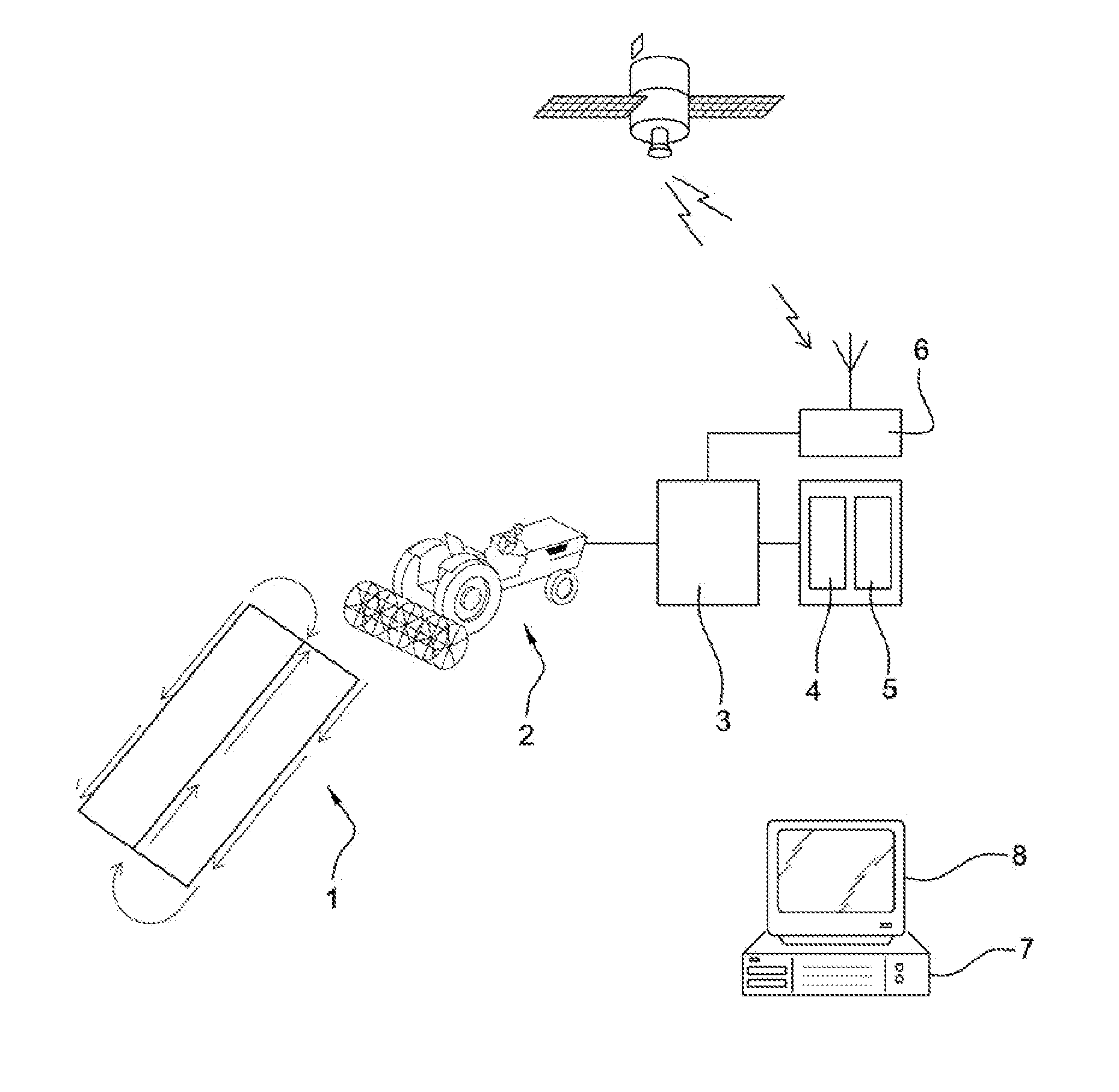
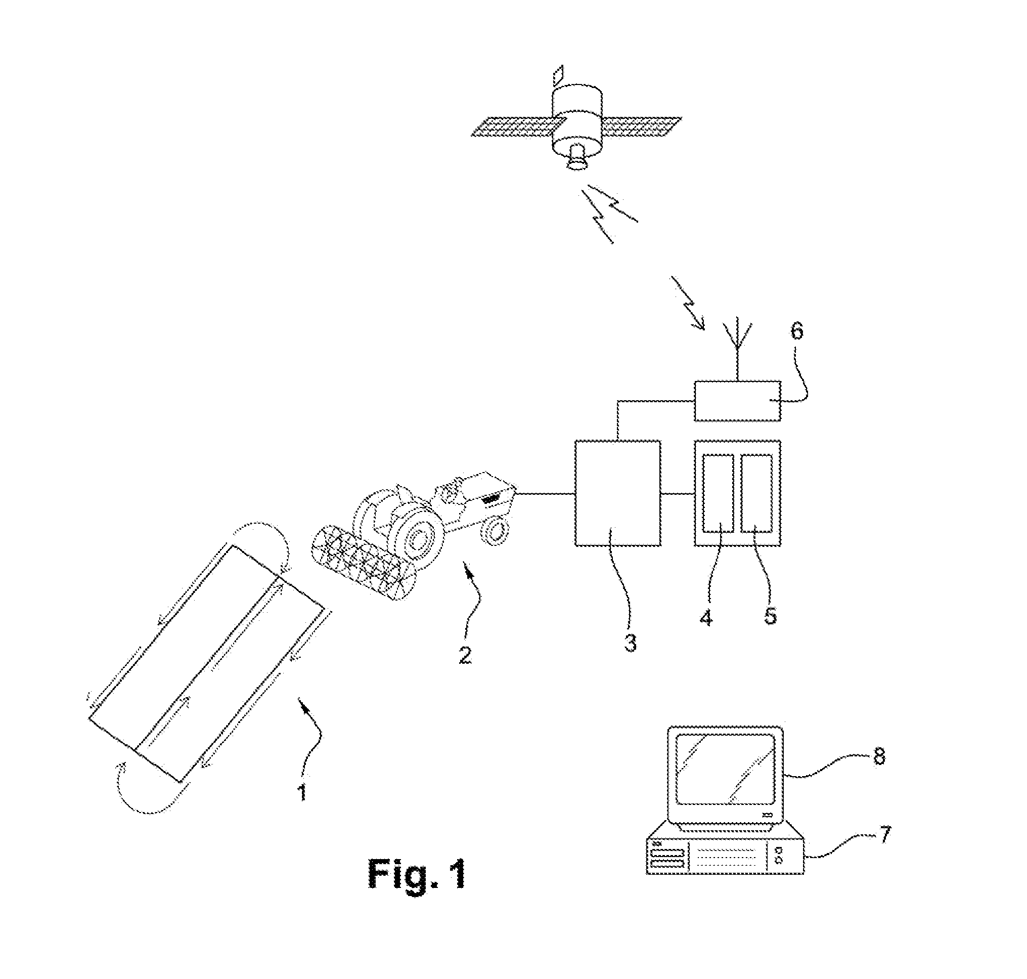
[0059]The invention finds its place in the context of a farm. The case of a farmer is considered, who needs a yield map in order to optimize the management of a farming plot.

[0060]This farmer uses, to cultivate his plot of land 1, a farming machine 2, which is, in the present example, no way exhaustive, a combine harvester. Conventionally, the combine harvester 2 sweeps along the plot of land 1 according to a preferential path, with half-turns at each end of said plot of land 1.

[0061]This combine harvester 2 is equipped here with a device 3 for taking measurements, connected to a set of sensors which includes, for example, a grain flow sensor 4 and a moisture sensor 5. The combine harvester 2 includes, moreover, a global positioning system 6, for example, GPS, also connected to the device for taking measurements 3.

[0062]This device for taking measurements 3 is used for acquiring data from the sensors 4, 5 and from the positioning system 6 at regular intervals, for example, every sec...


PUM

PropertyMeasurementUnit
time lagsaaaaaaaaaa
timeaaaaaaaaaa
timeaaaaaaaaaa

Abstract

A method of processing a set of data collected by at least one sensor at successive points on the travel over a plot of land by at least one vehicle. Each piece of the data being recorded with a time lag in relation to the vehicle passing a given point on the plot of the land, and being associated with a recording time and with a geographical position of a measuring point supplied by a geolocation system. An optimum difference value is estimated by minimizing a degree of projection of a three-dimensional map of values measured at each geographical point, and correction of the data being measured from this difference.

Description

[0001]The present invention relates to the area of farming, and more specifically to precision farming. It relates more precisely to a method of correcting time difference in measurements, preferentially measurements of flows of grain, and creating yield maps reflecting reality.BACKGROUND OF THE INVENTION[0002]In farming, the various products provided for the land and crops are called “inputs”. These products can be, for example, a seed, a fertilizer, a pesticide or irrigation water. In a same farming plot, the inputting needs differ geographically, for example according to the exposure of each area, or according to the local slope etc.[0003]In conventional farming, the provision of inputs on a farming plot is made without taking into account the variabilities inside this plot. On the other hand, precision farming consists of taking into account the variability inside a farming plot, in such a way as to optimize the quantity of inputs applied. It is understood therefore that the qua...

Claims


Application Information

Patent Timeline
Patent Type & Authority Applications(United States)
IPC IPC(8): G06Q50/02G01N33/00
CPCG01N33/0098G06Q50/02A01B79/005A01D41/1271
Inventor ROMIER, CHLOE
Owner GEOSYS
Why Eureka
Try Eureka