Aerial image collection

a technology for aerial vehicles and images, applied in vehicle positions/courses/altitude control, process and machine control, instruments, etc., can solve the problems of large buildings that cannot be adequately photographed from vehicle-mounted cameras, road signs, and other obstacles that may occlude building facades from the view of vehicle-mounted cameras,

Active Publication Date: 2014-09-11
HERE GLOBAL BV
View PDF7 Cites 106 Cited by
  • Summary
  • Abstract
  • Description
  • Claims
  • Application Information

AI Technical Summary

Problems solved by technology

However, larger buildings cannot be adequately imaged from vehicle-mounted cameras.
Also, vegetation, road signs, or other obstacles may occlude building facades from the view of vehicle-mounted cameras.
Airplanes are also incapable of adequately collecting images of the sides of buildings because of the angle of the line of sight.
However, this technique is too labor intensive.
The imagery is limited

Method used


Image

  • Aerial image collection
  • Aerial image collection
  • Aerial image collection

Examples


Embodiment Construction

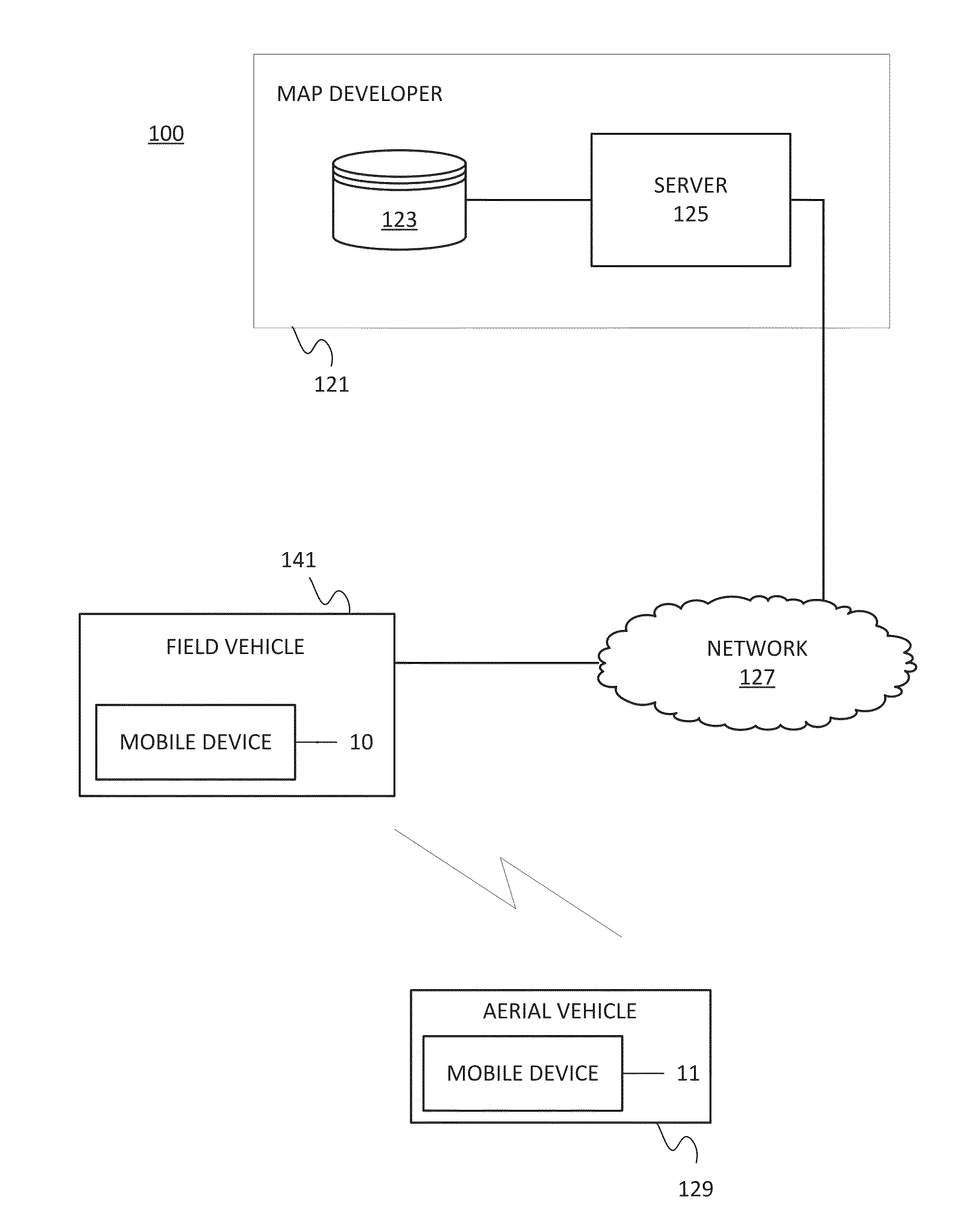
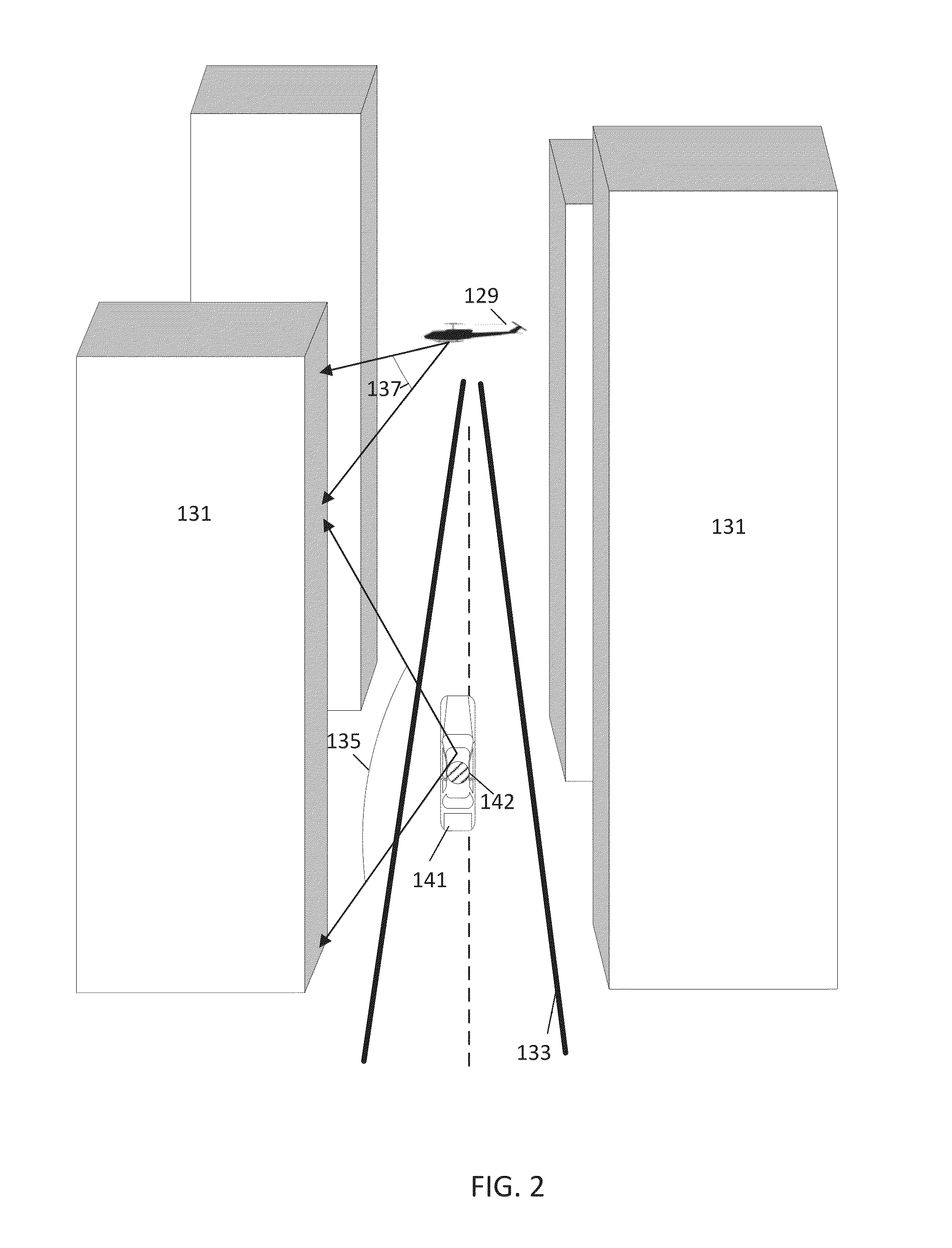
[0015]Street side imagery is collected by field vehicles equipped with cameras. The imagery is limited by the range of the cameras. For example, some portions of the building may be blocked by shrubs, trees, parked cars, people, or other objects between the field vehicle and the building facade. Also, high portions of the building facade may be out of range or out of the field of view of vehicle mounted cameras. An aerial vehicle may be used in cooperation with the field vehicle. The aerial vehicle may include a camera with a field of view that overlaps or otherwise supplements the camera in the vehicle. The aerial vehicle may track a field vehicle and follow the field vehicle. The image data collected by the aerial vehicle may be combined with the image data collected by the field vehicle. The aerial vehicle may be an autonomous vehicle such as an unmanned aerial vehicle (UAV). The aerial vehicle may be radio controlled helicopter (e.g., quadcopter or other helicopter).

[0016]The tr...


PUM


Abstract

In one embodiment, an aerial collection system includes an image collection field vehicle that travels at street level and an image collection aerial vehicle that travels in the air above the street. The aerial vehicle collects image data including at least a portion of the field vehicle. The field vehicle includes a marker, which is identified from the collected image data. The marker is analyzed to determine an operating characteristic of the aerial vehicle. In one example, the operating characteristic in the marker includes information for a flight instruction for the aerial vehicle. In another example, the operating characteristic in the marker includes information for the three dimensional relationship between the vehicles. The three dimensional relationship is used to combine images collected from the air and images collected from the street level.

Description

FIELD[0001]The following disclosure relates to image collection from an aerial vehicle, or more particularly, an analysis of a relationship between a field vehicle and image collection from an aerial vehicle.BACKGROUND[0002]Road level imagery may be collected using video cameras in a vehicle. Road level imagery provides adequate images of building facades around eye level or the level of the video cameras in the vehicle. However, larger buildings cannot be adequately imaged from vehicle-mounted cameras. Also, vegetation, road signs, or other obstacles may occlude building facades from the view of vehicle-mounted cameras.[0003]Aerial photography from satellites and airplanes provide another view. Satellites orbit hundreds of miles to thousands of miles above the surface of the Earth and can provide only low detail images of wide geographic areas. Airplanes fly a minimum of four hundred feet above the surface of the Earth and also provide relatively low detail images. Airplanes are al...

Claims


Application Information

Patent Timeline
IPC IPC(8): B64C19/00
CPCB64C19/00G01C11/06G05D1/0094G01C11/02B64U10/17B64U10/60B64U10/14B64U2101/30G06T17/00B64U10/10B64U2201/20B64C39/024G01C11/08G05D1/0022
Inventor TILLMANN, MARCO
Owner HERE GLOBAL BV
Why Eureka
Try Eureka