3D analytics actionable solution support system and apparatus

a technology of actionable solutions and support systems, applied in the direction of visual data mining, instruments, image generation, etc., can solve the problems of maximum utilization of investment, analysis and maintenance, and rarely unified data contained therein

Inactive Publication Date: 2017-04-20
SATKUNARAJAH THARMALINGAM +1
View PDF1 Cites 36 Cited by
  • Summary
  • Abstract
  • Description
  • Claims
  • Application Information

AI Technical Summary

Benefits of technology

[0010]These and other aspects, features and advantages of the present invention can be further appreciated from the following discussion of certain more particular embodiments thereof.

Problems solved by technology

Although there are many types of spatial and non-spatial data held by different organizations, agencies, and private companies, the data contained therein is rarely unified or in compatible formats.
The disparate nature of the data repositories, formats and structures prevent the maximum utilization of the investment in the data capture, initial analysis and maintenance.

Method used


Image

  • 3D analytics actionable solution support system and apparatus
  • 3D analytics actionable solution support system and apparatus
  • 3D analytics actionable solution support system and apparatus

Examples


Embodiment Construction

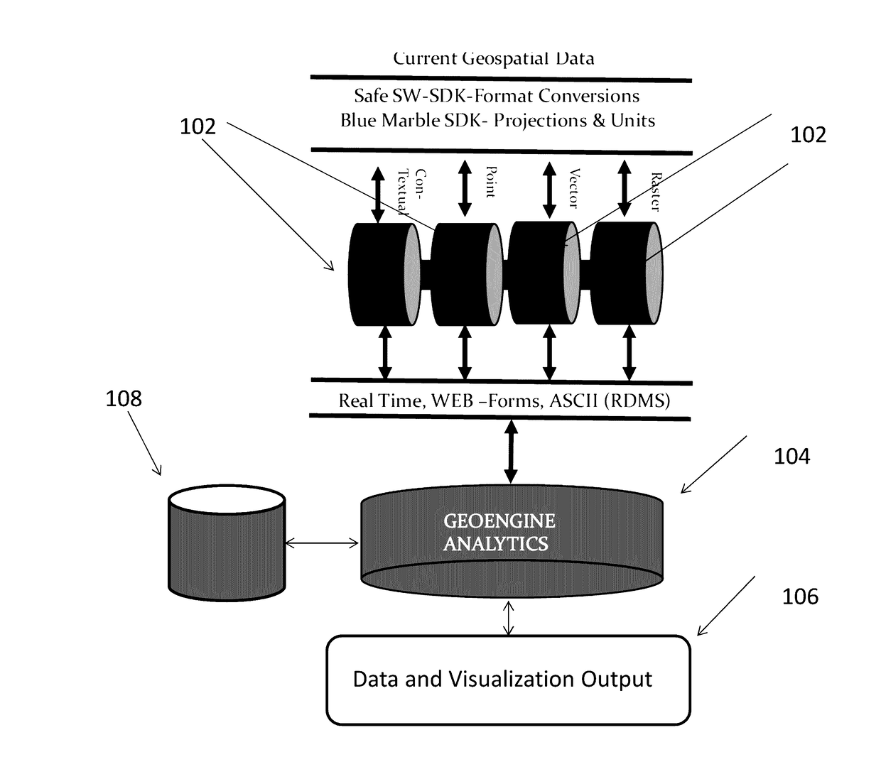
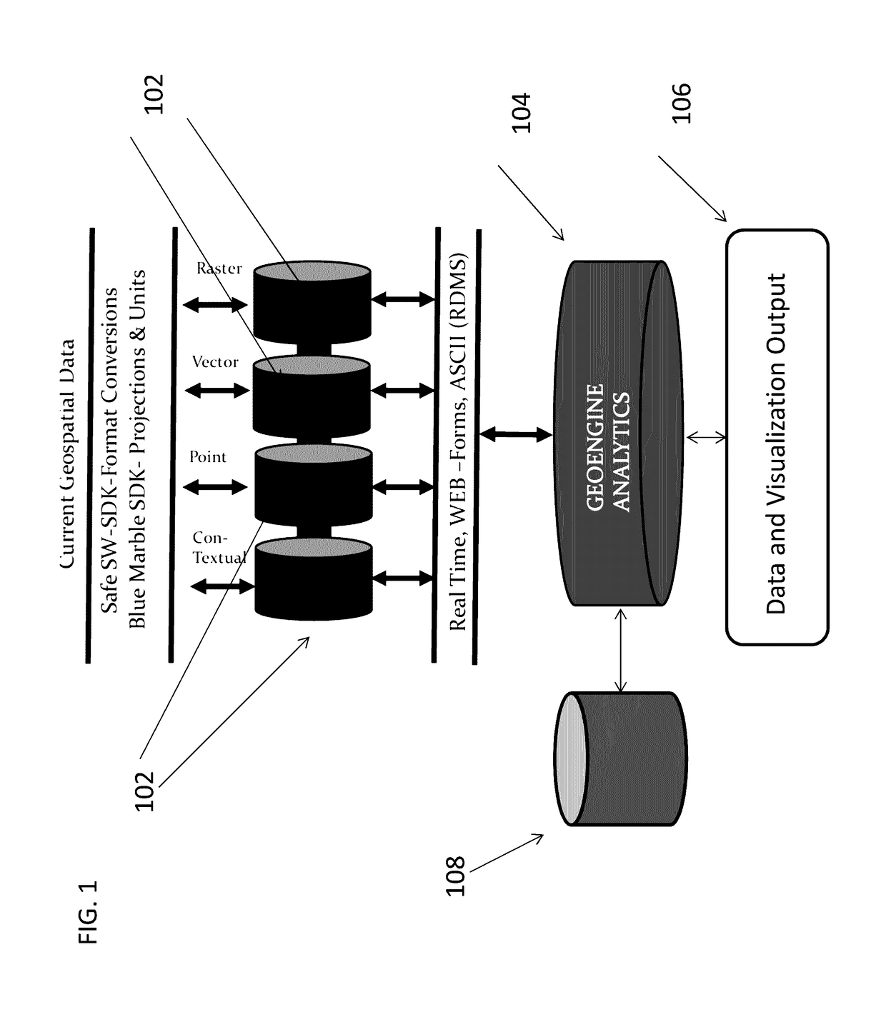
[0017]By way of overview and introduction, the present invention concerns a system and method for accessing, transforming and visualizing spatial and non-spatial data related to a geographic location and providing such a transformations and visualizations to a remote computing device, such as a smart phone, virtual reality interface (VR), augmented reality (AR) interface device, or autonomous or semiautonomous device.

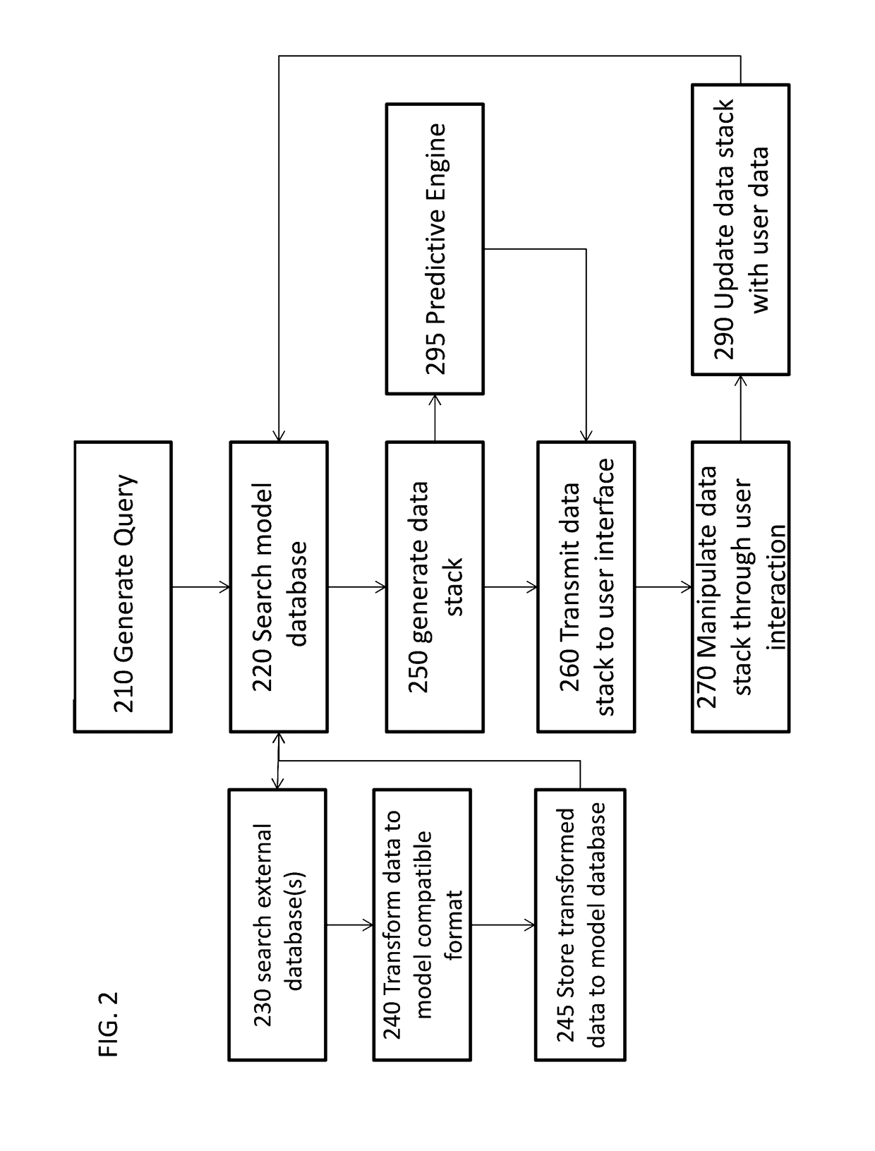
[0018]Specifically, the present system and method are directed to running queries in a data object database for a geographic location and receiving a customized data package that combines available geospatial data, contextual data, metadata and predictive data that provides a custom solution to the user query. Such a data stack, when implemented in a 3D environment is used to provide actionable information to entities in the Transportation, Water, Environmental, Engineering, Telecommunication, Finance, Energy, Natural Resources, Defense, Insurance, Retail, City planning...


PUM


Abstract

The claimed invention relates to a system and method for generating actionable intelligence and information by utilizing a multi-sensor, multi-temporal; multi-spatial, multi-format data (mSTSFA) architecture stored in a NoSQL data architecture to qualify spatial (accuracy) and contextual information integrated into a real time Engineering Grade location based analysis and predictive analytics engine returning users based queries in a 3D visualization including Virtual Reality (VR)/Augmented Reality functionality. The present invention is a systemized platform for handling geospatial, geophysical, financial, temporal and attribute data input directly to analyze the datasets to serve the operational and business needs of the industries such as transportation, water, environmental, engineering, telecommunication, finance, energy, natural resources, defense and security.

Description

1. CROSS-REFERENCE TO RELATED APPLICATIONS[0001]This application claims priority to U.S. provisional application Ser. No. 62 / 241,394, filed Oct. 14, 2015, which is hereby incorporated by reference in its entirety.2. INTRODUCTION[0002]The present invention describes an apparatus and method for integrating multi-sensor, multi-temporal, multi-spatial, multi-format data from multiple sensors or data stores in a real-time engineering grade location based analysis and predictive analytic 3D data stack and visualizing that data in real-time in response to user inquires.3. BACKGROUND[0003]Although there are many types of spatial and non-spatial data held by different organizations, agencies, and private companies, the data contained therein is rarely unified or in compatible formats. The disparate nature of the data repositories, formats and structures prevent the maximum utilization of the investment in the data capture, initial analysis and maintenance. Thus, there exists a need therefore...

Claims


Application Information

Patent Timeline
Patent Type & Authority Applications(United States)
IPC IPC(8): G06F17/30G06T17/05
CPCG06F17/30572G06F17/30241G06T17/05G06F17/30569G06F17/30575G06F17/30554G06T17/00G06T2210/04G06T2210/56G06F16/26G06F16/29G06F16/258G06F18/2155G06F16/27G06F16/248
Inventor SATKUNARAJAH, THARMALINGAMSATHASIVAM, KALAYINI
Owner SATKUNARAJAH THARMALINGAM
Why Eureka
Try Eureka