Method and system for a plurality of mobile units to locate one another

Inactive Publication Date: 2005-03-15
TRIMBLE NAVIGATION LTD
View PDF16 Cites 462 Cited by
  • Summary
  • Abstract
  • Description
  • Claims
  • Application Information

AI Technical Summary

Problems solved by technology

The vehicle locating system described above, while useful for tracking the fleet of a trucking company or a moving company, is limited in that the positions of the vehicles

Method used


Image

  • Method and system for a plurality of mobile units to locate one another
  • Method and system for a plurality of mobile units to locate one another
  • Method and system for a plurality of mobile units to locate one another

Examples


Embodiment Construction

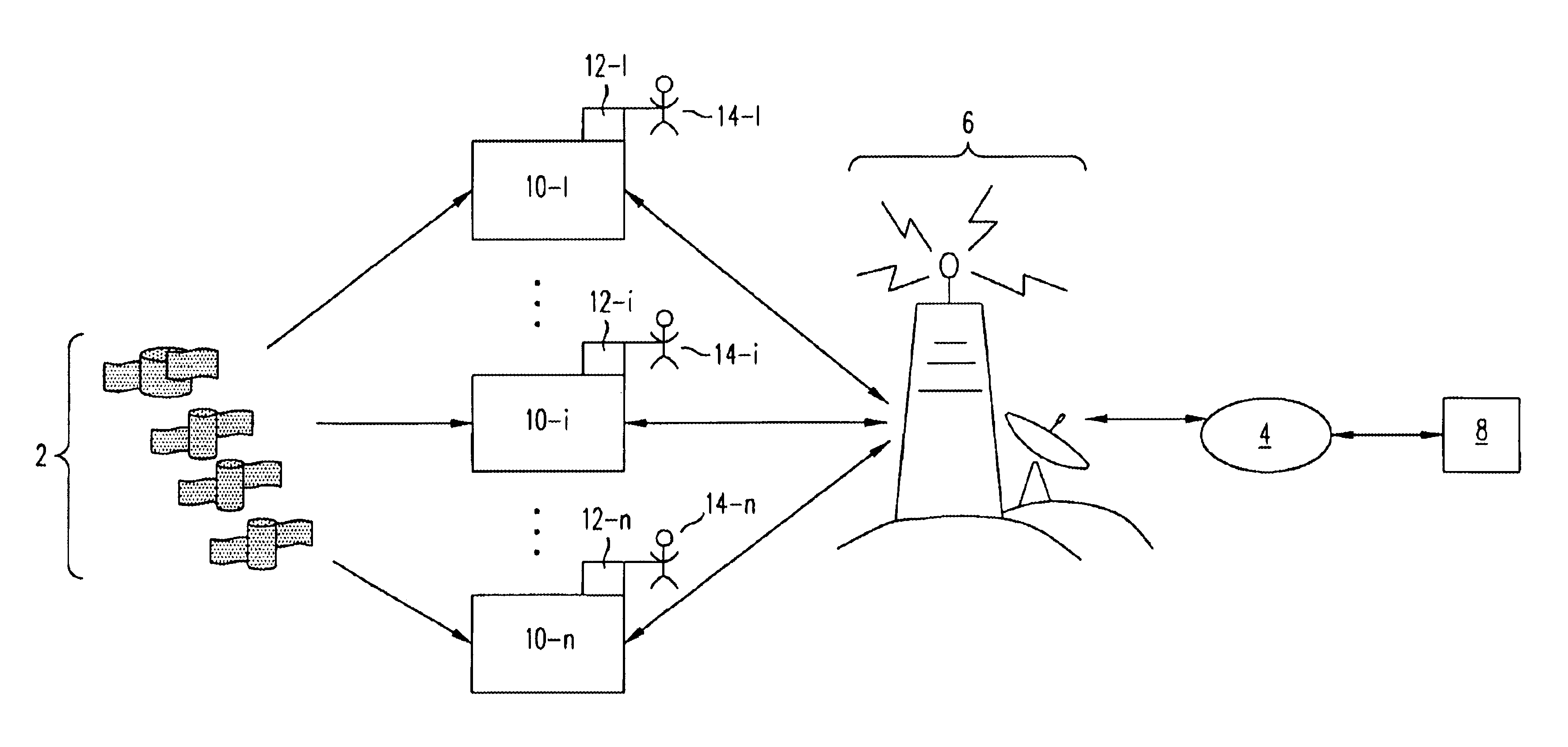
FIG. 1 provides an overview of the location-specific peer-to-peer communication system in accordance with the present invention. The system includes GPS satellites 2, data network 4, server 6, communication network 6, service provider 8, and mobile units 10-1 through 10-n where n is the total number of mobile units in the system. Mobile units 10-1 through 10-n are connected to user interface device 12-1 through 12-n, respectively. Users 14-1 through 14-n transmit information to and receive information from mobile units 10-1 through 10-n through user interface device 12-1 through 12-n, respectively.

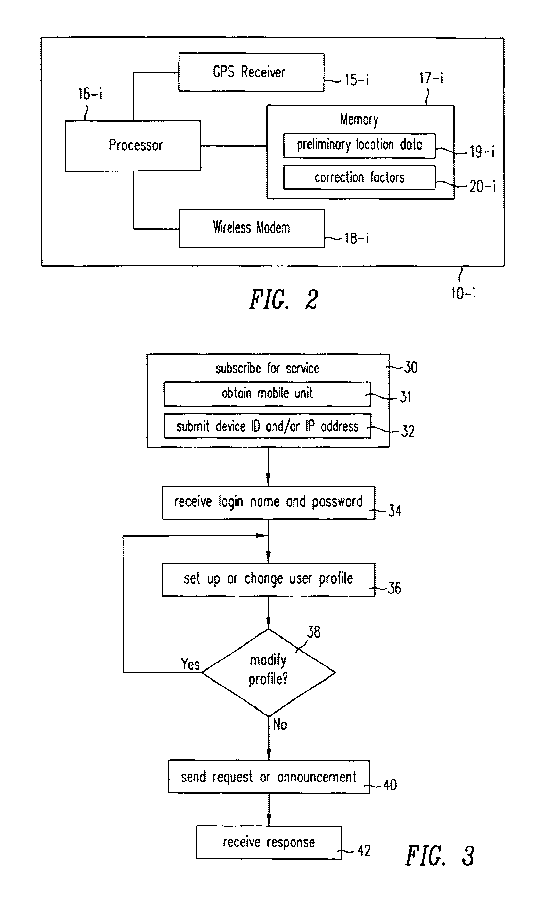
As used herein, mobile unit 10-i refers to one mobile unit of mobile units 10-1 through 10-n and user interface device 12-i refers to the user interface device that is connected to mobile unit 10-i. Mobile units 10-1 through 10-n receive code sequences from GPS satellites 2 and convert the code sequences to location data. In addition, mobile units 10-1 through 10-n receive information from...


PUM


Abstract

A method and system whereby two mobile units can locate each other is presented. A user connects an interface device, such as a personal digital assistance (PDA), a wireless phone, a laptop, or a pager, to a mobile unit. The mobile unit regularly obtains its location through a location-determining technology (e.g., GPS) and sends the location to a service provider computer. The service provider computer maintains a database of the current location of all the mobile units, and provides the location of mobile units to each of the mobile units. The mobile unit communicates with the service provider wirelessly through a communication network and a data network, for example the Internet.
A user of the mobile unit can send messages to other users with a location stamp, which indicates the location of the message sender's mobile unit. In addition, a user can send a request to be notified when a target mobile unit reaches a reference point. The reference point may be defined relative to the location of the requester. Alternatively, the reference point may be an address or a landmark. Upon receiving the request, the service provider computer tracks the distance between the target mobile unit and the reference point, and sends a notification to the requester when the target mobile unit reaches the reference point.

Description

BACKGROUND1. Field of the InventionThe invention relates to a system and a method for distributing positional information and location specific messages to mobile units by using a data network.2. Description of the Related ArtGlobal positioning system (“GPS”) is used for obtaining position information. The GPS includes a plurality of satellites orbiting the earth and sending out, at precisely synchronized times, a code sequence that identifies the satellite. Specifically, the code sequence transmitted by each satellite is a precisely timed binary pulse train. In addition to the code sequence, these satellites send out positioning information that can be used to calculate vehicle positions. A GPS receiver retrieves the positioning information from the GPS satellites and triangulates the information to obtain the position of the receiver. A more detailed discussion of a GPS receiver is found in U.S. Pat. No. 5,990,827 to Rodric C. Fan, et al. entitled “Structure of a Position Processi...

Claims


Application Information

Patent Timeline
IPC IPC(8): G08G1/123G01S5/02G01S5/00G01S5/14G01S19/02G01S19/27
CPCG01S5/0072G08G1/20G01S5/0027G01S19/48G01S19/51G01S19/40
Inventor SANDHU, KULBIR S.FAN, RODERIC C.MLECZKO, DAVIDNGUYEN, KENNYFAN, CAREY
Owner TRIMBLE NAVIGATION LTD
Why Eureka
Try Eureka