System and method of displaying position information including an image in a navigation system

a navigation system and position information technology, applied in surveying, navigation, navigation instruments, etc., can solve the problems of inability of conventional navigation systems to selectively provide information about user-desired nodes, mobile terminals' displaying position information received from gps devices on the map, and inability to help users to be aware of the surroundings of the area

Active Publication Date: 2008-06-03
QUALCOMM INC
View PDF11 Cites 43 Cited by
  • Summary
  • Abstract
  • Description
  • Claims
  • Application Information

AI Technical Summary

Benefits of technology

[0008]An object of the present invention is to substantially solve at least the above problems and disadvantages and to provide at least the advantages described below. Accordingly, an

Problems solved by technology

However, the conventional navigation system cannot selectively provide information about user-desired nodes.
Moreover, the mobile terminal's displ

Method used


Image

  • System and method of displaying position information including an image in a navigation system
  • System and method of displaying position information including an image in a navigation system
  • System and method of displaying position information including an image in a navigation system

Examples


Embodiment Construction

[0040]Embodiments of the present invention will be described herein below with reference to the accompanying drawings. In the following description, well-known functions or constructions are not described in detail for conciseness.

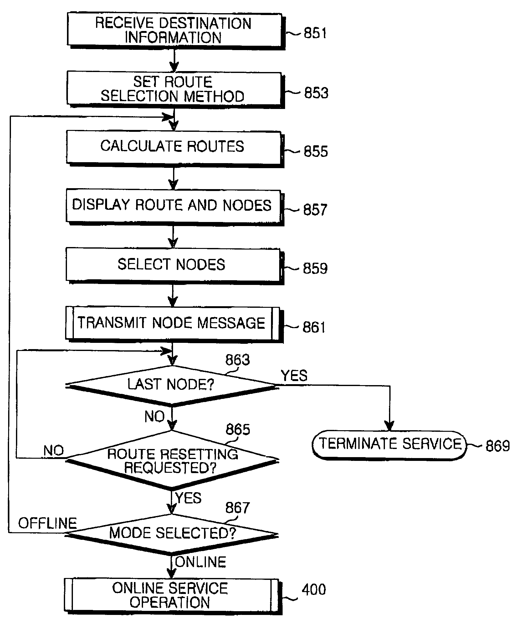
[0041]In a navigation system according to the present invention, a mobile terminal displays virtual reality (VR)-images of predetermined nodes enroute to a destination when the mobile terminal moves to the nodes. The term node is used to refer to a location or anything along a predetermined route from a starting point to a destination. From the images as well as map data, thus, the user of the mobile terminal can be fully aware of the nodes to be visited.

[0042]Since it is troublesome to download image information about all the nodes enroute to a destination and reproduce the image information, the mobile terminal may download and display image information about some nodes of interest in advance prior to departure. Therefore, the user can be aware of the su...


PUM


Abstract

A system and method of displaying position information including an image in a navigation system are disclosed. The navigation system has an information center and a mobile terminal. The information center includes a database for storing a node message with node image information about the geographical features of a node and a database for storing map data. The node image information is divided into image segments corresponding to directions. The information center sets a route according to a current position and a destination of the mobile terminal, generates map data including the route and nodes in the route, and transmits it to the mobile terminal. The mobile terminal selects nodes for which to receive node messages in the map data. The information center transmits a node message for the next node each time the mobile terminal reaches each of the selected nodes. The mobile terminal reproduces the node message.

Description

PRIORITY[0001]This application claims the benefit under 35 U.S.C. § 119(a) of an application entitled “Method of Displaying Position Information Including Image in a Navigation System” filed in the Korean Intellectual Property Office on Jun. 3, 2003 and assigned Serial No. 2003-35744, and of an application entitled “Method of Displaying Position Information Including Image in a Navigation System” filed in the Korean Intellectual Property Office on Jun. 3, 2003 and assigned Serial No. 2003-35750, the entire content of both of which are incorporated herein by reference.BACKGROUND OF THE INVENTION[0002]1. Field of the Invention[0003]The present invention relates to a position displaying system and method in a navigation system. In particular, the present invention relates to a system and method of displaying information about a predetermined node including an image of the node during moving.[0004]2. Description of the Related Art[0005]A Global Positioning System (GPS) enabled mobile te...

Claims


Application Information

Patent Timeline
IPC IPC(8): G01C21/26G01C21/36
CPCG01C21/36G01C21/3647
Inventor PARK, YOUNG-SIK
Owner QUALCOMM INC
Why Eureka
Try Eureka