Transprojection of geometry data

a technology of geometry data and projection capability, applied in the direction of distance measurement, image enhancement, instruments, etc., can solve the problems of insufficient flexibility of projection capability to model 3d coordinate data in combination with 2d, difficulty, and insufficient ability to superimpose or transproject scaled 3d geometry, etc., to achieve accurate rendering

Inactive Publication Date: 2010-04-06
HEXAGON METROLOGY INC
View PDF97 Cites 200 Cited by
  • Summary
  • Abstract
  • Description
  • Claims
  • Application Information

AI Technical Summary

Benefits of technology

[0011]In certain embodiments, calibration of the camera with respect to the target area is accomplished through the application of empirical correction factors to the coordinate data that model various camera characteristics including, for example: angle, focal length, distortion, offset / scaling, and camera position. Use of these corrections factors provides a means to scale the coordinate data to the digital images by establishing a coordinate system in which both the digital image data and the probe coordinate data may be accurately rendered.

Problems solved by technology

One limitation found in many conventional instruments is that they are generally intended to operate in an environment wherein geometry information captured by the probe or remote scanning device forms an electronic representation of the object without the benefit of photographic dimensional details scaled to the same coordinate system as the geometry information.
These apparatuses are generally directed towards systems for remotely monitoring a probe contact region and surrounding area in a two dimensional context and fail to adequately provide the ability to superimpose or transproject scaled 3D geometry or coordinate data upon 2D images that can be made to accurately reflect the various object details in different orientations and rotations.
However desirable, accurate coupling of digital object image information to coordinate data presents a number of difficulties in order to capture the characteristics and benefits of each in combination.
In these and other regards, conventional instruments and methods fail to adequately provide flexible transprojection capabilities to model 3D coordinate data in combination with 2D photographic images.

Method used


Image

  • Transprojection of geometry data
  • Transprojection of geometry data
  • Transprojection of geometry data

Examples


Embodiment Construction

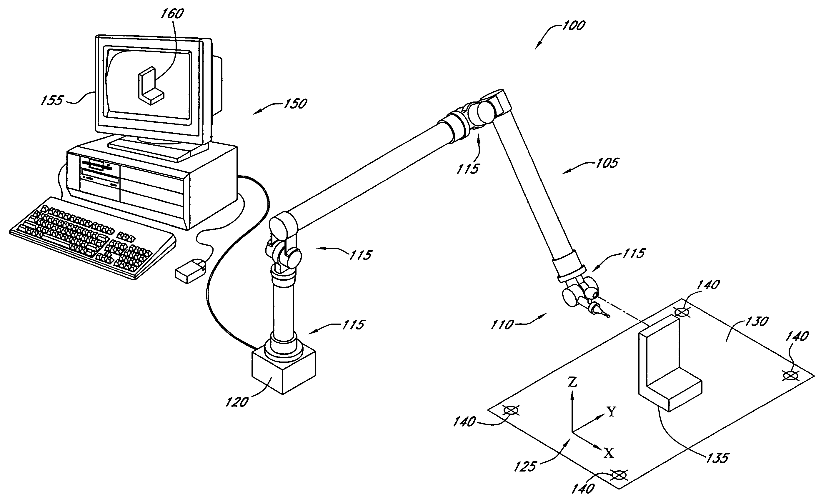
[0031]The following detailed description presents various descriptions of certain embodiments of the present teachings described herein. However, the inventive scope of the present teachings can be embodied in a multiplicity of different ways as defined and covered by the claims. In this description, reference is made to the drawings wherein like parts are designated with like numerals throughout.

[0032]In the description, the term transprojection generally defines the process of associating coordinate or geometry data with image data or information. In one aspect, the coordinate data is based on a 3D coordinate system and the image data is based on a 2D coordinate system, alternatively, both the coordinate data and the image data may be 3D in nature and utilize the same or different coordinate systems. In still other embodiments, both the coordinate data and the image data may be based on 2D coordinate systems.

[0033]The transprojection processes define a means by which to merge or a...


PUM


Abstract

A system and methods for transprojection of geometry data acquired by a coordinate measuring machine (CMM). The CMM acquires geometry data corresponding to 3D coordinate measurements collected by a measuring probe that are transformed into scaled 2D data that is transprojected upon various digital object image views captured by a camera. The transprojection process can utilize stored image and coordinate information or perform live transprojection viewing capabilities in both still image and video modes.

Description

RELATED APPLICATIONS[0001]This application incorporates by reference in its entirety the following co-pending application Ser. No. 10 / 758,697 entitled “AUTOMATED ROBOTIC MEASURING SYSTEM”.BACKGROUND[0002]1. Field of the Invention[0003]The present teachings generally relate to rectilinear measuring systems and articulated arm coordinate measuring machines and more particularly to a system and methods for transprojecting geometry data.[0004]2. Description of the Related Art[0005]Rectilinear measuring systems, also referred to as coordinate measuring machines (CMM's) and articulated arm measuring machines including portable coordinate measuring machines (PCMM's) have been described for generating geometry information from various objects and areas. In general, these devices capture the structural characteristics of an object for use in electronic rendering and duplication. One example of a conventional apparatus used for coordinate data acquisition comprises a support and a moveable ar...

Claims


Application Information

Patent Timeline
Patent Type & Authority Patents(United States)
IPC IPC(8): G06K9/00G01B11/26G01B5/004G06T15/00G01C3/14G01B21/04G06T7/00
CPCG01B21/04G06T7/0042G06T11/60G06T2207/20221G06T7/73G01B9/0203G01B9/02029G01B21/02G01B9/0205G01B9/02023G01B9/02031
Inventor PULLA, SANDEEPEATON, HOMER
Owner HEXAGON METROLOGY INC
Why Eureka
Try Eureka