Methods and apparatus for geo-collaboration

a technology of geo-collaboration and methods, applied in the field of methods and apparatus for collaborative use of geographical information, can solve the problems of limited collaboration software applications, hand-held information, and large volume of information, and achieve the effects of reducing the number of hands, and improving the accuracy of the work

Active Publication Date: 2010-06-15
VID SCALE INC
View PDF6 Cites 28 Cited by
  • Summary
  • Abstract
  • Description
  • Claims
  • Application Information

AI Technical Summary

Benefits of technology

[0007]Among its several aspects, the present invention addresses problems such as those described above and brings together the core functions of collaborative software applications with those of GIS to provide a collaborative framework based on maps and location. Another aspect of the present invention provides computer users with the ability to share, independently of their respective location, maps and geospatial information overlaid on maps. Another aspect of the present invention, called decentralized data updating in synchronous and asynchronous modes, provides users with the ability to work with geospatial information while connected or disconnected from other collaborators. Another aspect of the present invention, called asymmetrical information management, provides users with the ability to choose to share all or portions of their own geospatial information with other users.

Problems solved by technology

Typically, collaborative software applications are limited to allowing users to jointly edit a document, a presentation, a spreadsheet, or other flat file.
Computerized maps, on the other hand, may contain voluminous and complex information.
As noted in “IT Roadmap to a GeoSpatial Future,” The National Academies Press, 2003, many problems in combining GIS with collaborative software applications have been identified.
This book recognizes that “there has been no attention to how the new collaborative features might be integrated with geospatial analysis activities and only limited attention to the role of interactive visualizations in facilitating cooperative work.” Furthermore, this work recognizes that the volume and complexity of the geospatial information will make it increasingly hard to use effectively.
This book recognizes that many research efforts have centered on the creation of virtual spaces but have not determined how to enable navigation through virtual spaces in a collaborative manner.

Method used


Image

  • Methods and apparatus for geo-collaboration
  • Methods and apparatus for geo-collaboration
  • Methods and apparatus for geo-collaboration

Examples


Embodiment Construction

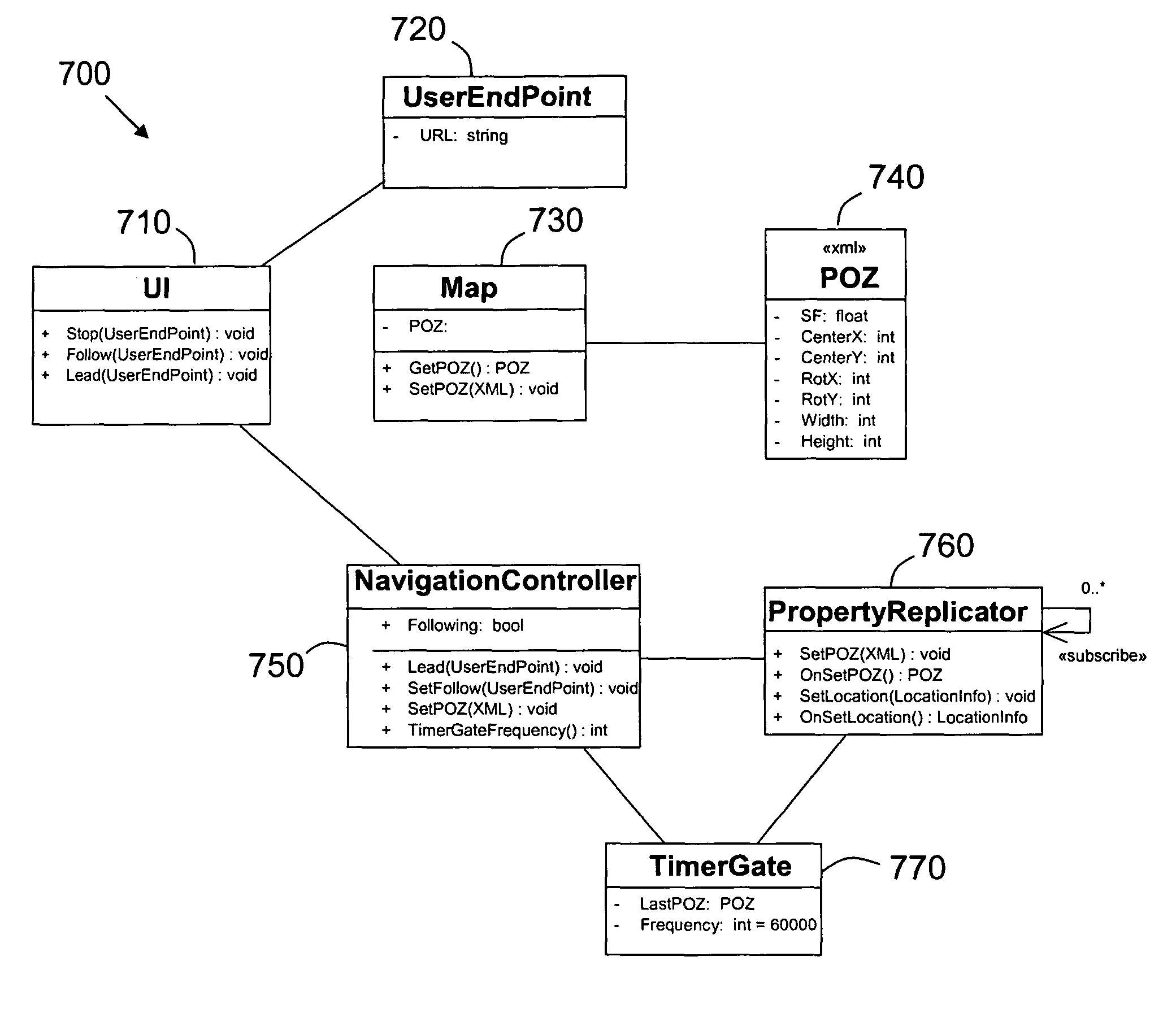
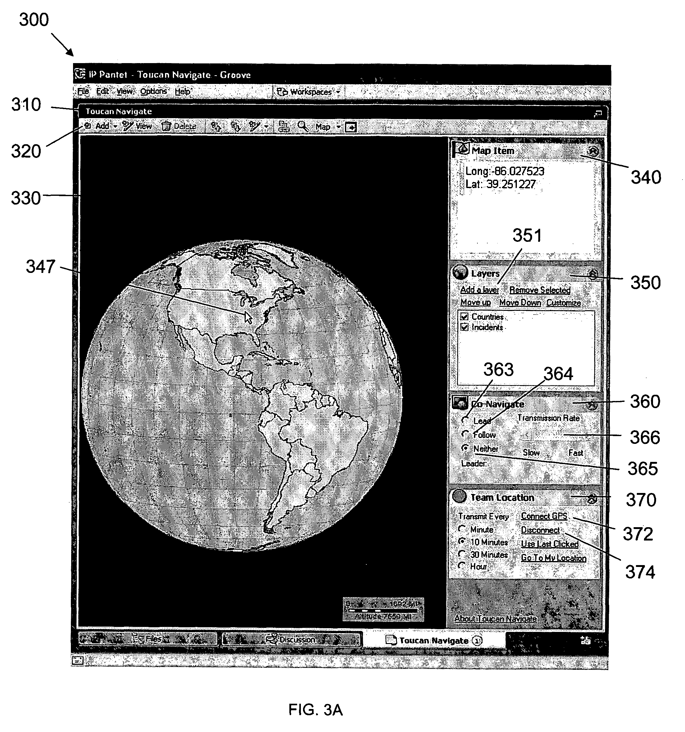
[0035]The present invention will now be described more fully with reference to the accompanying drawings, in which several presently preferred embodiments of the invention are shown. This invention may, however, be embodied in various forms and should not be construed as limited to the embodiments set forth herein. Rather, these embodiments are provided so that this disclosure will be thorough and complete, and will fully convey the scope of the invention to those skilled in the art.

[0036]As will be appreciated by one of skill in the art, the present invention may be embodied as methods, systems, or computer program products. Accordingly, the present invention may take the form of a hardware embodiment, a software embodiment or an embodiment combining software and hardware aspects. Furthermore, the present invention may take the form of a computer program product on a computer-usable storage medium having computer-usable program code embodied in the medium. Any suitable computer rea...


PUM


Abstract

Methods and computer readable medium for collaborating on geographical maps between two or more computers are disclosed. In particular, sharing a geographical location on a map between two or more computers and co-navigating a map between two or more computers are disclosed. With respect to sharing a geographical location, the geographical location is retrieved to the first computer. The geographical location is added to the map being rendered at the first computer and is sent to a second computer. A map including the geographical location is rendered at the second computer. With respect to co-navigating, a map is displayed from a map perspective at the first computer. The map perspective is sent to the second computer. A map from the same map perspective being displayed at the first computer is rendered at the second computer.

Description

[0001]This application claims the benefit of U.S. Provisional Application Ser. No. 60 / 636,953 filed on Dec. 17, 2004 entitled “Geo-Collaboration System”, which is incorporated by reference herein in its entirety.FIELD OF THE INVENTION[0002]The present invention relates generally to methods and apparatus for collaborative usage of geographical information, and more particularly, to advantageous techniques for combining geographical information systems with collaborative systems to achieve advantageous map features between users of two or more computers.BACKGROUND OF THE INVENTION[0003]Geographical information systems (GIS), computerized mapping systems that enable a user to visualize geographical information such as topographical, natural or man made borders, rivers, lakes, and the like have been around for many years. A computerized map file, such as Environmental Systems Research Institute's (ESRI) geodatabase file format, comprises one or more layers of geographical information wh...

Claims


Application Information

Patent Timeline
Patent Type & Authority Patents(United States)
IPC IPC(8): G01C21/32
CPCG09B29/10H04W4/023H04L67/52H04L51/222H04L67/01H04L67/10H04W64/00
Inventor COCH, GABRIELSMITH, DAVID MARKKNIGHT, GRAHAM
Owner VID SCALE INC
Why Eureka
Try Eureka