AI technical title is built by PatSnap AI team. It summarizes the technical point description of the patent document.
a digital mapping and second map technology, applied in the field of digital mapping systems, can solve the problems that the area outside the zoomed area cannot be scened or otherwise referenced by the user, and limit the amount of flexibility available to the user
Active Publication Date: 2011-01-04
GOOGLE LLC
View PDF86 Cites 46 Cited by
Summary
Abstract
Description
Claims
Application Information
AI Technical Summary
This helps you quickly interpret patents by identifying the three key elements:
Problems solved by technology
Method used
Benefits of technology
Problems solved by technology
Thus, when a user is zoomed on a particular map area, areas outside that zoomed area cannot be scene or otherwise referenced by the user.
However, if the user does not know which direction to pan, then the user will have to zoom out first, until the desired map area is in view, and then zoom back on that desired area.
In this sense, a single view map limits the amount of flexibility available to the user.
Method used
Image
Click on the blue label to locate the original text in one second.
Reading with bidirectional positioning of images and text.
Examples
Embodiment Construction
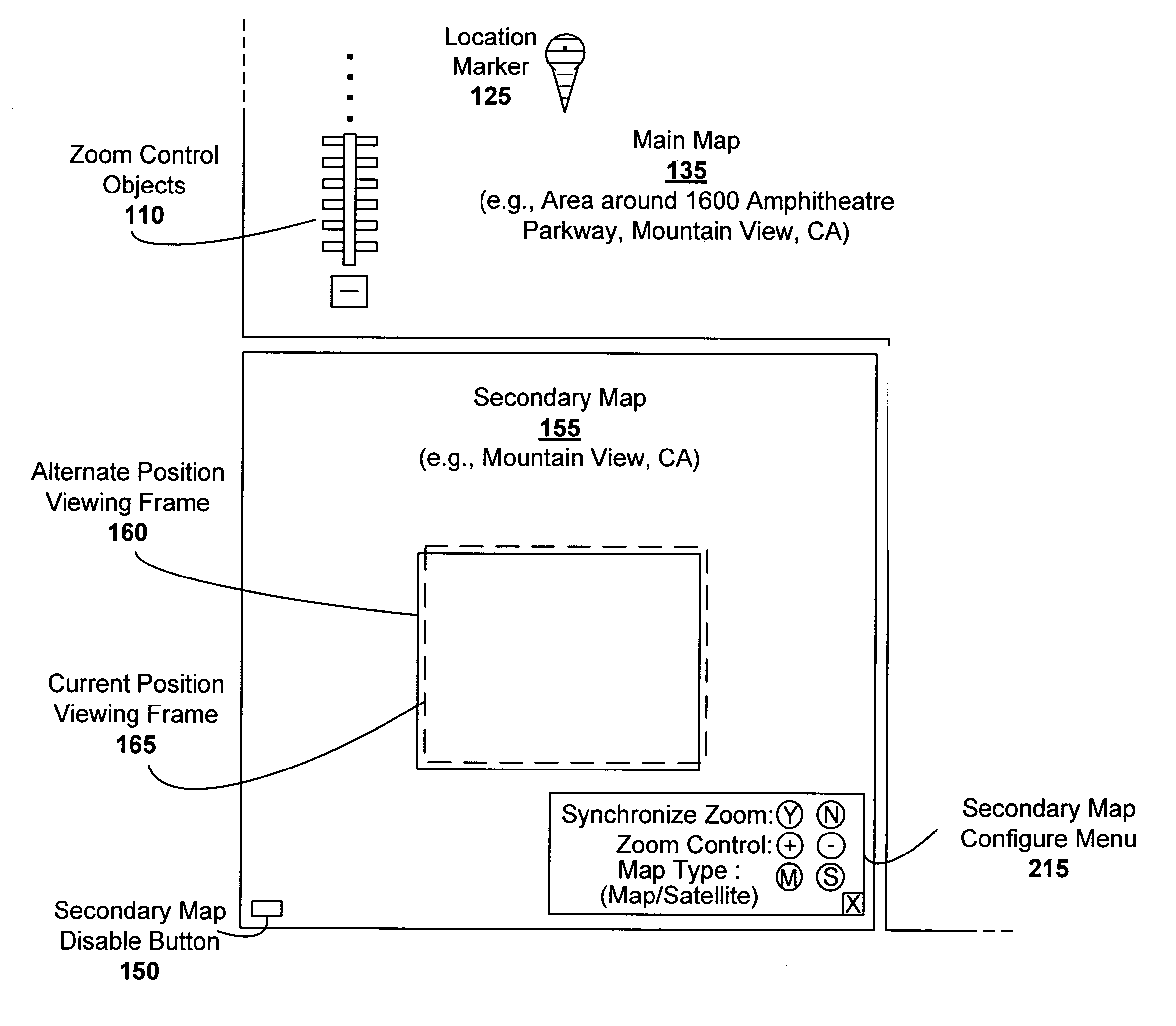
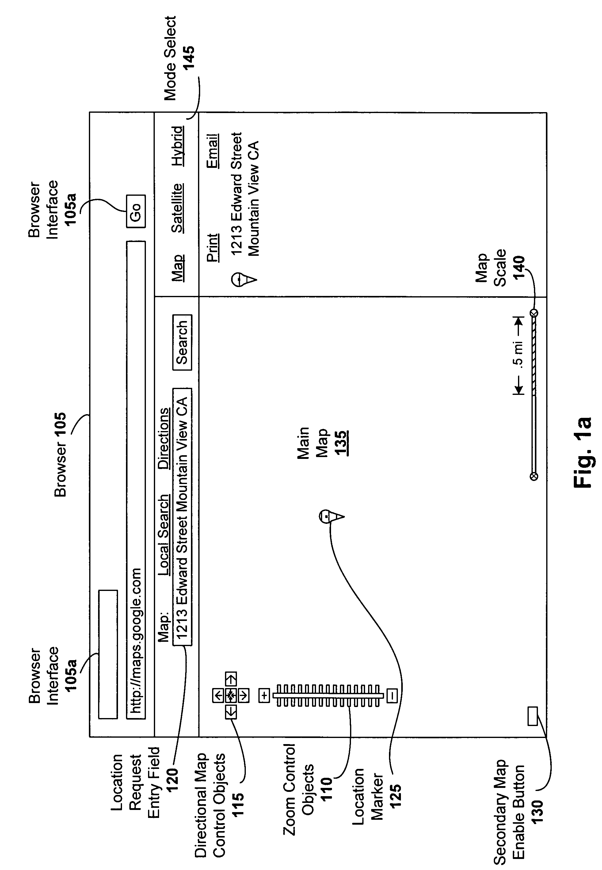
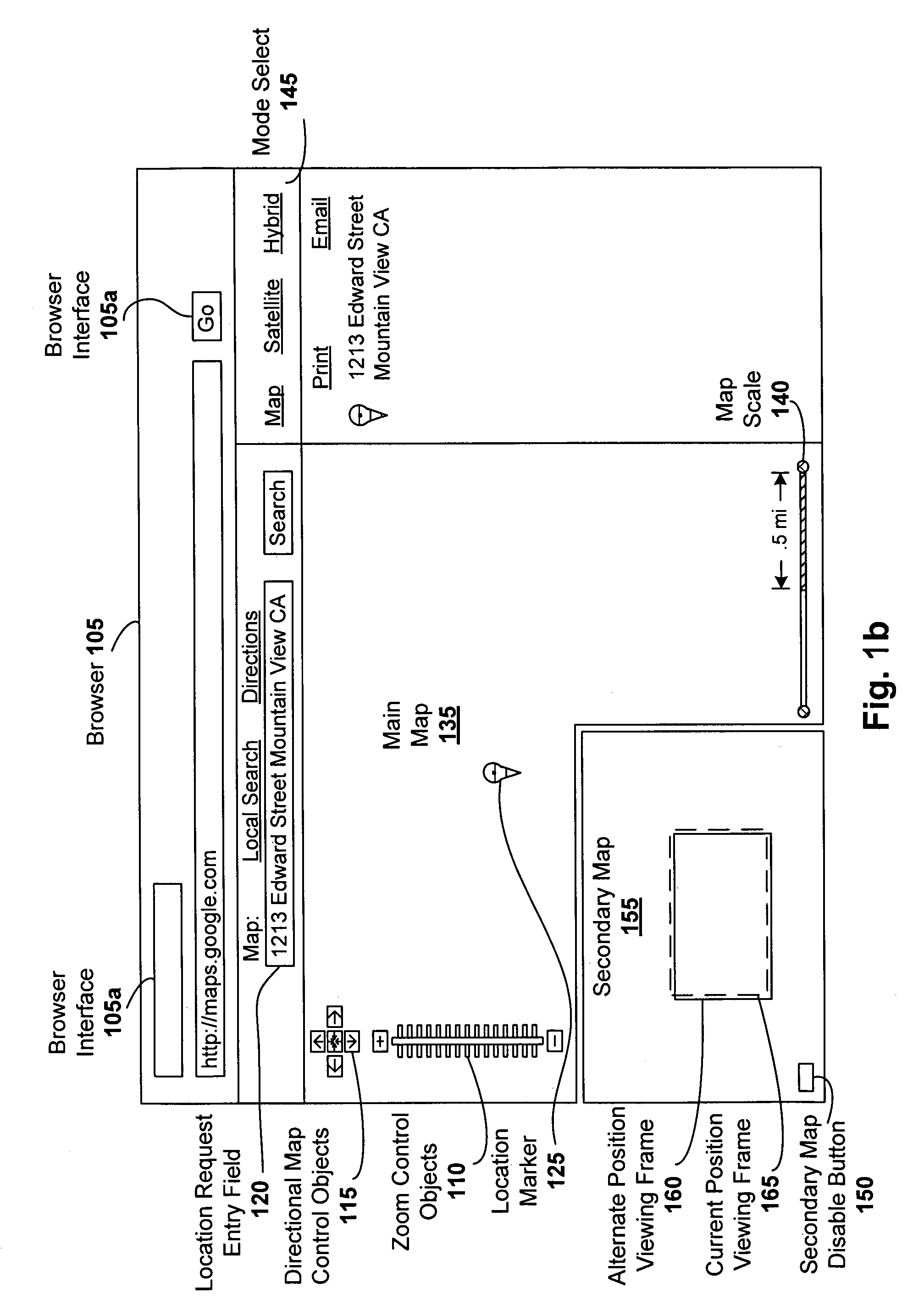
[0019]Digital mapping techniques are disclosed that provide more flexibility to the user through the use of multiple views of map information, including a main map and a secondary map, which can be located, for instance, in a corner of the main map.
[0020]The secondary map can provide the user with either a zoomed out map view (relative to the main map) for orientation (e.g., so as to enable informed panning), a zoomed in map view for specific area details, or a different type of map view relative to the main map view (e.g., main map can be a traditional drawn map and secondary map can be a satellite image or a hybrid of both traditional drawn map and satellite images). The secondary map can be turned on and off by the user. In cases where the secondary map shows a larger geographic area than the main map, the secondary map may include one or more viewing frames. For instance, one viewing frame may show the current position of the main map view, and another viewing frame can show the...
PUM
Abstract
Digital mapping techniques are disclosed that provide more flexibility to the user through the use of multiple views of map information, including a secondary map and a main map. The secondary map can provide the user with either a zoomed out or in relative to the main map, or a different type of map view (e.g., satellite images). The secondary map can be turned on and off by the user. The secondary map may include one or more viewing frames that indicate views (e.g., current and alternate views) of the main map. The user can move the main map, viewing frame, or secondary map to achieve desired map views. During such movement, the relationship between the main and secondary maps can be synchronous, partially synchronous, or serial.
Description
RELATED APPLICATIONS[0001]This application is a continuation-in-part of U.S. application Ser. No. 11 / 051,534, filed Feb. 5, 2005 now U.S. Pat. No. 7,158,878, titled “A Digital Mapping System”, which claims the benefit of U.S. Provisional Application Nos. 60 / 567,946, filed May 3, 2004, and 60 / 555,501, filed Mar. 23, 2004. In addition, this application is related to U.S. application Ser. No. 11 / 088,542, filed Mar. 23, 2005, titled “Generating and Serving Tiles in a Digital Mapping System”. Each of these applications is herein incorporated in its entirety by reference.FIELD OF THE INVENTION[0002]The invention relates to digital mapping systems, and more particularly, to an secondary map that can be synchronized with a main map to improve user experience.BACKGROUND OF THE INVENTION[0003]Computerized mapping systems have been developed to search for, identify, and discover information about geographic locations. One form of such computerized mapping systems includes travel-planning Inter...
Claims
Application Information
Patent Timeline
Application Date:The date an application was filed.
Publication Date:The date a patent or application was officially published.
First Publication Date:The earliest publication date of a patent with the same application number.
Issue Date:Publication date of the patent grant document.
PCT Entry Date:The Entry date of PCT National Phase.
Estimated Expiry Date:The statutory expiry date of a patent right according to the Patent Law, and it is the longest term of protection that the patent right can achieve without the termination of the patent right due to other reasons(Term extension factor has been taken into account ).
Invalid Date:Actual expiry date is based on effective date or publication date of legal transaction data of invalid patent.

