
High-precision monitoring method for cyanobacterial blooms in large shallow lake through MODIS (Moderate Resolution Imaging Spectroradiometer) and satellite

A cyanobacterial bloom, high-precision technology, applied in measurement devices, radio wave measurement systems, re-radiation of electromagnetic waves, etc., can solve problems such as difficulty in distinguishing

Active Publication Date: 2014-04-23
NANJING INST OF GEOGRAPHY & LIMNOLOGY
View PDF7 Cites 40 Cited by
  • Summary
  • Abstract
  • Description
  • Claims
  • Application Information

AI Technical Summary

Problems solved by technology

[0009] In addition, water blooms are similar to aquatic vegetation spectra, and it is difficult for all algorithms to achieve complete distinction and realize business operation

Method used


Image

  • High-precision monitoring method for cyanobacterial blooms in large shallow lake through MODIS (Moderate Resolution Imaging Spectroradiometer) and satellite
  • High-precision monitoring method for cyanobacterial blooms in large shallow lake through MODIS (Moderate Resolution Imaging Spectroradiometer) and satellite
  • High-precision monitoring method for cyanobacterial blooms in large shallow lake through MODIS (Moderate Resolution Imaging Spectroradiometer) and satellite

Examples


Embodiment Construction

[0071] The technical solution of the present invention is described in further detail below through specific examples, but it is necessary to point out that the following experiments are only used to describe the content of the invention, and do not constitute limitations to the protection scope of the present invention.

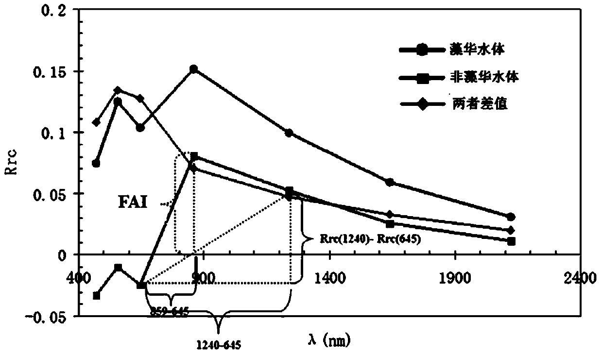
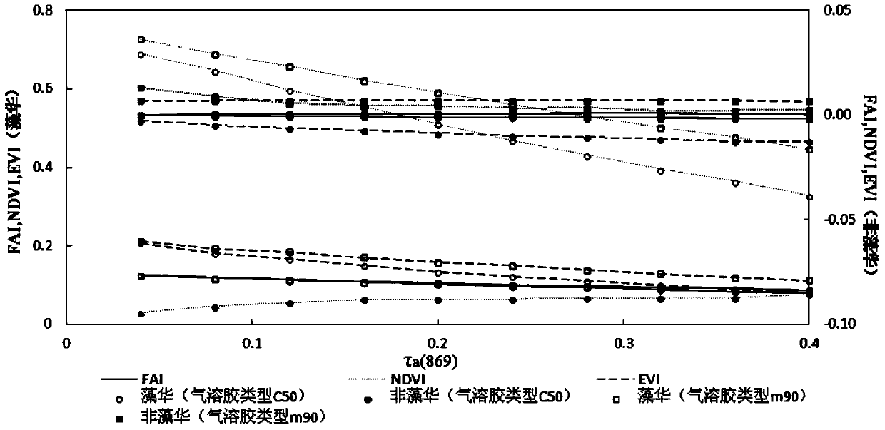
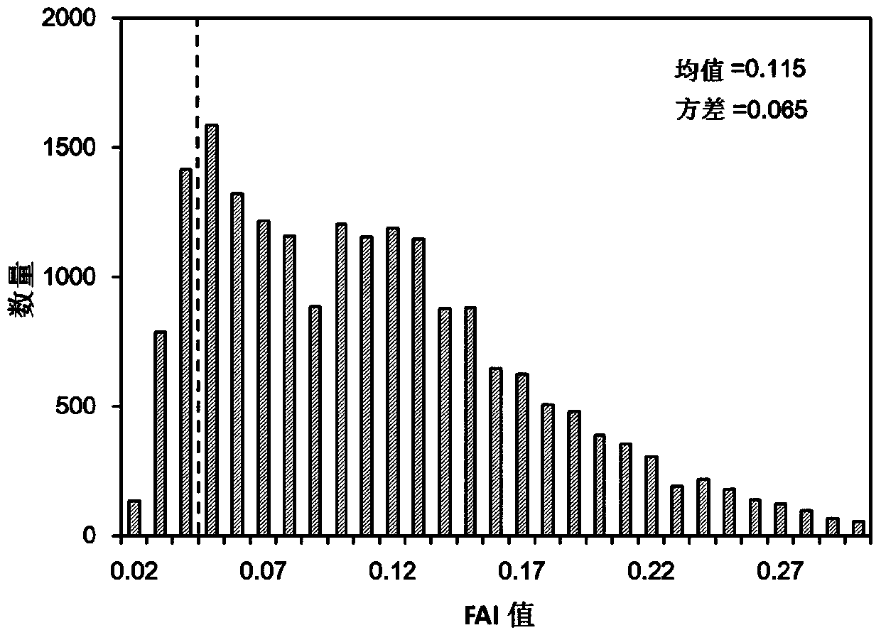
[0072] The present invention uses MODIS satellite data to carry out high-precision monitoring on the area of ​​algal blooms in large shallow lakes. The above-mentioned purpose is achieved in this way: screening the algal bloom identification index that is insensitive to the type and thickness of atmospheric aerosols; combining the synchronous MODIS and Landsat TM / ETM+ satellite imagery and gradient analysis results of water and land information to obtain the threshold value of pure pixel index of algal bloom; use the pixel growth algorithm (APA) to accurately calculate the algal bloom area in the mixed pixel of algal bloom; and then estimate the algal bloom in...


PUM


Abstract

The invention discloses a high-precision monitoring method for cyanobacterial blooms in a large shallow lake through an MODIS (Moderate Resolution Imaging Spectroradiometer) and a satellite. The high-precision monitoring method is characterized by comprising the following steps: screening recognition indexes of the cyanobacterial blooms (short for algal blooms) which are insensitive to the type and thickness of an atmospheric aerosol; combining the synchronous MODIS, LandsatTM / ETM and satellite image in 2000-2013 year and a gradient analysis result of land and water information to obtain a pure pixel index threshold value of the algal blooms; precisely calculating the area of the algal blooms in a mixed pixel (part of pixels covered by the algal blooms) of the algal blooms by using a pixel growth algorithm (APA); and furthermore, estimating the actual area of the algal blooms in the total water area of the lake and the areal distribution of the algal blooms. The high-precision monitoring method can be used for precisely obtaining the spatial and temporal distribution of the algal blooms in the shallow lake, accurately analyzing the generation and development condition and trend of the algal blooms, scientifically estimating the lake pollution control and ecological remediation effects and providing the scientific and technological support for making a scientific decision for water resource management and water environment protection of departments of water conservation, environment protection and the like.

Description

technical field [0001] The invention relates to a MODIS satellite high-precision monitoring method for cyanobacteria blooms in large shallow lakes. Background technique [0002] At present, satellite remote sensing technology has been widely used in the monitoring of cyanobacterial blooms, which provides the basis and basis for obtaining the temporal and spatial distribution of cyanobacterial blooms and the prediction and early warning of cyanobacterial blooms. However, in practice, it is found that even if the same remote sensing image is used, there are certain differences in the area of ​​algal blooms obtained by different departments and different personnel. The main reasons are the different algal bloom identification indexes and the sensitivity of algal bloom index to aerosol Different, ignoring algal bloom calculation of mixed pixels and misjudgment of aquatic vegetation. MODIS (MODerate-resolution Imaging spectroradiometer) data has high time resolution (0.5d) and s...

Claims


Application Information

Patent Timeline
IPC IPC(8): G01N21/3577G01S17/89
Inventor 张玉超马荣华段洪涛
Owner NANJING INST OF GEOGRAPHY & LIMNOLOGY
Learn More