Retrieval method for aerosol optical thickness based on high resolution satellite image data

A technology of optical thickness and high resolution, which is applied in the field of remote sensing to achieve the effect of improving inversion accuracy and increasing spatial resolution

Inactive Publication Date: 2017-02-15
INST OF REMOTE SENSING & DIGITAL EARTH CHINESE ACADEMY OF SCI
View PDF9 Cites 44 Cited by
  • Summary
  • Abstract
  • Description
  • Claims
  • Application Information

AI Technical Summary

Problems solved by technology

[0003] In view of the problem that the current high-resolution aerosol retrieval algorithm mainly focuses on dark targets and multi-satellite data collaborative retrieval, improve the application of high-resolution atmosph

Method used


Image

  • Retrieval method for aerosol optical thickness based on high resolution satellite image data
  • Retrieval method for aerosol optical thickness based on high resolution satellite image data
  • Retrieval method for aerosol optical thickness based on high resolution satellite image data

Examples


Embodiment Construction

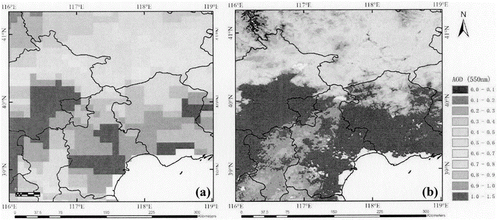
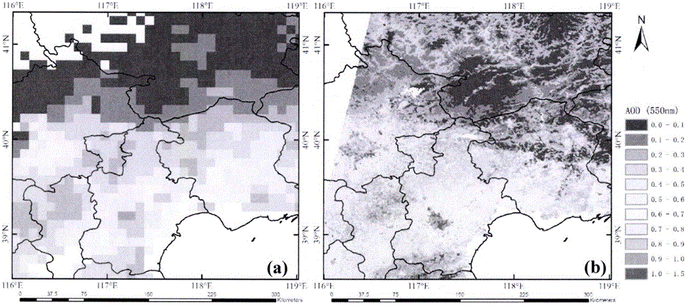
[0025] Compared with the existing aerosol retrieval sensors, high-resolution satellite sensors (such as the Gaofen-1 satellite) have extremely high spatial resolution, and the higher spatial resolution can reflect the regional and urban aerosol optical depth. The spatial distribution reflects the state of the urban atmospheric environment, and can identify pollution sources. Combined with other meteorological data, the pollution in a certain area can be comprehensively analyzed.

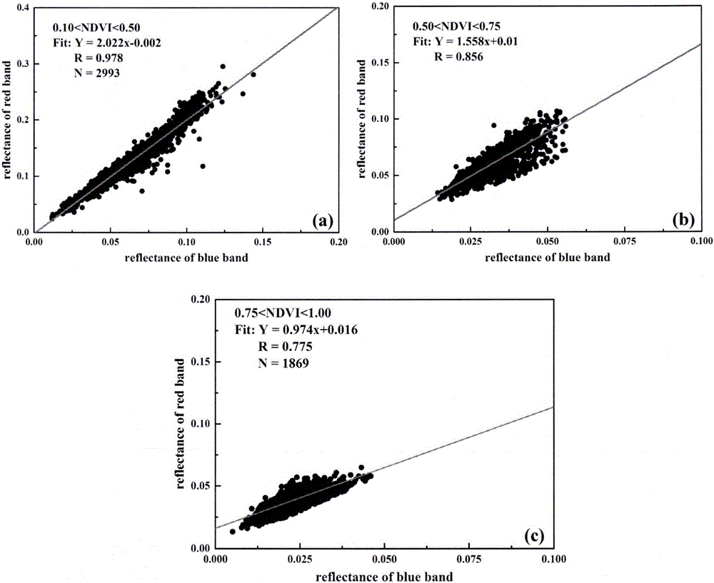
[0026] Therefore, this method takes full advantage of the high spatial resolution of high-resolution satellite camera data, uses the relationship between the pixel NDVI value and the red and blue band surface reflectance, separates the contribution of the surface from the observation signal, and obtains the aerosol optical depth.

[0027] For the surface of the Lambertian body under the parallel atmosphere, the upward reflectivity of the top layer of the atmosphere is produced by the interaction betwe...


PUM


Abstract

The invention discloses a retrieval method for an aerosol optical thickness based on high resolution satellite image data. The retrieval method specifically comprises the following steps: 1) establishing a lookup table according to a 6S radiation transfer model; 2) carrying out high resolution data preprocessing, comprising radiometric calibration, geometric correction and cloud detection, acquiring original apparent reflectance and observation angle information, and acquiring atmospheric parameters according to the observation angle information and the lookup table; 3) calculating the normalized differential vegetation index of each pixel, and determining a red-blue wave band relation corresponding to each pixel according to the vegetation index and priori knowledge provided by the invention; and 4) inverting the aerosol optical thickness according to the satellite observed apparent reflectance, the atmospheric parameters and the red-blue wave band relation. According to the remote sensing retrieval method for the aerosol optical thickness disclosed by the invention, aerosol monitoring can be carried out on high solution satellites effectively, and a data source can be provided for regional and urban atmospheric environment and pollution.

Description

technical field [0001] The invention relates to the field of remote sensing, in particular to an aerosol optical thickness inversion method based on high-resolution satellite image data. Background technique [0002] Atmospheric aerosol is one of the most important components of uncertainty in the atmosphere, which can be used to estimate the impact of aerosol on regional and global climate change. At present, various aerosol optical depth inversion methods (such as dark target algorithm and deep blue algorithm) are widely used in various satellite images. Monitoring of the optical properties of aerosols has also received increasing attention. A more refined aerosol distribution can be used to monitor the spatial distribution of aerosols in urban areas, and can effectively and quickly find pollution sources. Combined with other meteorological data, it can provide more accurate atmospheric environment monitoring and forecasting. At present, some researchers are working on t...

Claims


Application Information

Patent Timeline
IPC IPC(8): G06F19/00G01N15/06
CPCG01N15/06G16Z99/00
Inventor 顾行发包方闻程天海郭红王颖陈好师帅一徐斌仁
Owner INST OF REMOTE SENSING & DIGITAL EARTH CHINESE ACADEMY OF SCI
Why Eureka
Try Eureka