An aerosol remote sensing inversion method and system for lack of short-wave infrared data

A short-wave infrared and remote sensing inversion technology, used in instruments, mapping and navigation, measurement devices, etc., can solve the problems of large inversion errors of band correlation, lack of short-wave infrared bands, poor versatility, etc., to improve inversion accuracy, The effect of improving the universality and generality of the algorithm

Active Publication Date: 2021-05-07
NORTHEAST NORMAL UNIVERSITY
View PDF4 Cites 0 Cited by
  • Summary
  • Abstract
  • Description
  • Claims
  • Application Information

AI Technical Summary

Problems solved by technology

[0007] ① Lack of short-wave infrared band
[0010] ④ The above-mentioned dark target method and deep blue algorithm have poor versatility
[0011] ⑤ The inversion error of using band correlation relationship is relatively large

Method used


Image

  • An aerosol remote sensing inversion method and system for lack of short-wave infrared data
  • An aerosol remote sensing inversion method and system for lack of short-wave infrared data
  • An aerosol remote sensing inversion method and system for lack of short-wave infrared data

Examples


Embodiment

[0120] The present invention relates to an aerosol remote sensing inversion method and system for the lack of short-wave infrared data. The details involved in the technical solution of the present invention will be further described in detail below in conjunction with the accompanying drawings and embodiments; this embodiment uses a personal computer (PC) Simulation is carried out, and its software is based on 64-bit Windows 10 operating system and IDL secondary development platform.

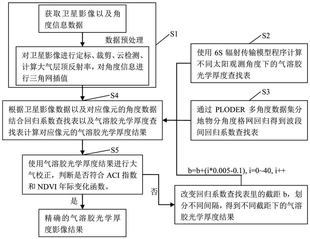
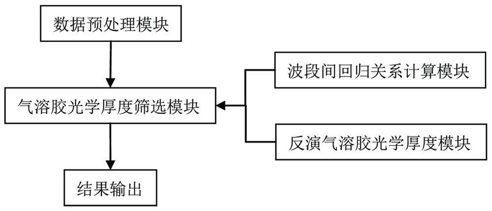
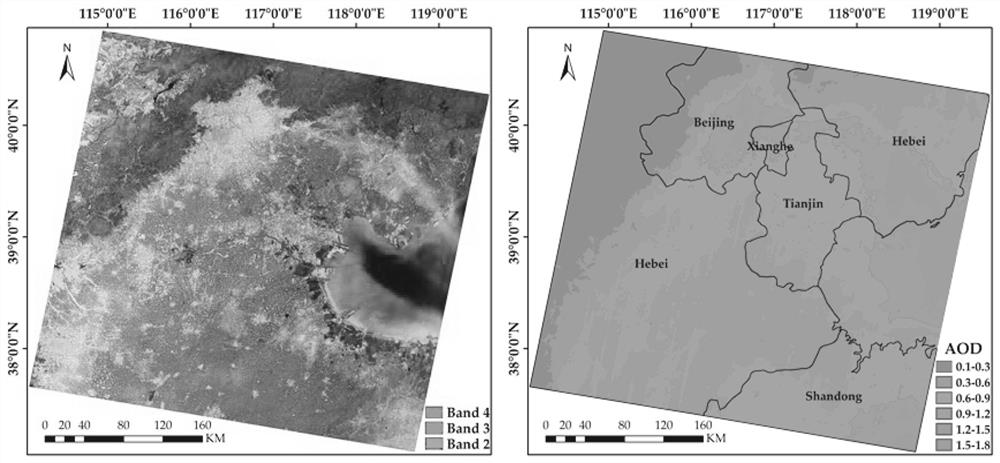
[0121] The embodiment adopted is the environmental satellite image downloaded in the China Resource Satellite Application Center, according to the technical scheme ( figure 1 ) to write the IDL processing system program, the system program structure is as follows figure 2 , debug and run the program to get the result of aerosol optical depth.

[0122] Write the inversion aerosol optical depth program: According to the technical plan ① satellite remote sensing image data preprocessing, includi...


PUM


Abstract

The invention discloses an aerosol remote sensing inversion method and system for lack of short-wave infrared data. In this method, considering the influence of angle and surface type on the band relationship, the multi-angle data set is used to construct the band regression coefficient lookup table for the sub-angle grid and sub-surface object type, and the aerosol optics of different surface object types are obtained by inversion. thickness. Aiming at the problem that the inversion results of aerosol optical depth have strong sensitivity to the relationship between bands, the aerosol correction index (ACI) and NDVI seasonal variation characteristics are introduced as constraints. The core technology of the present invention is based on the direct correlation relationship between the spectral bands of ground objects, combined with the influence of different solar observation angles on the band relationship, to establish an aerosol optical thickness lookup table and a band correlation lookup table, which can be quickly and accurately reflected by screening conditions. The inversion results of aerosol optical depth of different surface objects are obtained by deriving. Through the above technical means, the operating efficiency and inversion accuracy are improved.

Description

technical field [0001] The invention belongs to the technical field of remote sensing image processing, and in particular relates to an aerosol remote sensing inversion method and system for no short-wave infrared band data, and rapidly inverts to obtain high-resolution aerosol optical thickness products. Background technique [0002] Aerosol optical depth is an important geophysical parameter for the study of atmospheric pollution, aerosol radiation, atmospheric correction, etc. Satellite images can be used to monitor aerosol changes on a large scale and explain the impact of aerosols on the earth and the atmosphere on a spatial scale. Satellite remote sensing images contain information on the surface and the atmosphere, and the two interact with each other. The aerosols in the atmosphere lead to the loss of image details and large errors in the quantitative inversion of real information on the surface, also because of the influence of surface information. It also brings di...

Claims


Application Information

Patent Timeline
Patent Type & Authority Patents(China)
IPC IPC(8): G01C11/00
CPCG01C11/00
Inventor 樊宪磊瞿瑛白娥
Owner NORTHEAST NORMAL UNIVERSITY
Why Eureka
Try Eureka