Land surface soil moisture downscaling method based on multisource remote sensing satellite merged data

A technology for surface soil and soil moisture, applied in image data processing, structured data retrieval, electrical digital data processing, etc. The effect of improving model fitting accuracy, spatial coverage, and reliability

Inactive Publication Date: 2018-07-10
ZHEJIANG UNIV
View PDF4 Cites 41 Cited by
  • Summary
  • Abstract
  • Description
  • Claims
  • Application Information

AI Technical Summary

Problems solved by technology

However, there are at least two deficiencies in this process: (1) Optical data are easily affected by cloudy and rainy weather, and pixel loss is serious in cloudy and rainy areas. The characterization relationship between remote sensing data and surface soil moisture is not stable, and often changes with changes in geographical location, surface cover components, topographic factors, and other environmental factors. It is difficult to describe with a single mathematical model with strong universality (that is, using the same set of model coefficients)
This will reduce the correlation and robustness of the mathematical model of microwave soil moisture related to optical remote sensing parameters constructed in a large area, and ultimately affect the accuracy of high-resolution soil moisture data.

Method used


Image

  • Land surface soil moisture downscaling method based on multisource remote sensing satellite merged data
  • Land surface soil moisture downscaling method based on multisource remote sensing satellite merged data
  • Land surface soil moisture downscaling method based on multisource remote sensing satellite merged data

Examples


Embodiment Construction

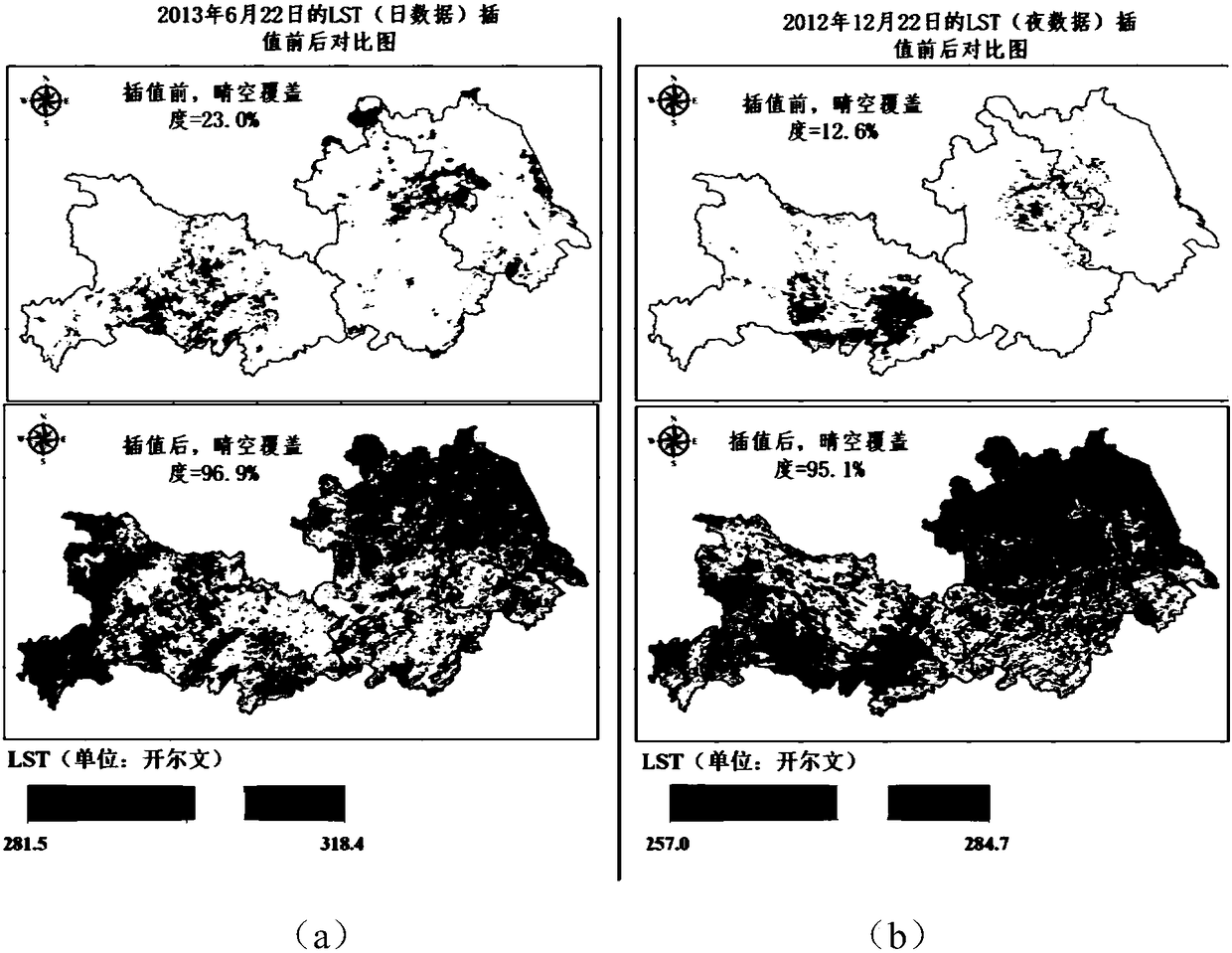
[0042]In the following, the three provinces of Jiangsu, Anhui and Hubei are taken as example research areas (cloudy and rainy weather), and the AMSR2 microwave soil moisture data set from September 1, 2012 to August 31, 2013 is used as the microwave soil moisture content to be downscaled Data, the present invention will be described in further detail in conjunction with specific accompanying drawings.

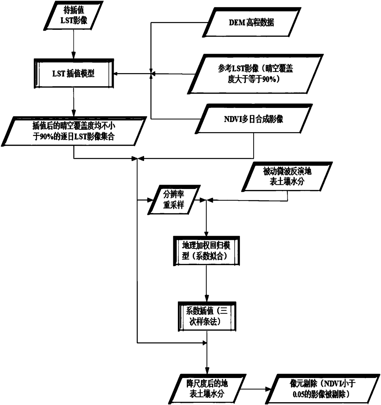
[0043] Such as figure 1 Shown is the flow chart of the present invention's method for downscaling surface soil moisture based on multi-source remote sensing satellite fusion data.

[0044] Step 1. Collect and organize passive microwave remote sensing soil moisture data sets and optical remote sensing data sets (LST and NDVI data sets) and other auxiliary data sets (DEM digital elevation model data);

[0045] The present invention has collected the AMSR2 microwave soil water content data (website: NASA's Earth Observing System Data and Information System) of 25km resolution on ...


PUM


Abstract

The invention discloses a land surface soil moisture downscaling method based on multisource remote sensing satellite merged data and is particularly applicable to cloudy and rainy areas. The method comprises the following steps: collecting and arranging a passive microwave soil moisture data set, an LST (land surface temperature) and NDVI (normalized difference vegetation index) data set and DEM(digital elevation model) data; performing spatial interpolation on LST images with serious pixel deletion affected by cloud and rain by adopting an NDVI and DEM data set as auxiliary data to obtain aday-by-day LST data set almost totally covering a research area; constructing a mathematic relation model for microwave soil moisture with optical remote sensing LST and NDVI by a geographical weighted regression model, and obtaining a land surface soil moisture data set with high spatial resolution with the mathematic relation model. Through the adoption of the method, reliability of a descalingresult and universality of descaling in the wide-range research area are improved effectively, and precision and efficiency of wide-range space mapping and monitoring for soil moisture content in thecloudy and rainy areas are improved.

Description

technical field [0001] The invention relates to the technical field of remote sensing surface soil moisture content inversion and downscaling, in particular to a method for downscaling surface soil moisture based on multi-source remote sensing satellite fusion data. Background technique [0002] Soil water is the unsaturated water body in the soil layer, which is widely distributed on the land surface. It is the link between surface water and groundwater, and is the necessary water source for plant growth. The amount of soil water resources plays a key role in the planting and growth of crops. my country is a country with extremely unbalanced distribution of soil and water resources. In the north of the Huaihe River and the vast central and western regions, there is less precipitation and water resources are poor. Soil and water resources have become one of the key factors restricting agricultural production; while water resources In the Jiangnan region, which is rich, especi...

Claims


Application Information

Patent Timeline
Patent Type & Authority Applications(China)
IPC IPC(8): G06F17/50G06F17/30G06T3/40
CPCG06F16/29G06F30/20G06F2111/10G06T3/4007G06T2207/10032Y02A90/10
Inventor 宋沛林黄敬峰
Owner ZHEJIANG UNIV
Why Eureka
Try Eureka