System and method for determining the location of a location tracking device

a technology of location tracking and location data, which is applied in the field of system and method of determining the location of a location tracking device, can solve the problems of affecting the accuracy of gps receivers, etc., and achieves the effect of currency and accuracy

Inactive Publication Date: 2012-02-21
WORLDSCOUT CORP
View PDF4 Cites 31 Cited by
  • Summary
  • Abstract
  • Description
  • Claims
  • Application Information

AI Technical Summary

Benefits of technology

[0021]The present invention does not require any special equipment to be installed at the base stations of the radio data communications network and is not limited to the use of base stations of any particular service provider and conventional roaming services can allow the present invention to be operated over large geographic areas including substantially global areas.

Problems solved by technology

While GPS and other satellite-based systems offer many advantages over RDF-based or other location technologies, they do suffer from disadvantages in that, due to the high radio frequencies and relatively low power levels at which the signals are transmitted, reception of signals from the satellites at a receiver is easily compromised by obstructions such as geographic features, buildings, trees, etc.
One of the disadvantages of the GPS system is that almanac data and ephemeris data is transmitted from the GPS satellites at a relatively low data rate and thus a GPS receiver needs to receive the GPS satellite signals, uninterrupted, for a relatively long time to obtain the required almanac data and ephemeris data.
A GPS receiver which experiences intermittent or poor reception of signals from one or more GPS satellites may not be able to obtain the required ephemeris data, even though the GPS receiver does have sufficient signal reception to receive the other GPS satellite data required for location determination purposes.
As location tracking devices are often operated in environments, such as cityscapes and urban areas, wherein GPS signal reception will be intermittent, this can result in poor performance of the location tracking system.
However, both GPS and AGPS-based location tracking devices still suffer from a problem in that, in addition to valid ephemeris and almanac data and reception of GPS satellite signals, a GPS receiver must also have an initial location position estimate to determine an actual location.
Conversely, an inaccurate initial location position estimate can significantly increase the time required to determine an actual location and, in cases wherein intermittent reception of the GPS satellite signals is experienced, may prevent a location determination from being achieved.
While GPS and AGPS receivers typically store their last determined location and employ that as the initial location position estimate, it is not uncommon that a receiver has been moved a significant distance since it last determined a location and thus this initial location position estimate can be a very poor one.

Method used


Image

  • System and method for determining the location of a location tracking device
  • System and method for determining the location of a location tracking device
  • System and method for determining the location of a location tracking device

Examples


Embodiment Construction

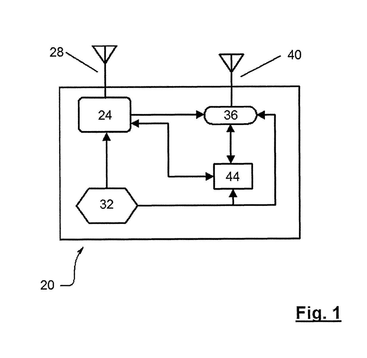
[0027]A location tracking device in accordance with the present invention is indicated generally at 20 in FIG. 1. Device 20 includes a GPS receiver 24 which is operable to receive and process signals from a satellite-based positioning system, such as the satellites of the GPS system to determine the location of device 20. GPS receiver 24 is connected to an antenna 28, which can be a microstrip or other antenna suitable for receiving GPS signals, and to a power supply 32, which can be a battery or other suitable power supply.

[0028]Device 20 further includes a data transceiver 36, such as a General Packet Radio Service (GPRS) transceiver which is connected to a suitable antenna 40. Antenna 40 can be part of antenna 28 or can be a separate antenna structure.

[0029]Transceiver 36 is operable to receive from a remote station data representing commands, etc. and to send data from device 20 to the remote station. The transmitted data can represent, without limitation, the location of device...


PUM


Abstract

A system and method for determining the location of a location tracking device employs a satellite based location determining infrastructure and a wireless data communications network. A location tracking device which cannot easily obtain valid ephemeris data from the satellite based location determining infrastructure requests the necessary data from a data set stored at a tracking device hub via the wireless communications network. The tracking device hub determines and transmits an estimated position of the location tracking device to the location tracking device, along with the appropriate required valid ephemeris data, to allow the location tracking device to determine its location. If the location tracking device is still unable to make a location determination from the satellite based location determining infrastructure, then the estimated location can be provided. The base station topography is self-determined by a process executing in the system and can include base stations from different networks.

Description

FIELD OF THE INVENTION[0001]The present invention relates to a system and method of determining the location of a location tracking device. More specifically, the present invention relates to a system and method for assisting a location tracking device, which primarily employs one location technology, such as the GPS system or the like, to determine its location in circumstances wherein the reception of signals from that location technology is impaired.BACKGROUND OF THE INVENTION[0002]Location tracking devices are well known and operate to provide a signal, indicating their present location, to a receiver at a remote location. Location tracking devices can be used, for example, to locate: vehicles, for fleet management, loss prevention, etc.; cargo, for logistics and loss prevention; people, for security and manpower management, etc.[0003]Location tracking devices typically comprise a small device which includes location determination circuitry and radio transceiver circuitry to rep...

Claims


Application Information

Patent Timeline
Patent Type & Authority Patents(United States)
IPC IPC(8): H04W24/00G01S19/06
CPCG01S19/06
Inventor BOSNJAKOVIC, MIROSLAVLAZOVIC, NENAD
Owner WORLDSCOUT CORP
Why Eureka
Try Eureka