Advanced cloud cover assessment

a cloud cover assessment and cloud cover technology, applied in image analysis, image enhancement, instruments, etc., can solve the problems of limited geographic referenced digital imagery, cloudy pixels are often viewed as defects, and the method of the '901 patent is not necessarily accurate over small bodies of water or land

Active Publication Date: 2013-11-26
MAXAR INTELLIGENCE INC
View PDF10 Cites 86 Cited by
  • Summary
  • Abstract
  • Description
  • Claims
  • Application Information

AI Technical Summary

Problems solved by technology

Thus, cloudy pixels are often viewed as a defect in the imagery.
In contrast, pixels obscured by clouds, or cloudy pixels, are of limited utility for geographically-referenced digital imagery.
In this situation, the remote sensing company spends considerable time and money either delineating the cloud locations in the imagery manually, investing in a system to detect clouds automatically in imagery, or performing a combination of both automated and manual processing.
Thus, the method of the '901 patent is not necessarily accurate over small bodies of water or land.
The '052 patent therefore suggests its method could not be successfully applied to high resolution imaging sensors, such as those used in modern high resolution imaging satellites.

Method used


Image

  • Advanced cloud cover assessment
  • Advanced cloud cover assessment
  • Advanced cloud cover assessment

Examples


Embodiment Construction

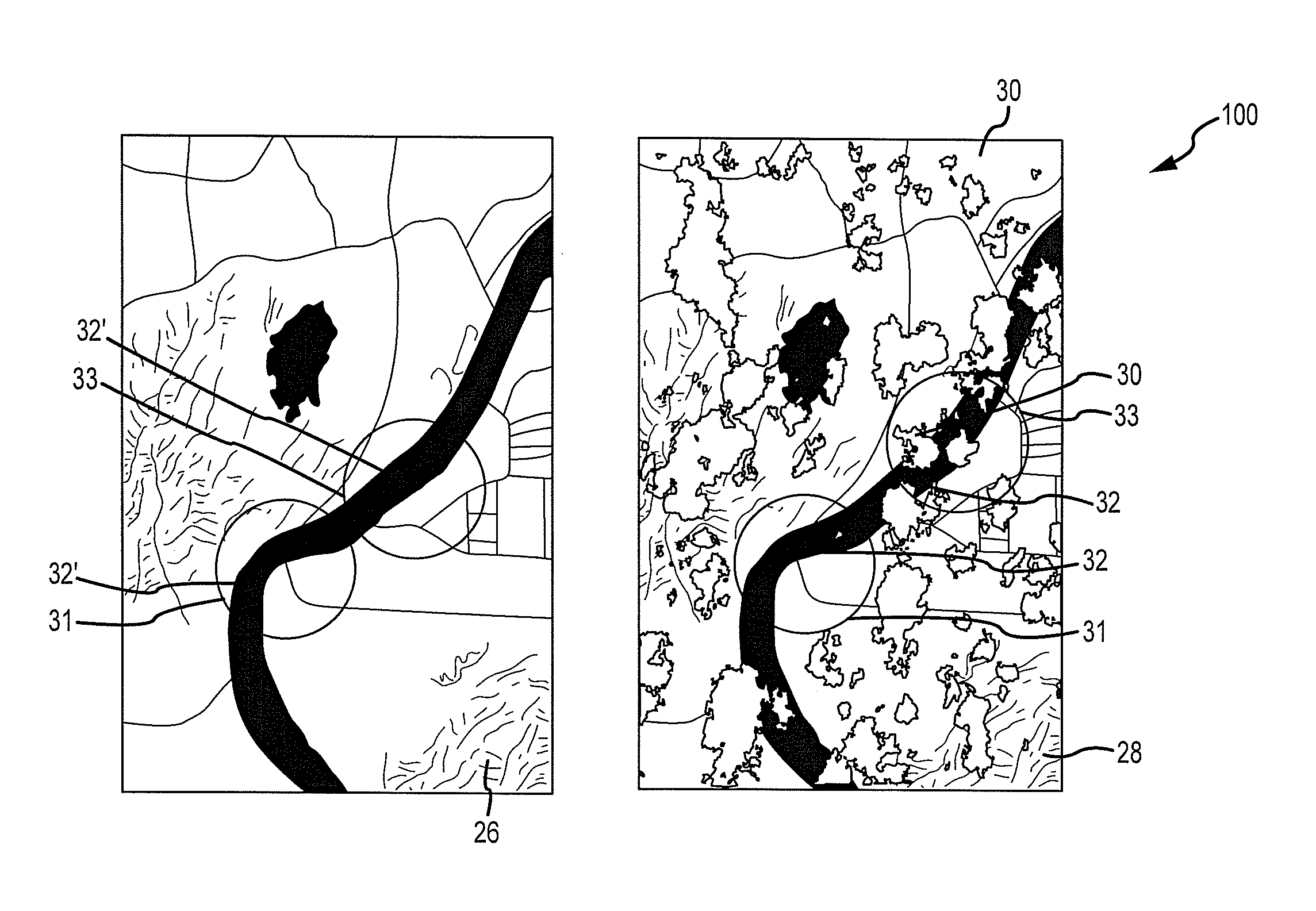
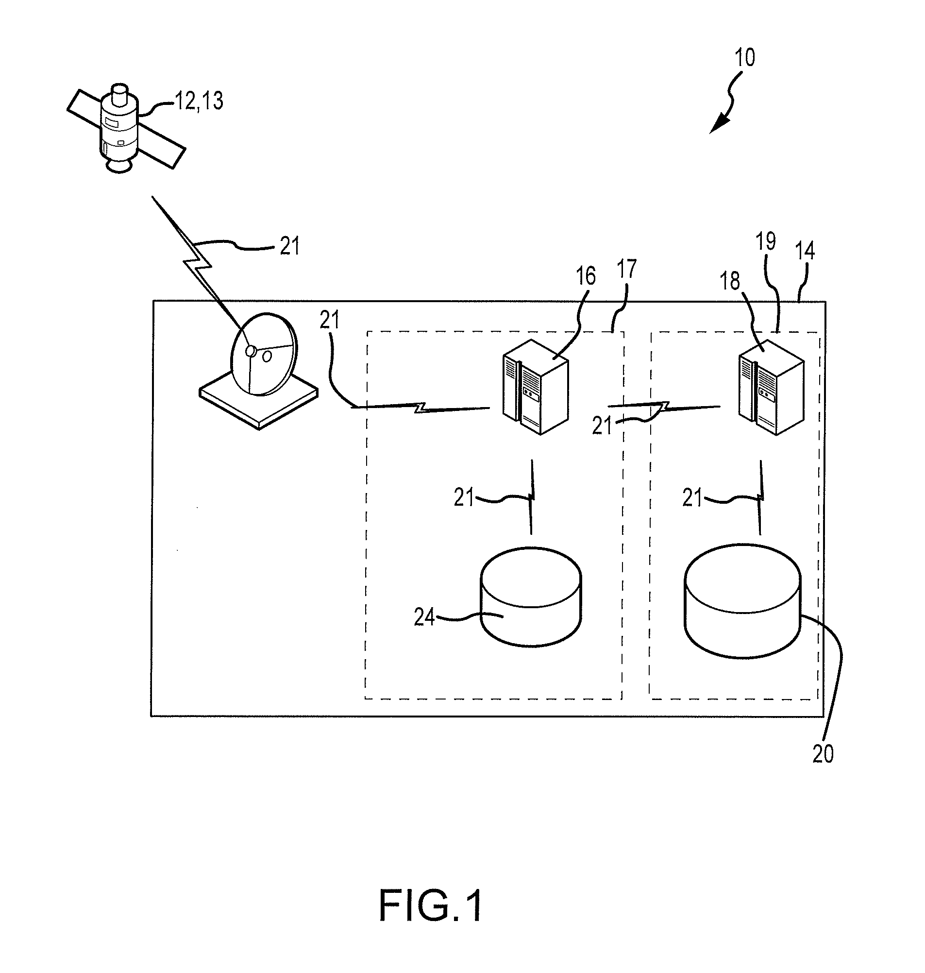
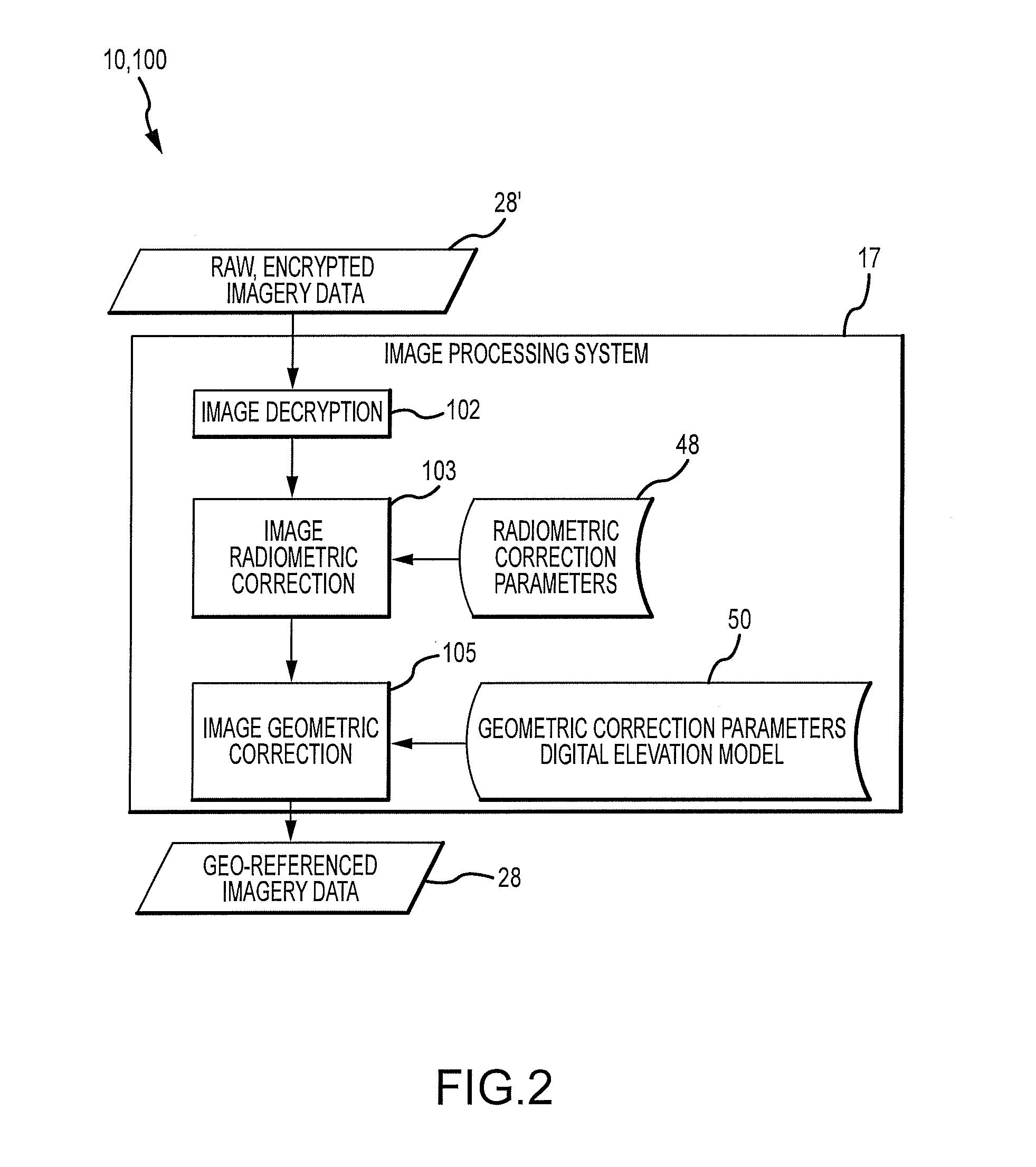
[0049]System 10 and method 100 of the present invention comprise or implement various processes for identifying cloudy pixels 30 in target image 28 by reference to cloud-free image 26 from cloud-free database 20. Embodiments of the present invention overcome prior art disadvantages (described below) in that they can be used with panchromatic imagery alone without the need to rely on additional information provided by digital images taken in other spectral bands.

[0050]Known functional techniques for cloud detection exploit multispectral imagery and make use of the spectral information collected by the sensor to distinguish cloudy pixels from non-cloudy pixels. However, these techniques are not designed to process panchromatic imagery.

[0051]While one technique called “thresholding” may be employed to create a cloud mask for panchromatic image data, it is not without its drawbacks. In practice, an input image is converted to top of atmosphere (TOA) reflectance (e.g., the ratio of the a...


PUM


Abstract

Cloud cover assessment system and method provides for automatically determining whether a target digital image acquired from remote sensing platforms is substantially cloud-free. The target image is acquired and compared to a corresponding known cloud-free image from a cloud-free database, using an optimized feature matching process. A feature matching statistic is computed between pixels in the target image and pixels in the cloud-free image and each value is converted to a feature matching probability. Features in the target image that match features in the cloud-free image exhibit a high value of feature matching probability, and are considered unlikely to be obscured by clouds, and may be designated for inclusion in the cloud-free database.

Description

CROSS-REFERENCE TO RELATED APPLICATION[0001]Applicant claims priority under 35 U.S.C. 119(e) to provisional patent application No. 61 / 346,567, which is incorporated herein by referenceFIELD OF THE INVENTION[0002]Embodiments generally relate to image processing, and more specifically to the automated detection and delineation of cloudy pixels in images of the Earth collected by high altitude or orbital overhead imaging sensors.BACKGROUND OF THE INVENTION[0003]Commercial remote sensing companies build and launch satellites that collect images of the Earth (sometimes referred to herein as “Earth Imaging” satellites). Often, a company will operate multiple satellites that collect digital images in a variety of spectral bands or channels. Sensors that collect radiation in a small, distinct number of separate spectral channels with narrow spectral band passes are called multispectral instruments. In layman's terms, such imagery is referred to as color imagery. Sensors that collect radiati...

Claims


Application Information

Patent Timeline
Patent Type & Authority Patents(United States)
IPC IPC(8): G06K9/00G06V20/13
CPCG06K9/4652G06K9/0063G06T7/001G06T2207/10041G06T2207/20076G06T2207/30181G06T2207/30232G06T7/0008G06V20/13
Inventor PADWICK, CHRIS
Owner MAXAR INTELLIGENCE INC
Why Eureka
Try Eureka