Method and device for displaying navigation circuit

A navigation route and display method technology, which is applied to road network navigators and other directions, can solve the problems of poor readability of navigation route maps, inability to clearly and completely display navigation routes, etc., and achieve the best readability, intuitive display, and clear display Effect

Active Publication Date: 2008-12-17
THE HONG KONG POLYTECHNIC UNIV
View PDF0 Cites 6 Cited by
  • Summary
  • Abstract
  • Description
  • Claims
  • Application Information

AI Technical Summary

Problems solved by technology

[0004] The purpose of the present invention is to provide a navigation route display method and a navigation route display device to overcome the poor readability of the navigation route map in the prior art and the inability to clearly and completely display the navigation route when the display screen size is limited Defects

Method used


Image

  • Method and device for displaying navigation circuit
  • Method and device for displaying navigation circuit
  • Method and device for displaying navigation circuit

Examples


Embodiment 1

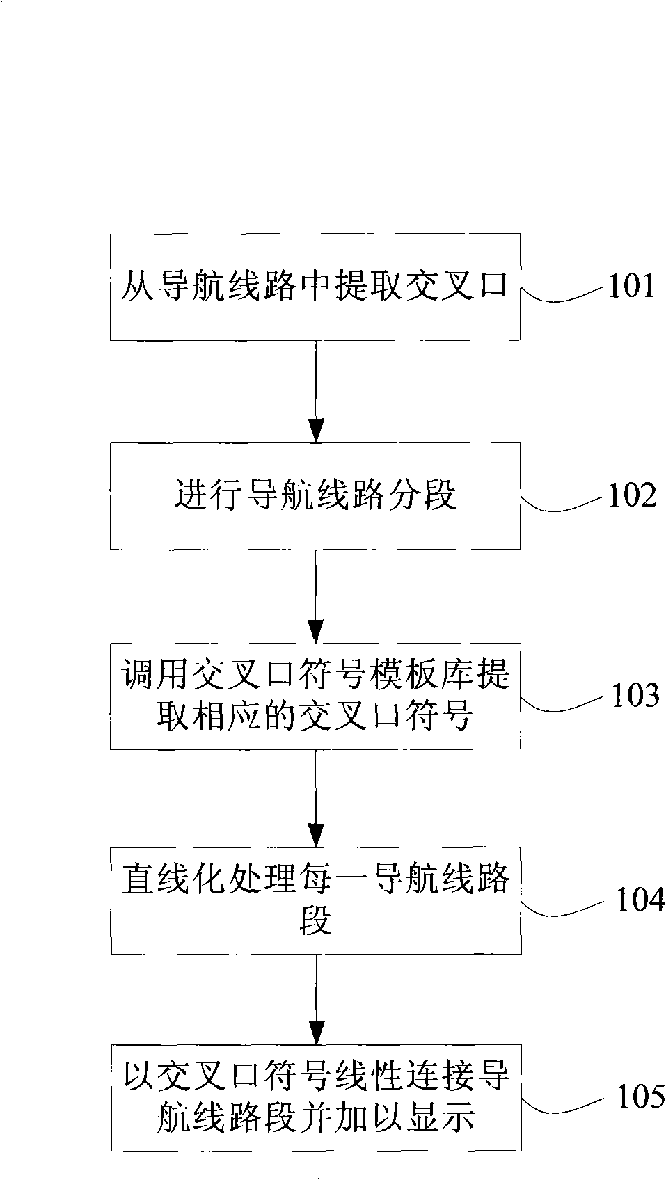
[0038] see figure 1 , is a flow chart of Embodiment 1 of the navigation route display method provided by the present invention, including the following steps:

[0039] 101. Extract the intersection from the acquired navigation route;

[0040] Since the present invention is an improvement on the display of the obtained navigation routes, and the actual acquisition process of the navigation routes can be carried out according to any method of obtaining the navigation routes in the prior art, such as manually typing in the names of the starting point and the end point, or selecting them through a touch screen. The starting point and end point, etc., and then obtain the navigation route by querying the traffic network database and choose one to output, so how to obtain the navigation route will not be repeated here. However, those skilled in the art can see that before this step 101, a step of obtaining the navigation route required for following should also be included. Typica...

Embodiment 2

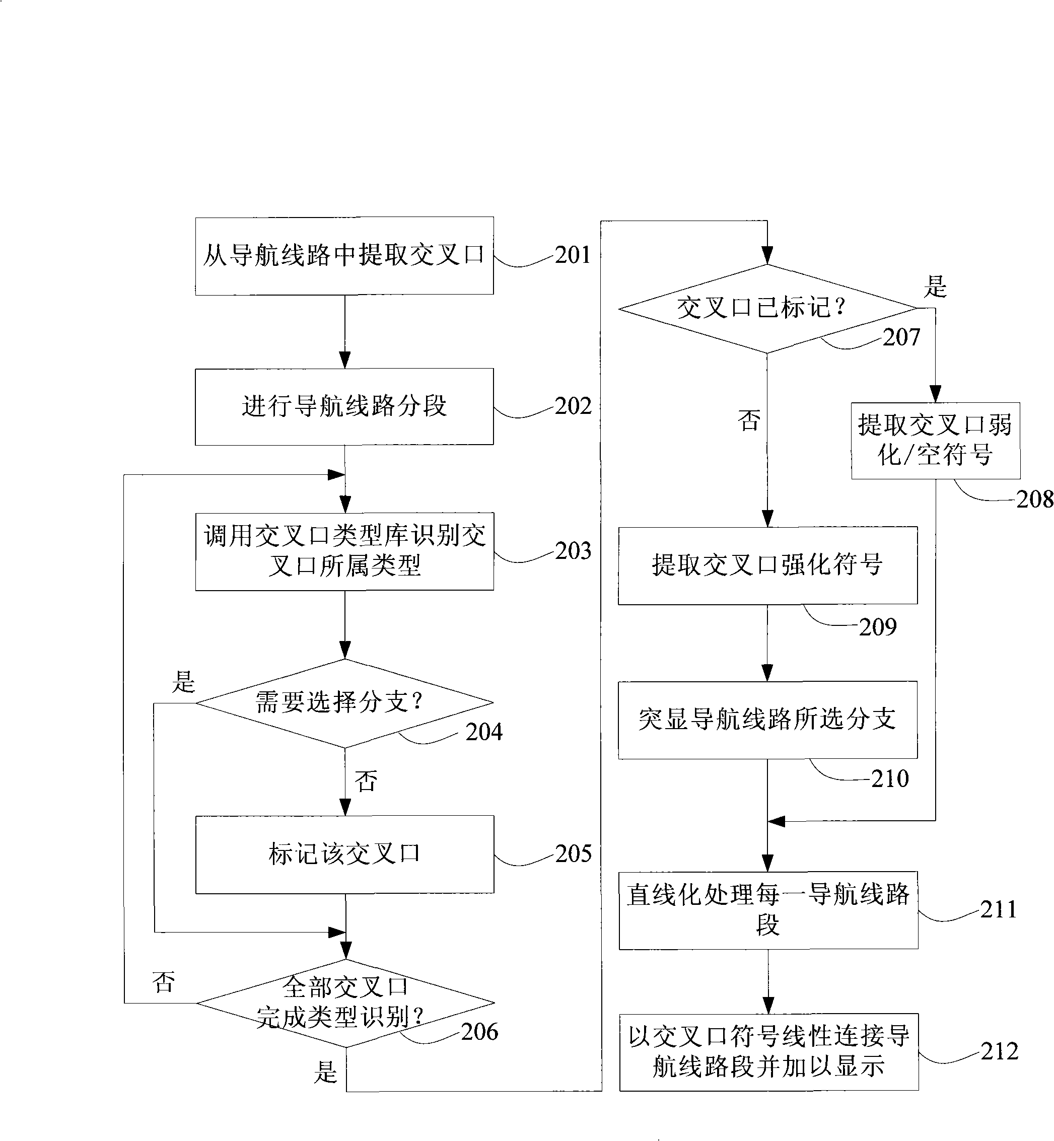
[0061] Based on the content described in Embodiment 1, different types of intersections can be distinguished according to whether the intersection is marked or not in the process of intersection symbolization, and different intersection symbols can be selected for display, for example, no need to select a branch intersection (such as Figure 6 Middle intersection C), intersection without turning (such as Figure 6 Intermediate intersections A) and / or other intersections that need to be weakened / ignored are displayed with intersection weakened symbols or intersection empty symbols, while intersections with turns and need to select branches are displayed with intersection strengthening symbols.

[0062] For the convenience of explanation, the display level is introduced here, such as:

[0063] When the current display level is the first level, the intersections that do not need to select branches will be displayed with intersection weakened symbols or intersection empty symbols...

Embodiment 3

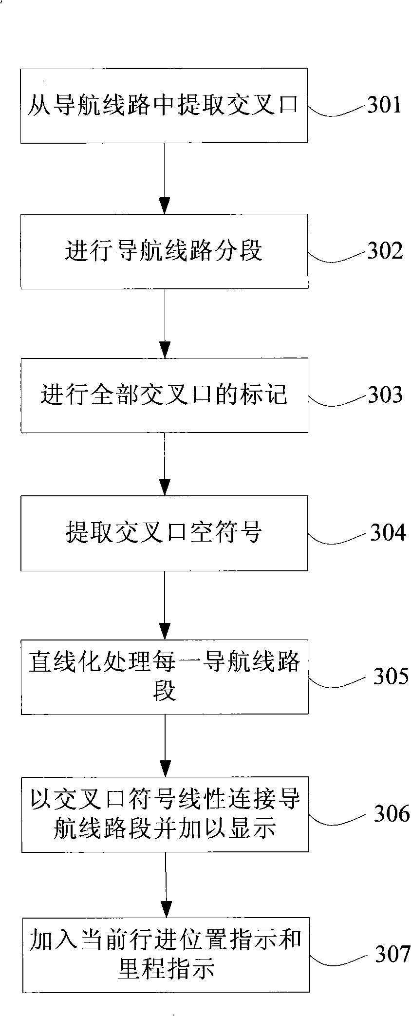
[0098] In the simplest case, all intersections can be marked, and the marked intersections can be marked with weakened intersection symbols or empty intersection symbols to achieve the effect of simplifying the entire line, which is especially suitable for the dynamic display of mileage . Because the traveling subject often wants to know the mileage when traveling, that is, how far has been traveled, how far is left, etc., the mileage indicator map is used to understand the mileage at a glance, including the starting point, the end point, the line segment of the overall route and the current position indication. Embodiment 3 of the navigation route display method provided by the present invention provides such a technical solution, such as image 3 shown, including the following steps:

[0099] 301. Extract the intersection from the acquired navigation route;

[0100] 302. Segment the navigation route according to the extracted intersection;

[0101] 303. Mark all intersect...


PUM


Abstract

The invention discloses a navigation route display method, which comprises the following steps: extracting crossings from acquired navigation routes; segmenting the navigation route according to the extracted crossings; calling a crossing symbol template base for anyone of the extracted crossings and extracting corresponding crossing symbol; linearizing each segment of the navigation route; and linearly connecting the linearized segments of the navigation route by the extracted crossing symbols, and displaying. The invention also discloses a navigation route display device. The method and the device disclosed by the invention can clearly, concisely and intuitively display the navigation route information and have good readability. Particularly, the device can completely and clearly display the navigation route on a smaller screen.

Description

technical field [0001] The invention relates to a navigation route display technology, in particular to a navigation route display method and a navigation route display device for linearly and symbolically displaying a navigation route. Background technique [0002] The navigation route map is used to present the planned route to the user in graphical form, so as to realize the navigation function for vehicles and pedestrians. [0003] Currently, the navigation route Figure 1 Generally, the display method of highlighting the actual track of the line on the background map is adopted. This kind of navigation route map has more redundant information besides the information required for following the navigation route (such as the situation at the turn, the name of the road entering / traveling and exiting / exiting the road, etc.), which interferes with the follow-up navigation. Clear presentation of the information required for the route, thus affecting the readability of the nav...

Claims


Application Information

Patent Timeline
IPC IPC(8): G01C21/26G01C21/30
Inventor 李志林陈武徐柱陈永奇张奕港
Owner THE HONG KONG POLYTECHNIC UNIV
Why Eureka
Try Eureka