Combined locator

A locator and position information technology, applied in the field of navigation, can solve the problems of increasing positioning and navigation errors, accumulation of errors, inability to accurately locate and navigate, and achieve the effect of accurate positioning information and good compatibility.

Active Publication Date: 2011-06-22
BEIJING BDSTAR NAVIGATION CO LTD
View PDF0 Cites 0 Cited by
  • Summary
  • Abstract
  • Description
  • Claims
  • Application Information

AI Technical Summary

Problems solved by technology

[0004] At present, a common practice is to apply the inertial navigation system to GNSS. When the GNSS positioning and navigation are affected, the positioning and navigation is carried out through the inertial navigation system; however, the positioning and navigation error of the inertial navigation system will continue to increase with time. Large, resulting in the accumulation of errors, resulting in the problem of inability to accurately locate and navigate

Method used


Image

  • Combined locator
  • Combined locator
  • Combined locator

Examples


Embodiment 1

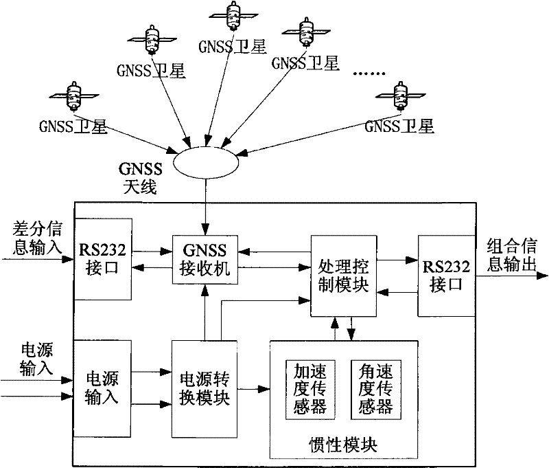
[0035] Embodiment 1, a combined locator, including an inertial module and a processing control module. The system below refers to the combination locator or the vehicle, device or equipment carrying the combination locator; because the movement of the combination locator is attached to the vehicle, device or equipment carrying the combination locator, so this article The so-called "system static" is equivalent to the static of the combined locator, and also corresponds to the static of the vehicle, device or equipment carrying the combined locator. The "system position", "system speed" and "system speed" mentioned in this article The same goes for "moving distance".

[0036] The inertial module is used to provide information for position reckoning.

[0037] In this embodiment, the position estimation information includes acceleration and angular velocity; the inertial module includes an acceleration sensor and an angular velocity sensor; other devices for measuring velocity / a...


PUM


Abstract

The invention discloses a combination locator comprising an inertial module used for providing position estimation information, and a processing control module used for receiving GNSS information and the position estimation information output by the inertial module. When the GNSS information is usable, the locator directly outputs the GNSS information which includes position information, speed information and course information; when the GNSS information is absent or useless, the locator estimates according to the position estimation information and outputs results which include position information, speed information and course information; and when in a static state, the locator makes no summation in terms of position, speed and course information which is output before the static state. When the invention is used for navigation positioning, the error accompanying the static state is not magnified by the accumulation of time.

Description

technical field [0001] The invention relates to the field of navigation, in particular to a combined locator. Background technique [0002] At present, the commonly used technology for navigation and positioning is to use GNSS (Global Navigation Satellite System, Global Navigation Satellite System); GNSS system calculates positioning information by receiving wireless signals sent by GNSS satellites, and can perform high-precision positioning in real time; however, wireless signals have a linear propagation Characteristics, its dynamic performance and anti-interference performance are poor, when the GNSS receiving module is in a place where satellite signals will be blocked or interfered, it will not be able to locate accurately or even fail to locate. [0003] Inertial positioning and navigation system, referred to as inertial navigation system, has independent navigation capability, can provide positioning and navigation information such as carrier attitude, speed and posit...

Claims


Application Information

Patent Timeline
Patent Type & Authority Patents(China)
IPC IPC(8): G01C21/26G01S5/02
Inventor 申红军胡丽丽高永
Owner BEIJING BDSTAR NAVIGATION CO LTD
Why Eureka
Try Eureka