Method for capturing C/A code signal of GPS

A C/A code and signal technology, applied in the field of GPS communication, can solve the problem that the GPS signal acquisition method cannot be fast and accurate, and achieve the effect of improving the acquisition performance and achieving high precision

Inactive Publication Date: 2009-06-24
许军
View PDF0 Cites 21 Cited by
  • Summary
  • Abstract
  • Description
  • Claims
  • Application Information

AI Technical Summary

Problems solved by technology

[0032] The purpose of the present invention is to provide a method for capturing the C / A code signal of GPS to solve the problem that the currently used GPS signal capturing method cannot be both fast and accurate

Method used


Image

  • Method for capturing C/A code signal of GPS
  • Method for capturing C/A code signal of GPS
  • Method for capturing C/A code signal of GPS

Examples


Embodiment Construction

[0060] The preferred embodiments will be described in detail below in conjunction with the accompanying drawings. It should be emphasized that the following description is only exemplary and not intended to limit the scope of the invention and its application.

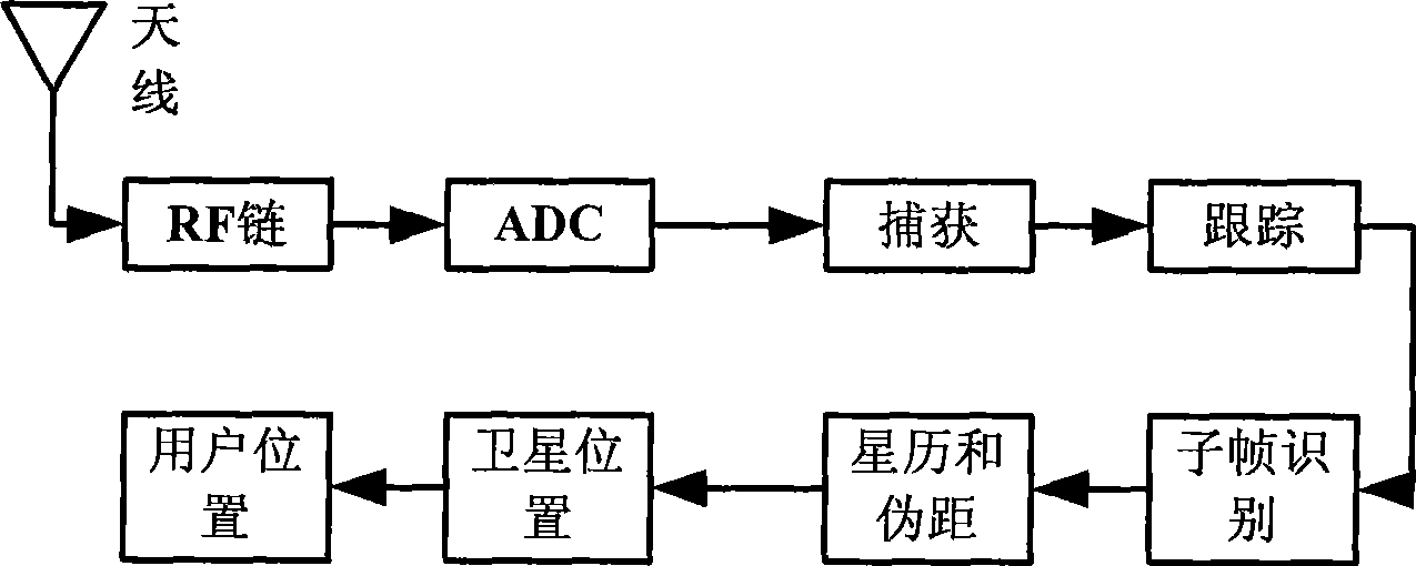
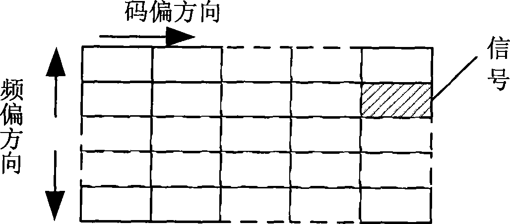
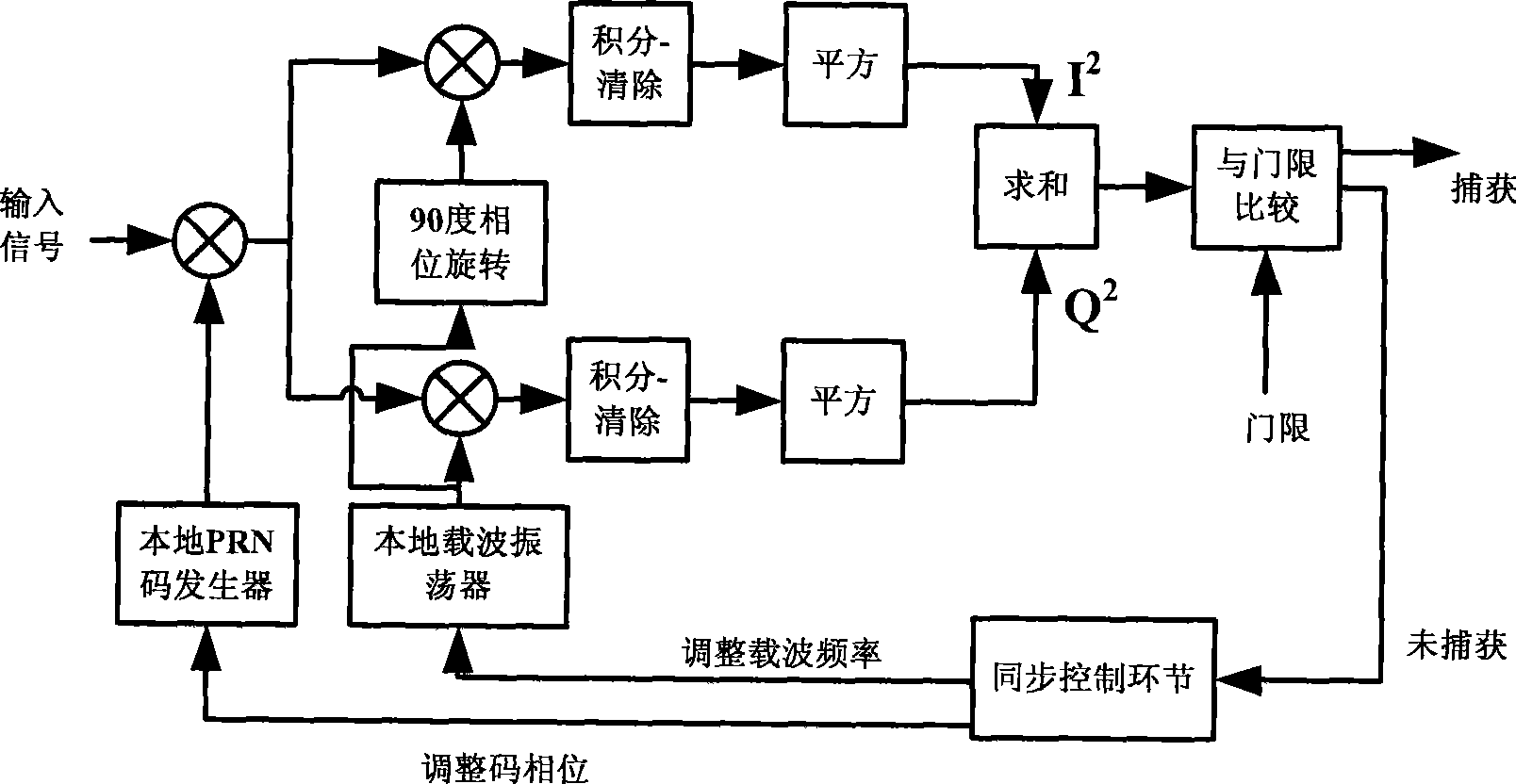
[0061] The invention provides a GPS C / A code signal acquisition method, which includes a rough acquisition process and a fine acquisition process. The idea of ​​the present invention is: firstly, search L satellites in parallel, and L is set by the system; use FFT-based code phase search to obtain rough code phase and carrier frequency; judge whether the preset threshold used for successful capture The value is set to a fixed empirical value, or a value set according to the noise size; if the correlation value of the FFT-based code phase search output is greater than the preset threshold value, it is necessary to correspond to each correlation value greater than the preset threshold value Code phase and carrier freque...


PUM


Abstract

The invention discloses a method for acquiring the C / A code signals of a GPS in the GPS communication technical field. The method comprises a rough acquisition process and a precise acquisition process. The rough acquisition process comprises the following steps: searching a plurality of parallel satellites set by a system and obtaining a rough code phase and carrier frequency by using code phase search based on FFT; and the precise acquisition process comprises the following steps: setting a precise acquisition carrier frequency step according to the code phase and the carrier frequency obtained from rough acquisition and determining the search scope of precise acquisition; and removing the correlation between input signals and local carrier signals influenced by the code phase and comparing a correlation value and a resetting threshold value to determine whether satellite signals can be really acquired. Compared with the prior GPS acquiring method, the invention improves the acquisition performance of GPS signals, ensures the GPS fast acquisition, and simultaneously achieves the high-accuracy requirements of the GPS acquisition.

Description

technical field [0001] The invention belongs to the technical field of GPS communication, in particular to a method for capturing C / A code signals of GPS. Background technique [0002] GPS (Global Positioning System), as a new generation of satellite navigation and positioning system, was originally developed by the US military and used by the armed forces. After years of development, the current GPS system has become a widely used military-civilian dual-use system. Its application fields and application prospects far exceed the original imagination of the system designer. In almost all fields such as resource exploration, communication, and meteorology, it is used as a very important technical means and method for navigation, timing, positioning, measurement of geophysical parameters, and measurement of atmospheric physical parameters. [0003] The GPS global positioning system is a radio space positioning system, which uses navigation satellites and ground stations to pro...

Claims


Application Information

Patent Timeline
IPC IPC(8): G01S5/02G01S5/14G01S19/24
Inventor 赖建文
Owner 许军
Why Eureka
Try Eureka