Subway train running monitoring system based on a vector electronic map

An electronic map and monitoring system technology, applied in the fields of automatic system, railway signal and safety, etc., can solve the problems that cannot reflect the concept of urban rail transit network

Active Publication Date: 2009-08-26
CASCO SIGNAL
View PDF0 Cites 12 Cited by
  • Summary
  • Abstract
  • Description
  • Claims
  • Application Information

AI Technical Summary

Problems solved by technology

[0002] The traditional GIS system can only display the static lines of the static rail transit, and the traditional ATS system can only display the abstract signal equipment status and train position with the horizontally connected lines, which cannot reflect the road network concept of urban rail transit

Method used


Image

  • Subway train running monitoring system based on a vector electronic map

Examples


Embodiment Construction

[0008] The present invention will be further described below in conjunction with specific examples.

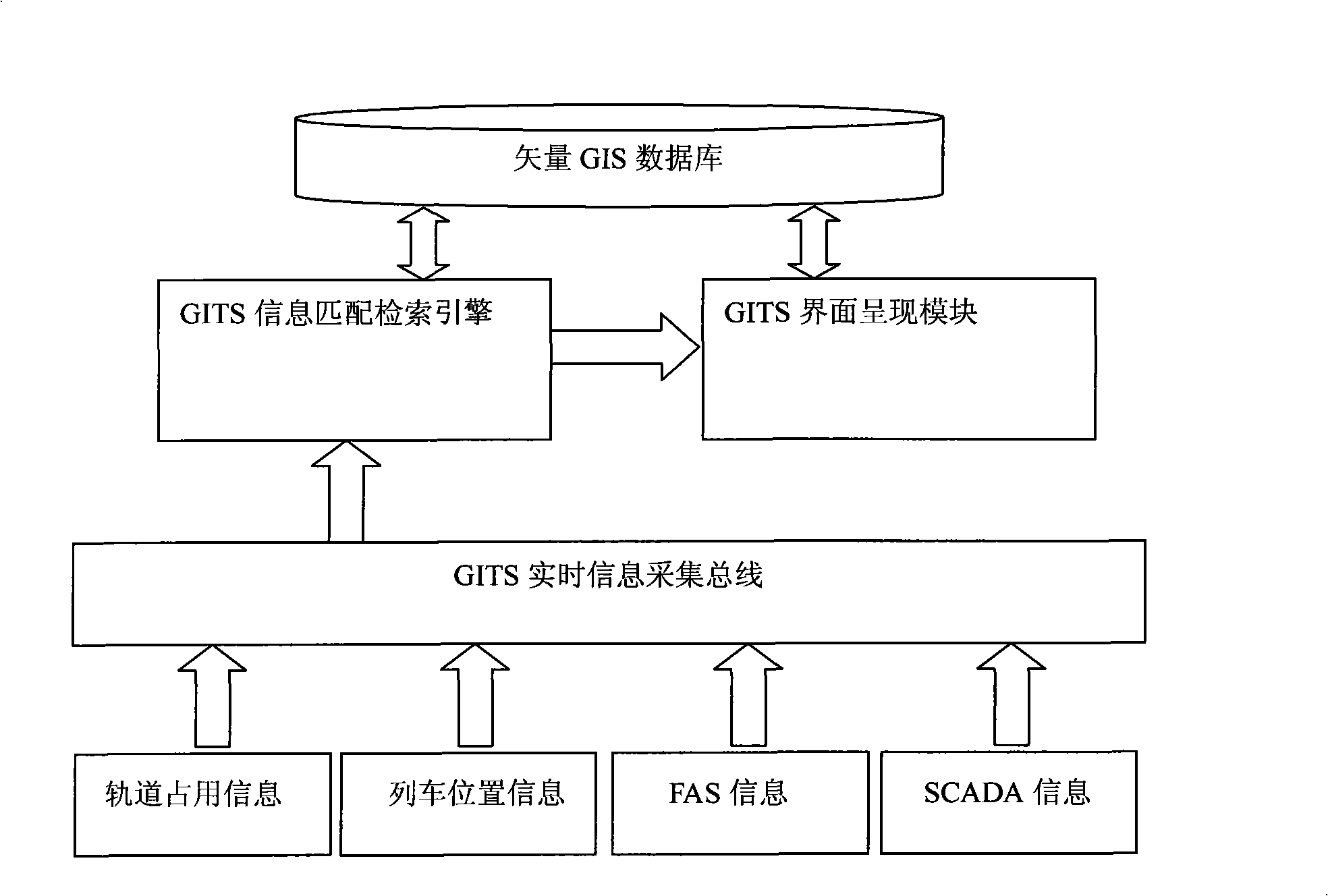
[0009] Such as figure 1 As shown, in GITS, the GITS real-time information collection bus interfaces with the iTS system to obtain train track occupancy information, train running position information, interfaces with the FAS system to obtain the status information of the fire alarm system, and interfaces with the SCADA system to obtain the line power supply arm power status information. And send the information to the GITS information matching search engine for processing.

[0010] The GITS information matching retrieval engine performs retrieval and matching of geographic information on real-time information in the vector GIS database, and converts the relative information of the train running position into urban geographic coordinates.

[0011] The GITS interface presentation module loads the city vectorized electronic map from the GIS database, and obtains the dynamic geo...


PUM


Abstract

The invention relates to a subway train running monitoring system based on a vector electronic map. The system comprises a vector GIS database, a GITS message matching and searching engine, a GITS interface presenting module and a GITS real-time message acquiring bus, wherein the vector GIS database is respectively connected with the GITS message matching and searching engine and the GITS interface presenting module; the GITS message matching and searching engine is connected with the GITS interface presenting module; and the GITS message matching and searching engine is connected with the GITS real-time message acquiring bus. Compared with the prior art, the method combines a geography message system and a subway train automatic monitoring system, takes a municipal electronic geography map as a presenting interface and realizes the static display of the whole municipal railway traffic network map and the dynamic display of train running. The method is particularly suitable for municipal railway traffic emergency direction centers and municipal traffic bureau direction centers to monitor the macroscopy of the whole railway traffic network.

Description

technical field [0001] The invention relates to a geographic information system (GIS) and a subway train automatic monitoring system (ATS), in particular to a subway train operation monitoring system (GITS) based on a vector electronic map. Background technique [0002] The traditional GIS system can only display the static lines of the static rail transit, and the traditional ATS system can only display the abstract signal equipment status and train position with horizontally connected lines, which cannot reflect the road network concept of urban rail transit. The GITS architecture solves these problems better. On the basis of this architecture, it can also realize the automatic dispatching, adjustment and management of trains, thereby reducing the workload of dispatchers and watchmen and optimizing the efficiency of line operation. Contents of the invention [0003] The purpose of the present invention is to overcome the above-mentioned defects in the prior art, and prov...

Claims


Application Information

Patent Timeline
Patent Type & Authority Applications(China)
IPC IPC(8): B61L23/00B61L27/04
Inventor 孙军峰陈今缨王曙光
Owner CASCO SIGNAL
Why Eureka
Try Eureka