High-resolution remote sensing image search method fused with spatial relation semantics

A technology of remote sensing image and spatial relationship, applied in special data processing applications, instruments, electrical digital data processing, etc.

Inactive Publication Date: 2011-08-17
NANJING NORMAL UNIVERSITY
View PDF0 Cites 0 Cited by
  • Summary
  • Abstract
  • Description
  • Claims
  • Application Information

AI Technical Summary

Problems solved by technology

This kind of method mainly has the following problems: 1) the workload of manual annotation is too large; 2) manual annotation is subjectivity and uncertainty
This method of expressing the spatial relationship of objects can achieve good retrieval results for conventional images (common multimedia, medical images, etc.) with a single background and a small number of objects, but it is not suitable for remote sensing images.
This is because remote sensing images, compared with ordinary multimedia and medical images, have various types of ground features, very complex distributions, and very complex combinations of spatial relationships between them, which are difficult to describe clearly with the above quadruple method

Method used


Image

  • High-resolution remote sensing image search method fused with spatial relation semantics
  • High-resolution remote sensing image search method fused with spatial relation semantics
  • High-resolution remote sensing image search method fused with spatial relation semantics

Examples


Embodiment Construction

[0113] The present invention will be further described in detail below in conjunction with the drawings and embodiments.

[0114] Data preparation: The experimental data are 50 SPOT-5 images with a size of 1024×1024 and a resolution of 10 meters. The remote sensing image is a multispectral image with 4 bands.

[0115] Offline processing part of remote sensing image:

[0116] (1) Principal component transformation

[0117] Perform PCA transformation on all images to obtain corresponding PCA images.

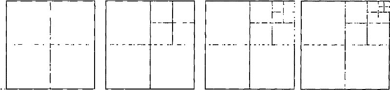
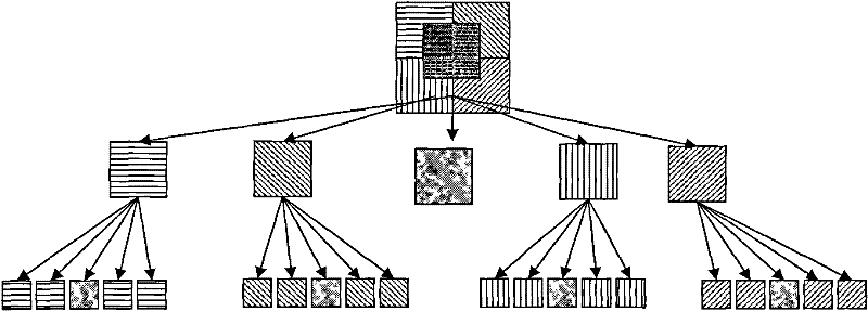
[0118] (2) Image decomposition and visual feature extraction based on pentatree

[0119] The PCA image is decomposed into a five-point tree, and the image is divided into a series of sub-images. Image segmentation has two main purposes. One is to obtain remote sensing images of different sizes and a certain degree of image overlap. These are the basis for the image database to be retrieved. The second is to be able to divide the image into leaf node images for feature extraction, and each...


PUM


Abstract

The invention discloses a high-resolution remote sensing image search method fused with spatial relation semantics and the method comprises two parts, namely the off-line treatment of remote sensing image and the on-line search of the remote sensing image. In the off-line treatment part, the visual features of the remote sensing image is firstly extracted and the visual feature, spatial object semantic and spatial relation semantic features are stored in relational database. In the on-line search part, the searching is performed according to the object semantic feature of the image to obtain a rough search result; then a template image is selected from the rough search result, further searching is performed to the rough search result according to the visual feature of the template image and the spatial relation semantic feature to return to the visual feature and the spatial semantic feature and assemble with the similar images of the selected template image, and the searching processis completed. As the method comprehensively uses the visual feature of image and the spatial object semantic and spatial relation semantic features, higher search precision can be obtained.

Description

Technical field [0001] The invention relates to a method for querying and retrieving high spatial resolution remote sensing images (hereinafter referred to as high resolution remote sensing images), in particular to a high resolution remote sensing image retrieval method fusing spatial relationship semantics and image visual features, belonging to Remote sensing image processing and information extraction field. technical background [0002] Remote sensing image retrieval (or called remote sensing image query) is the process of finding images or image sequences that users are interested in from a remote sensing image database. With the rapid increase in the amount of remote sensing image data, how to effectively manage the huge image database and quickly and accurately query and retrieve image information has become an urgent problem to be solved. Summarizing the current research progress, there are three main methods for remote sensing image retrieval: [0003] (1) Text-Based Im...

Claims


Application Information

Patent Timeline
Patent Type & Authority Patents(China)
IPC IPC(8): G06F17/30
Inventor 汪闽万其明
Owner NANJING NORMAL UNIVERSITY
Why Eureka
Try Eureka