Vanishing point based method for automatically extracting and classifying ground movement measurement image line segments

A technology of mobile measurement and classification methods, applied in the direction of photo interpretation, etc., can solve the problems of less misclassification and low level of automatic processing, and achieve the effect of reducing the number, improving the processing capacity of the office, and theoretically rigorous

Inactive Publication Date: 2010-12-15
TONGJI UNIV
View PDF4 Cites 17 Cited by
  • Summary
  • Abstract
  • Description
  • Claims
  • Application Information

AI Technical Summary

Problems solved by technology

[0004] The purpose of the present invention is to solve the problem that the automatic processing level of the current mobile measurement technology is not high in engineering surveying and mapping, GIS data update and three-dimensional reconstruction of ground objects, etc., and proposes a method for automatically extracting and classifying ground mobile measurement image line segments based on vanishing points. Based on the vanishing point theory in photogrammetry, it establishes a mathematical model corresponding to the image line segment and the feature line segment of space features, which is theoretically rigorous and reliable, and can accurately extract all the line segments that should belong to the vanishing point class (that is, "not good results with very few misclassifications

Method used


Image

  • Vanishing point based method for automatically extracting and classifying ground movement measurement image line segments
  • Vanishing point based method for automatically extracting and classifying ground movement measurement image line segments
  • Vanishing point based method for automatically extracting and classifying ground movement measurement image line segments

Examples


Embodiment Construction

[0017] The present invention will be further described below in conjunction with the embodiments shown in the accompanying drawings.

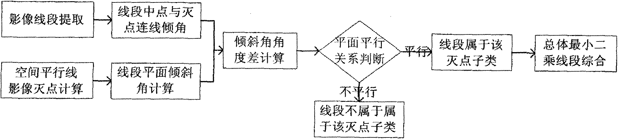
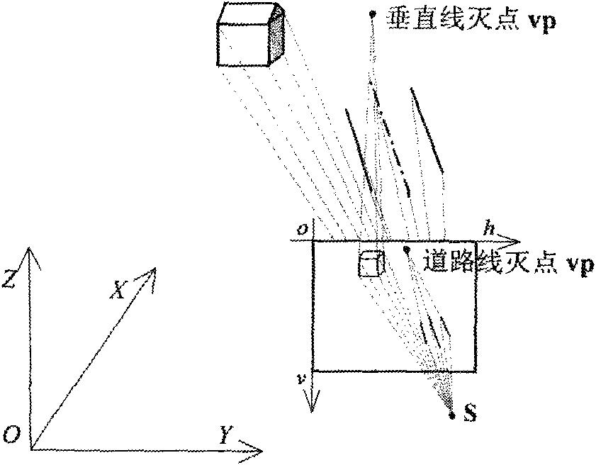
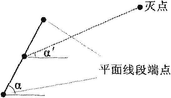
[0018] The content of the present invention generally includes: line segment extraction based on image edge features, space parallel line vanishing point calculation and image plane line segment classification based on vanishing point, line segment adjacency and overlap judgment grouping centered on vanishing point after classification, and overall minimum The square line segment integrates three aspects, and has two outstanding features: First, the core mathematical model is based on the known vector of the spatial parallel line (the vector can be provided by the attributes of the ground object, the motion characteristics of the mobile measurement work, etc.) and the known internal and external orientation elements. Image acquisition, the model is rigorous and reliable in theory for the classification of image line segments, and can significant...


PUM


Abstract

The invention relates to a vanishing point based method for automatically extracting and classifying ground movement measurement image line segments. The method comprises the following steps of: firstly, analyzing the attribute of ground object space parallel characteristic lines of a target and calculating vanishing points of an image of the target on the basis of image sequences acquired by ground movement measurement; secondly, extracting characteristic line segments based on an image edge according to the Hough transform of a polar coordinate parameter area extremum and the continuous change of image greyscale; and then, classifying the extracted plane line segments by using vanishing points; and finally integrating the classified line segments according to a total least square method and conditions of the plane adjacency and overlapping degree of the line segments so as to extract image characteristic line segments which correspond to multiple ground object space parallel lines. The invention can improve the indoor processing capability of a movement measurement system and promote the research on automatic recognition, mapping, three-dimensional reconstruction and the like of multiple ground objects (such as buildings, roads and the like).

Description

technical field [0001] The invention relates to the application requirements of mobile measurement for spatial information update, automatic surveying and mapping of ground objects and three-dimensional reconstruction, as well as the scope of disciplines such as digital photogrammetry and digital image processing, and specifically relates to a ground mobile measurement image line segment based on a vanishing point Automatic extraction of classification methods. Background technique [0002] Mobile surveying is one of the representatives of modern surveying and mapping high-tech integrated with spatial information 3S technology (GPS, RS and GIS). It has the characteristics of rich information records, fast acquisition speed, high degree of automation, and low operating cost. Opened up a fast and efficient new way. The ground mobile measurement system provides a powerful production capacity for measuring close-range real-scene images from the ground perspective. Automatic rec...

Claims


Application Information

Patent Timeline
Patent Type & Authority Applications(China)
IPC IPC(8): G01C11/04
Inventor 欧建良王卫安鲍峰李荣兴乔刚杜泽明
Owner TONGJI UNIV
Why Eureka
Try Eureka