Method for precisely correcting satellite-borne optical linear array image based on linear characteristic
A technology of straight line features and processing methods, applied in the interpretation of photos, etc., can solve problems such as different imaging parameters, inability to correctly calculate model parameters, and inability to select control points
- Summary
- Abstract
- Description
- Claims
- Application Information
AI Technical Summary
Problems solved by technology
Method used
Image


Examples
Embodiment
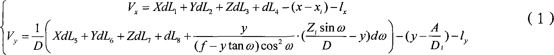
[0058] A precise rectification and processing method for spaceborne optical linear array images based on straight line features, without using control points, and directly using the straight line features of remote sensing images and the ground to accurately correct spaceborne optical linear array images, the specific steps are as follows:
[0059] 1) Build a model;
[0060] 2) Calculate the initial parameters of the model;
[0061] 3) Calculate the precise parameters of the model;
[0062] 4) Correction of spaceborne optical remote sensing images.
[0063] The specific implementation method is described below with an implementation example, that is, to implement geometric correction based on line features for a high-resolution spaceborne optical remote sensing image (SPOT5 image), according to the used remote sensing data SPOT5 image, through the line feature-based The geometric correction, its accuracy can meet the requirements of 1:50,000 topographic maps.
[0064] The i...
PUM
 Abstract
Description
Claims
Application Information