Method for rapidly locating current region of vehicle

A region and vehicle technology, applied in traffic control systems, instruments, and calculations of road vehicles, can solve problems that affect retrieval efficiency, slow reading and retrieval processes, and data efficiency issues, and achieve fast retrieval and convenience Reading and editing, efficient effects

Inactive Publication Date: 2011-08-10
XIAMEN YAXON NETWORKS CO LTD
View PDF6 Cites 14 Cited by
  • Summary
  • Abstract
  • Description
  • Claims
  • Application Information

AI Technical Summary

Problems solved by technology

The realization of GPS vehicle-mounted terminal area monitoring needs to judge the area surrounded by the connection lines of multiple GPS points. In this way, it is necessary to read and operate the information of multiple GPS points every time an area is judged. If the terminal actively judges the entry and exit of the area, it is necessary to save a large amount of area location information in the vehicle-mounted terminal, which will inevitably bring about efficiency problems in the management and retrieval of its data, and if the reading and retrieval process is too slow, it will affect the terminal. Real-time performance of regional monitoring
[0003] Usually, when locating the area to which the vehicle belongs, the area data is directly stored in the vehicle-mounted terminal in the order of increase without planning. When judging whether the vehicle is located in a certain area at the moment, the polling method without purpose is adopted. This kind of processing without any management will inevitably bring many meaningless operations, which will affect the efficiency of retrieval

Method used


Image

  • Method for rapidly locating current region of vehicle
  • Method for rapidly locating current region of vehicle
  • Method for rapidly locating current region of vehicle

Examples


Embodiment Construction

[0014] The implementation of the present invention will be described in detail below with reference to the drawings and specific examples.

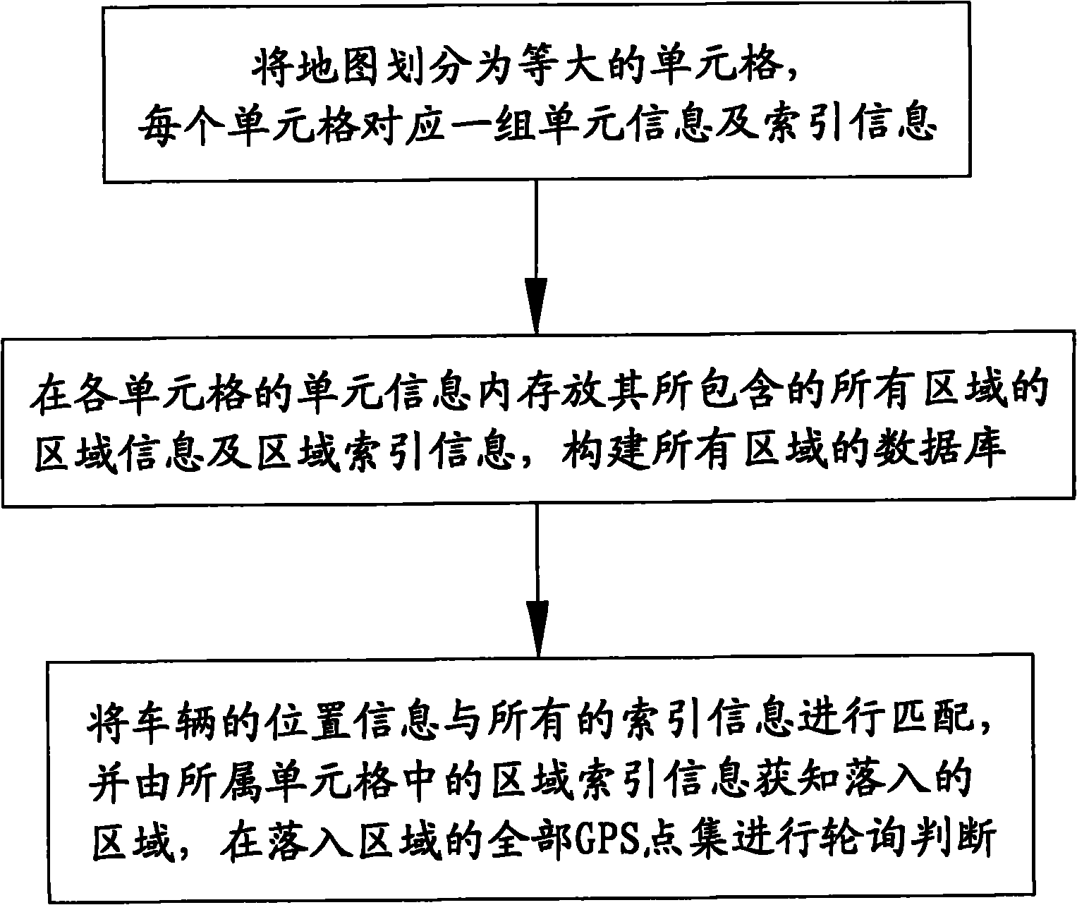
[0015] refer to figure 1 As shown, the present invention provides a method for quickly locating the area to which the vehicle belongs, comprising the following steps:

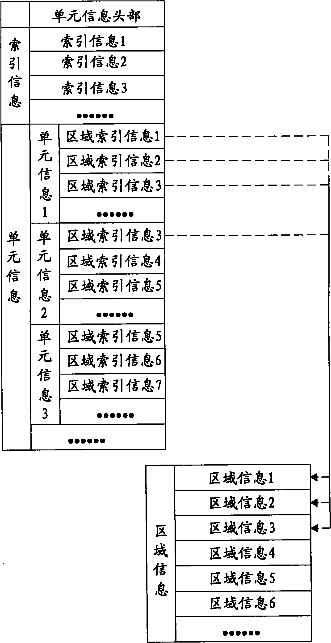
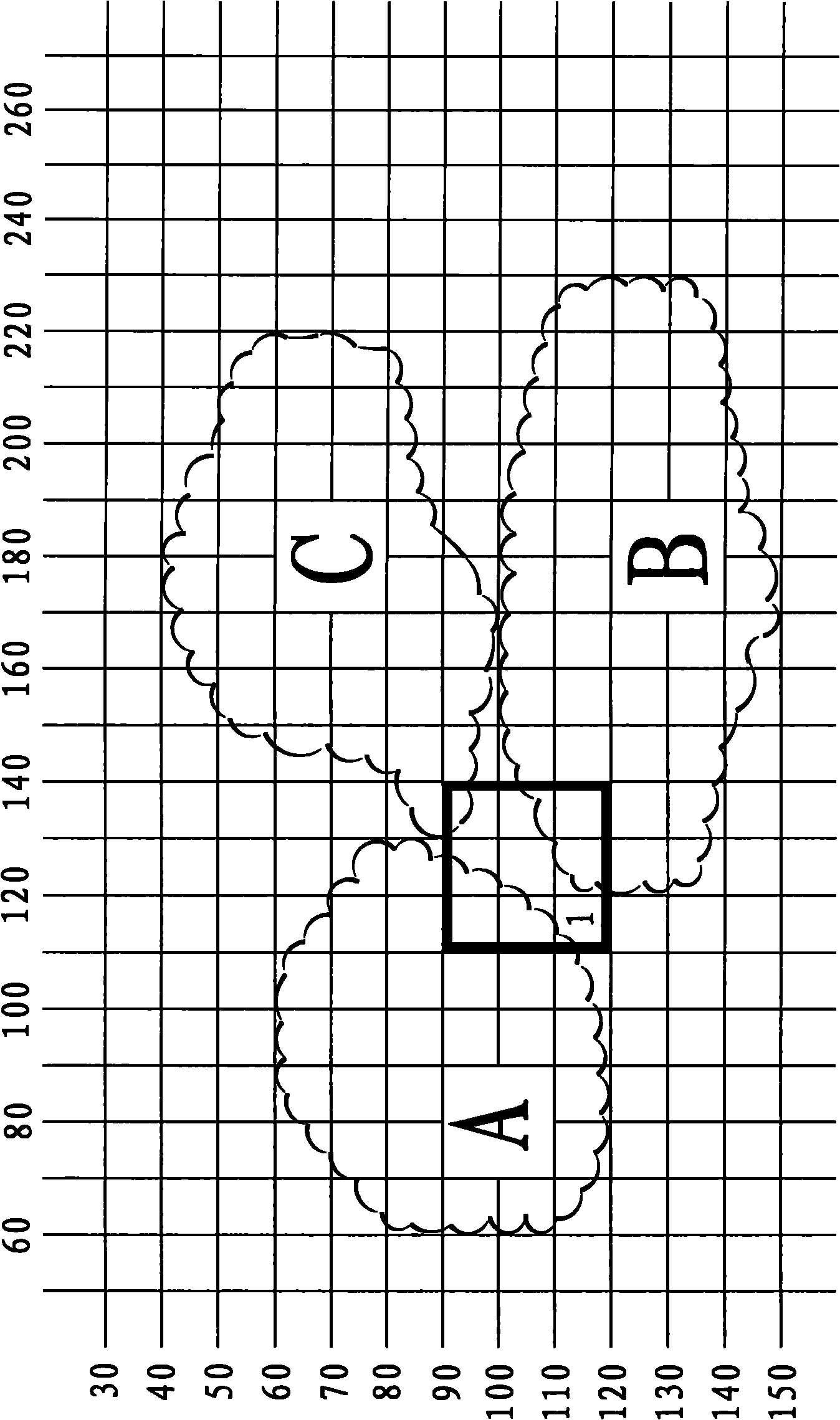
[0016] (1) Divide the map into multiple cells of equal size, which can be referred to at the same time image 3 As shown, in this embodiment, a cell with a span of 30 is formed as a unit of 30×30, of course, it can also be a rectangular cell; each cell corresponds to a set of unit information and index information to facilitate retrieval ;Usually the latitude and longitude range of the cell is used as the index information, taking cell 1 in the figure as an example, its index information is (110-140, 90-120); Area information and area index information of the area, the area information includes the area ID, all GPS point sets in the area and other configuration informati...


PUM


Abstract

The invention discloses a method for rapidly locating the current region of a vehicle, comprising the following steps: dividing a map into a plurality of equal table cells; dividing each region according to the corresponding table cell and numbering, wherein each table cell comprises IDs (identity), configuration information and region index information of all the regions contained in the table cell, and the region index information refers to the longitude and latitude ranges of one region; and during retrieval, firstly judging which table cell the vehicle is located in the map, then reading the region index information contained in the table cell, judging to determine the regions of which the index ranges conform to the current position, and then reading concrete GPS (global positioning system) point sets of the regions to carry out accurate adjustment. By adopting the method disclosed by the invention, purposive and planned region monitoring from large to small and from simple to complex is realized. Besides, the retrieval speed is faster, and the efficiency is higher.

Description

technical field [0001] The invention relates to a method for quickly determining the area to which a vehicle belongs during driving. Background technique [0002] According to a variety of management information, urban roads can be divided into different areas, and the shapes of these areas are mostly irregular, and the location information of these irregular areas is usually composed of multiple GPS points. GPS vehicle-mounted terminals often need to manage and apply access to road areas in accordance with specific industry applications, so as to better meet the needs of monitoring and management. The realization of GPS vehicle-mounted terminal area monitoring needs to judge the area surrounded by the connection lines of multiple GPS points. In this way, it is necessary to read and operate the information of multiple GPS points every time an area is judged. If the terminal actively judges the entry and exit of the area, it is necessary to save a large amount of area locati...

Claims


Application Information

Patent Timeline
Patent Type & Authority Applications(China)
IPC IPC(8): G08G1/127G06F17/30
Inventor 郑振贵黄雄栋唐磊陈义华
Owner XIAMEN YAXON NETWORKS CO LTD
Why Eureka
Try Eureka