Adaptive spatial clustering method

A spatial clustering and self-adaptive technology, applied in special data processing applications, instruments, electrical digital data processing, etc., can solve problems such as limiting application effects

Inactive Publication Date: 2011-08-24
CENT SOUTH UNIV
View PDF0 Cites 36 Cited by
  • Summary
  • Abstract
  • Description
  • Claims
  • Application Information

AI Technical Summary

Problems solved by technology

In addition, it is difficult for existing methods to perform spatial clustering analysis taking into account factors such as spatial proximity, similar thematic attributes, and spatial barriers, which undoubtedly limits its practical application effect

Method used


Image

  • Adaptive spatial clustering method
  • Adaptive spatial clustering method
  • Adaptive spatial clustering method

Examples


Embodiment 1

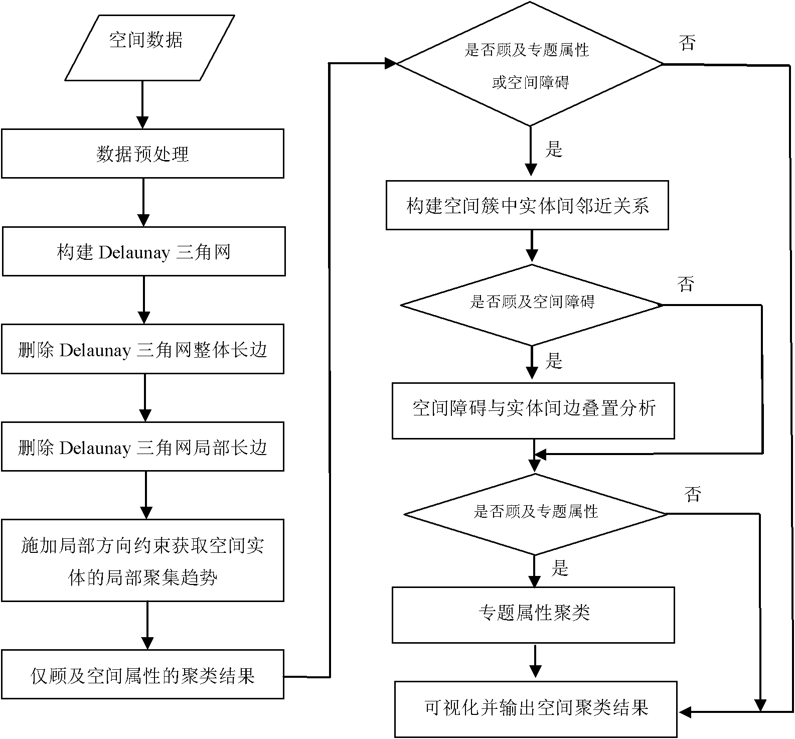
[0080] The specific embodiment of the present invention is made up of following several steps:

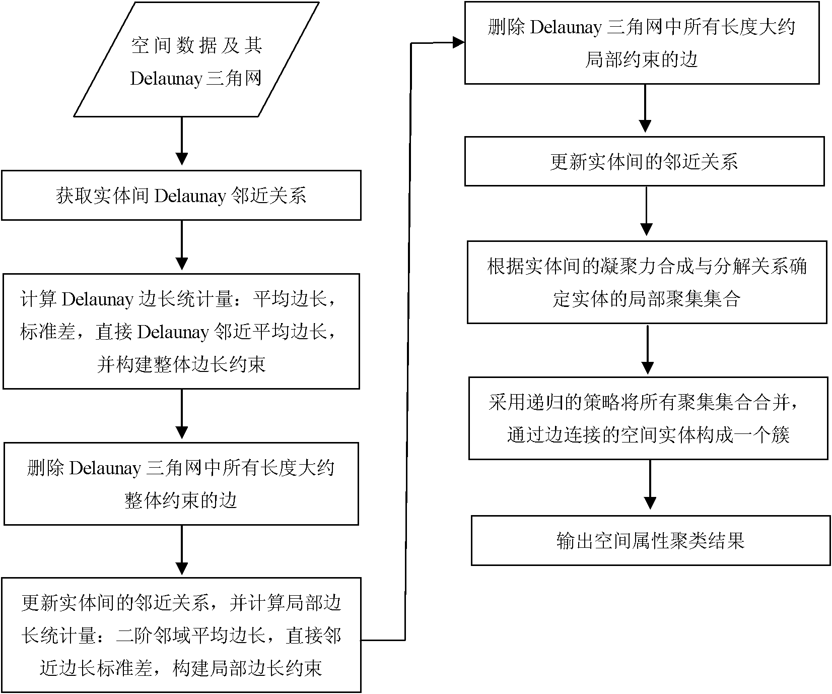
[0081] 1) Spatial data preprocessing and feature selection. Delaunay triangulation is a set of triangles connected by spatial entities but not overlapping, and the circumscribed circle of each triangle does not contain other spatial entities. In order to avoid errors when constructing the Delaunay triangulation, this step first preprocesses the spatial data, repairs or deletes the missing parts of the spatial data by means of spatial interpolation, and cleans up duplicate records. Reference may be made to the prior art; for the task of spatial clustering, that is, clustering attributes, the user selects specific spatial or thematic attributes and corresponding distance measurement criteria (such as Euclidean distance, Min's distance, Mahalanobis distance, etc.), and the specific Can refer to prior art.

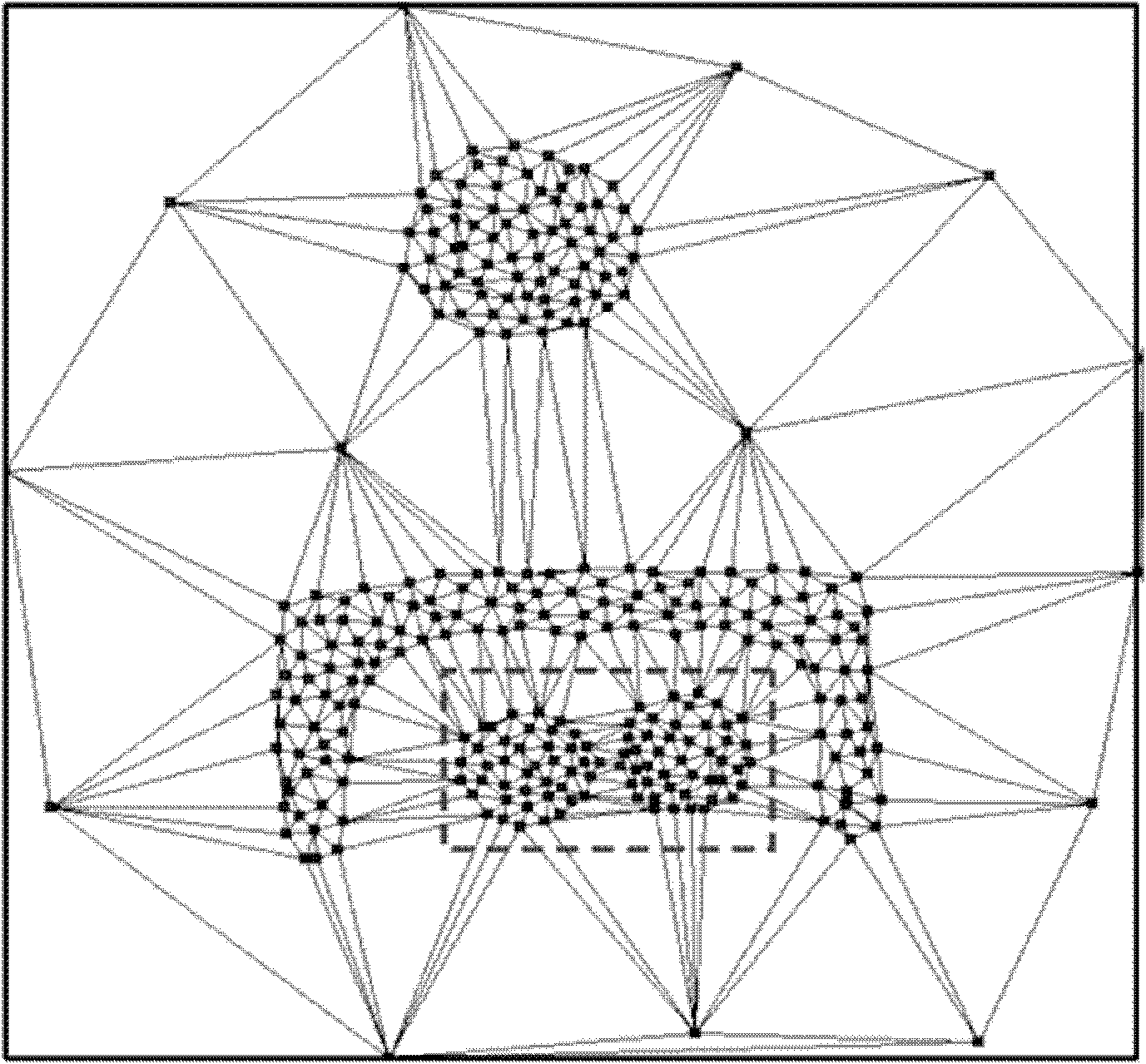
[0082] 2) Construct Delaunay triangulation to describe the spatial proximity...


PUM


Abstract

The invention discloses an adaptive spatial clustering method, comprising the following steps of: (1) preprocessing spatial data and selecting features; (2) creating a Delaunay triangulation network according to spatial attribute; (3) performing clustering analysis operations according to the spatial attribute; (4) turning to a step (5) if a spatial solid obstacle is needed to be further considered, and turning to a step (6) if a thematic attribute is needed to be considered, otherwise, ending the spatial clustering operations; (5) introducing a spatial obstacle layer, performing overlap analysis on the spatial obstacle and the side length of the Delaunay triangulation network between the entities in each spatial cluster, and breaking the side length if the spatial obstacle is intersected with the side length; (6) performing the thematic attribute clustering by an improved density-based spatial clustering method; (7) visualizing the clustering result, and outputting the clustering result. The adaptive spatial clustering method is simple and convenient to operate, high in degree of automation, high in calculation efficiency, perfect in functions, strong in applicability and the like, and can effectively improve capability of spatial clustering analysis to excavate deep-seated geoscience rules.

Description

technical field [0001] The invention belongs to the fields of spatial data mining and spatial analysis, and relates to an adaptive spatial clustering method. Background technique [0002] Spatial clustering is an important means of current geospatial data mining and knowledge discovery. It aims to divide the entities in the spatial database into a series of spatial clusters with a certain distribution pattern, so that the entities in the same spatial cluster have the greatest similarity. , the entities in different spatial clusters have the largest difference. At present, spatial clustering has been widely used in crime hotspot analysis, earthquake spatial distribution pattern mining, automatic cartography synthesis, remote sensing image classification, public facility location selection, land price evaluation, and spatiotemporal modeling and many other fields. [0003] The existing spatial clustering methods can be roughly divided into: (1) partition method; (2) hierarchic...

Claims


Application Information

Patent Timeline
Patent Type & Authority Applications(China)
IPC IPC(8): G06F17/30
Inventor 邓敏刘启亮黄健柏石岩
Owner CENT SOUTH UNIV
Why Eureka
Try Eureka