A Method for Analyzing the Effect of Landscape Features on the Accuracy of Remote Sensing Classification Spots

A classification map and feature pair technology, applied in image analysis, image data processing, instruments, etc., can solve the problems of only considering, error distribution difference, ignoring the shape characteristics of ground objects and spatial distribution structure characteristics, etc.

Inactive Publication Date: 2011-12-28
BEIJING NORMAL UNIVERSITY
View PDF0 Cites 18 Cited by
  • Summary
  • Abstract
  • Description
  • Claims
  • Application Information

AI Technical Summary

Problems solved by technology

However, these studies all take a single pixel as the research object, only considering the possible impact of the pixel position, ignoring the shape characteristics and spatial distribution structure characteristics of the ground object itself.
According to general experience, in the classification results of remote sensing, the shape and scale distribution of the classification map may cause a large difference in the error distribution.

Method used


Image

  • A Method for Analyzing the Effect of Landscape Features on the Accuracy of Remote Sensing Classification Spots
  • A Method for Analyzing the Effect of Landscape Features on the Accuracy of Remote Sensing Classification Spots
  • A Method for Analyzing the Effect of Landscape Features on the Accuracy of Remote Sensing Classification Spots

Examples


Embodiment Construction

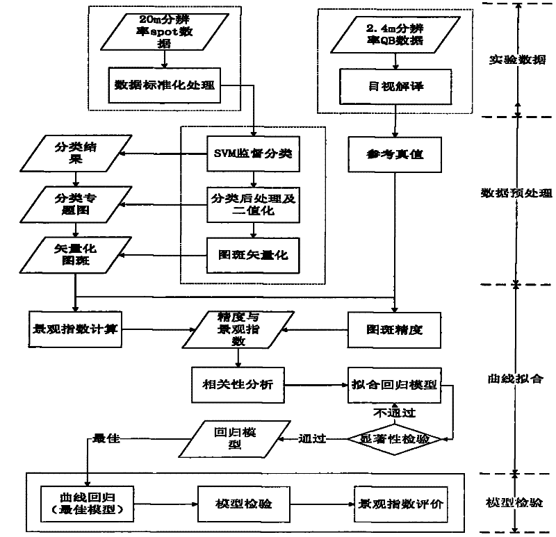
[0032] The present invention will be further described below in conjunction with the accompanying drawings and specific embodiments.

[0033] First, a brief description of the error distribution and the definition of landscape index in remote sensing classification is given. There are many factors that cause remote sensing classification accuracy and remote sensing classification error. The main error types include error caused by mixed pixels, classification type error error, and system error (operation error), etc. The model formula is expressed as follows:

[0034] ξ accuracy =F unction (E mixed-pixel ,E system ,E misclassification ,E others ) (1)

[0035] where: ξ accuracy Indicates the classification accuracy of remote sensing; E mixed-pixel Indicates the error caused by mixed pixels; E system Indicates the systematic error; E misclassification Indicates classification type error; Eothers Indicates other errors.

[0036] The present invention mainly studies ...


PUM


Abstract

The invention provides a method for analyzing the influence of landscape features on the precision of remote sensing classification spots, including step 1, acquiring data, including performing data standardization processing on original images; step 2, performing image recognition on the data obtained in step 1, including classifying and Post-classification processing, wherein the classification process includes the determination of the classification pattern; step 3, the correlation calculation between the classification pattern and the true value data pattern is carried out on the data obtained in step 2, and the regression curve fitting is established Regression model, including the definition of landscape index expressing landscape characteristics; step 4, statistically test the regression model established in step 3, and evaluate the classification error expressed by the landscape index. The present invention adopts the theoretical basis of the accuracy evaluation and analysis based on the spatial features of the remote sensing classification, uses the landscape features of the remote sensing classification map to describe and express the classification accuracy, and provides the basis and guidance for the application and research related to the land cover thematic map.

Description

【Technical field】 [0001] The invention relates to the field of remote sensing image classification, in particular to a method for analyzing and evaluating the influence of landscape features on the accuracy of remote sensing classification map spots. 【Background technique】 [0002] Remote sensing classification thematic maps are widely used in many fields, such as land cover / use change monitoring, animal habitat site selection, hydrological analysis, risk analysis, and natural resource surveys. They are often used to describe the spatial distribution and shape of land cover, estimate land Coverage and other aspects (Stehman and Czaplewski, 1998; Smith et al., 2002). The accuracy and error distribution of thematic maps directly affect the application range and effect of thematic maps (Foody, 2002; Smith et al., 2002; Smith et al., 2003). Therefore, it is of great significance to fully understand the source and spatial distribution range of land cover map errors for land cove...

Claims


Application Information

Patent Timeline
Patent Type & Authority Applications(China)
IPC IPC(8): G06K9/62G06T7/00
Inventor 张锦水潘耀忠金陆朱爽喻秋艳
Owner BEIJING NORMAL UNIVERSITY
Why Eureka
Try Eureka