Mobile navigation method for simultaneously attending to intersection broadcasting and point of interest (POI) explanation

A line and path technology, applied in the field of mobile tours, can solve the problems of no real-time guidance function and no real-time explanation function.

Active Publication Date: 2012-06-27
NANJING HANDSMAP INFOR TECH
View PDF13 Cites 2 Cited by
  • Summary
  • Abstract
  • Description
  • Claims
  • Application Information

AI Technical Summary

Problems solved by technology

The above method can only preview the multimedia information of scenic spots, and does not include the real-time explanation function; although this method provides tourists with a recommended tour route of the scenic spot, it has no real-time guidance function, which is undoubtedly a big problem for tourists who like self-guided tours and in-depth tours. Pity

Method used


Image

  • Mobile navigation method for simultaneously attending to intersection broadcasting and point of interest (POI) explanation
  • Mobile navigation method for simultaneously attending to intersection broadcasting and point of interest (POI) explanation
  • Mobile navigation method for simultaneously attending to intersection broadcasting and point of interest (POI) explanation

Examples


Embodiment

[0050] Basic requirements for mobile devices in this example: WindowsMobile 6.0 / 6.1 / 6.5 operating system; 480×800 pixel (or 240×320 pixel) resolution; single-core CPU frequency higher than 528MHz; memory not less than 512MB ROM+256MB RAM; support MicroSD card Extended storage, USB v2.0 and GPS navigation capabilities.

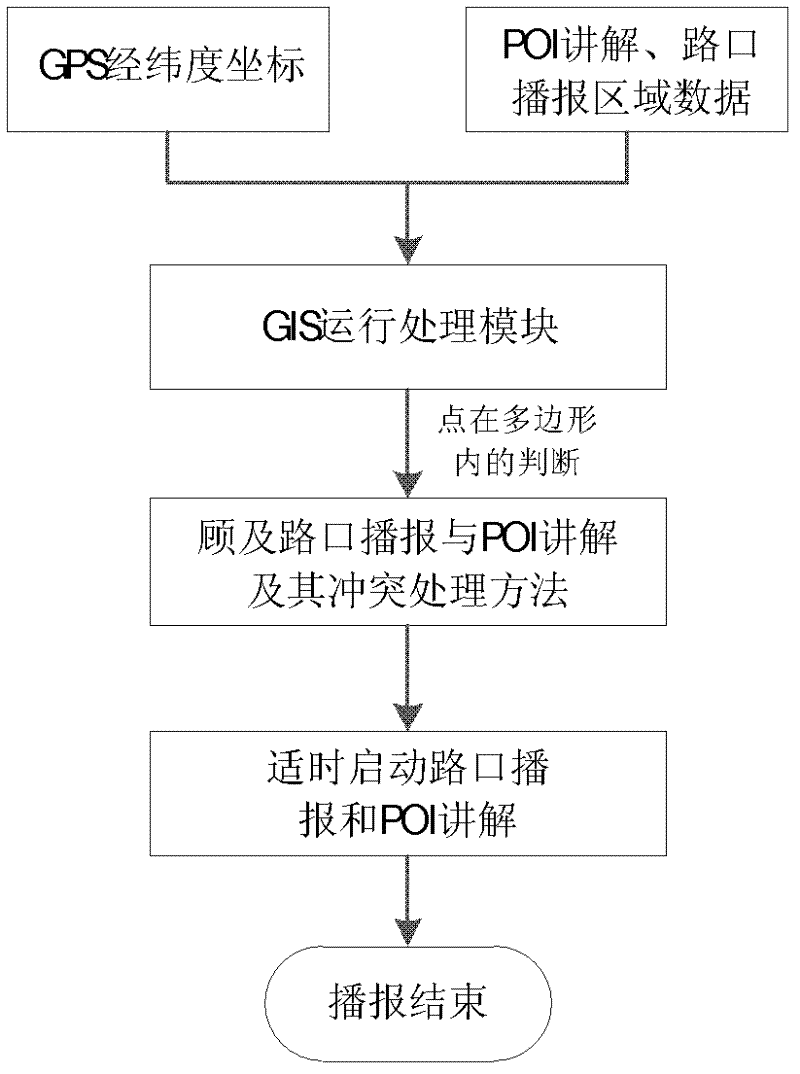
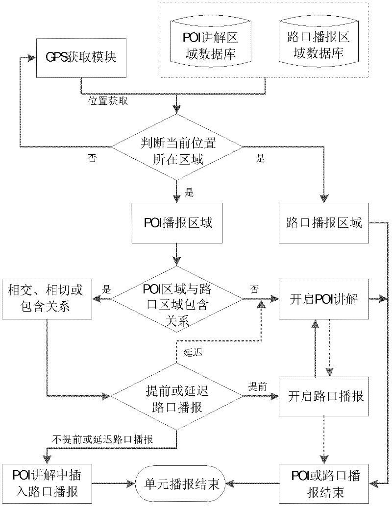
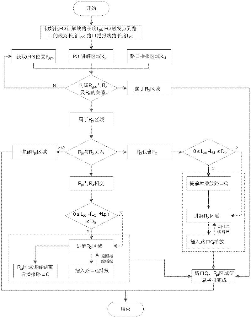
[0051] The GPS position acquisition module is provided by the GPS chip that comes with the mobile device. The geographic information system (GIS) module is based on the secondary development of ESRI's ArcGISMobile10 software. It directly drives the GPS chip device through the relevant interface to obtain information such as the current latitude and longitude position. The output of synthesized voice in the voice output module is realized by using the voice synthesis engine ejTTS6.0 and its interface of Jietong Huasheng Company, and the voice output based on audio broadcast is realized by using the Interop.WMPLib.dll file specially used for mobile devices provide...


PUM


Abstract

The invention discloses a mobile navigation method for simultaneously attending to intersection broadcasting and point of interest (POI) explanation, which relates to a geographic information system (GIS) technology, a global positioning system (GPS) technology and a voice multi-media technology. In order to resolve broadcasting conflicts occurring when intersection broadcasting and POI explanation are simultaneously attended to, the method disclosed by the invention mainly adopts the following steps that: when a user advances along a planned path, judgment is made; if the current position belongs to an intersection broadcasting area, intersection broadcasting is firstly started; and if the current position belongs to a POI explanation area, the space relationship between the intersectionbroadcasting area and the POI explanation area is firstly judged and is then combined with the distance relationship between trigger points of the two broadcasting areas, so as to timely broadcast the intersection information in advance or lingeringly. The mobile navigation method has the advantages that through adjusting the broadcasting time of intersection turning information, the consistency and the integrity of POI explanation are guaranteed while the intersection turning information is broadcast integrally and accurately.

Description

technical field [0001] The invention relates to a mobile navigation method and belongs to the technical field of geographic information systems (GIS). Background technique [0002] At present, the positioning technologies used in the mobile navigation system mainly include satellite positioning (including A-GPS positioning), wireless communication base station positioning, infrared positioning, ultra-wideband positioning, radio frequency identification positioning, Bluetooth positioning, Wi-Fi positioning, ZigBee positioning, etc. Among them, outdoor positioning mostly uses the GPS satellite positioning system of the United States. The mobile user terminal of the system has the advantages of small size, wide positioning range, free positioning, no need for additional hardware equipment support, and high relative positioning accuracy. a direction of development. [0003] With the continuous development of technologies such as vehicle navigation, pedestrian navigation, and l...

Claims


Application Information

Patent Timeline
IPC IPC(8): G09F25/00
Inventor 龙毅余明朗贾倩
Owner NANJING HANDSMAP INFOR TECH
Why Eureka
Try Eureka