SRG (sphere rhombus grid) subdivision code and geographic coordinate converting algorithm

A technique for subdividing codes and geographic coordinates, which is applied in the field of conversion algorithms and can solve problems such as insufficient conversion accuracy

Inactive Publication Date: 2012-07-11
NAT UNIV OF DEFENSE TECH
View PDF2 Cites 11 Cited by
  • Summary
  • Abstract
  • Description
  • Claims
  • Application Information

AI Technical Summary

Problems solved by technology

"Row-column approximation method" only applies simple arithmetic operations of addition, subtraction, multiplication and divi

Method used


Image

  • SRG (sphere rhombus grid) subdivision code and geographic coordinate converting algorithm
  • SRG (sphere rhombus grid) subdivision code and geographic coordinate converting algorithm
  • SRG (sphere rhombus grid) subdivision code and geographic coordinate converting algorithm

Examples


Embodiment Construction

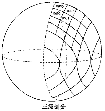
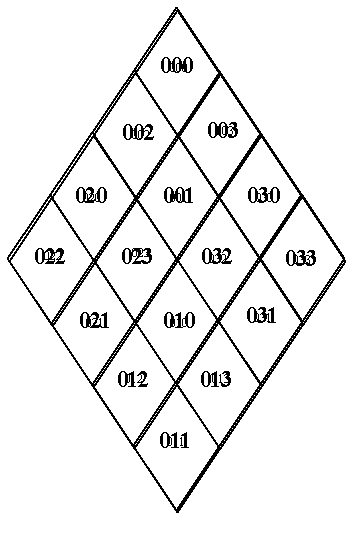
[0104] Examples of conversion between latitude and longitude coordinates and SRG subdivision address codes

[0105] Conversion of SRG codes to latitude and longitude coordinates

[0106] For example, the quadrilateral numbered 0012301 is generated by 6-level subdivision, and its latitude is recorded as w 0112301 , longitude recorded as j 0012301 , the calculation process is as follows:

[0107] w 0012301 =w 001230 -45 / 5 5

[0108] =w 00123 +45 / 24 -45 / 2 5

[0109] =w 0012 +45 / 2 4 -45 / 2 5

[0110] =w 001 +45 / 2 4 -45 / 2 5

[0111] =w 00 -45 / 2+45 / 2 4 -45 / 2 5

[0112] =45-45 / 2+45 / 2 4 -45 / 2 5

[0113] =24.25

[0114] j 001 =1×(90 / 3)+45 / 3

[0115] j 0012 =2×(90 / 6)+45 / 6

[0116] j 00123 =5×(90 / 12)+45 / 12

[0117] j 001230 =10×(90 / 23)+45 / 23

[0118] j 0012301 =21×(90 / 47)+45 / 47=41.17

[0119] Conversion of latitude and longitude coordinates to SRG code

[0120] Given the latitude and longitude coordinates (...


PUM


Abstract

The invention relates to an SRG (sphere rhombus grid) subdivision code and geographic coordinate converting algorithm, which is based on the SRG subdivision method. The SRG subdivision code and geographic coordinate converting algorithm inherits the advantages of the SRG subdivision method, SRG address codes have constant directivity and are favorable for proximity searching, no projection conversion is involved in the SRG subdivision method and no projection is involved during conversion, simple arithmetic operations of addition, subtraction, multiplication and division are involved during computing, and computing speed is high. Besides, rhombus blocks hard to differentiate are differentiated by the aid of the coordinate system, and conversion accuracy is increased.

Description

technical field [0001] The invention relates to a conversion algorithm between subdivision coding and latitude and longitude coordinates based on the SRG subdivision method. Background technique [0002] At present, the vast majority of spherical geographic data is based on latitude and longitude coordinates. In the SRG structure, the grid coordinates are implicitly expressed by address codes. The data information in is mapped to the traditional latitude and longitude coordinates, in order to conform to people's thinking habits, the mutual conversion between these two address codes must be realized. [0003] Sphere Rhombus Grid (SRG) is a subdivision method based on geographic coordinates combined with latitude and longitude and using the idea of ​​regular polyhedron recursion step by step to directly subdivide the spherical surface. [0004] At present, the vast majority of spherical geographic data is based on latitude and longitude coordinates. In the SRG structure, the ...

Claims


Application Information

Patent Timeline
IPC IPC(8): G06F17/30
Inventor 徐晖聂洪山孙兆林徐欣刁节涛张玉梅
Owner NAT UNIV OF DEFENSE TECH
Why Eureka
Try Eureka