Spatial index generating method and graphical object displaying method

A graphic object, spatial indexing technology, used in special data processing applications, instruments, electrical digital data processing, etc.

Inactive Publication Date: 2013-04-17
SKYEYES GPS TECH
View PDF1 Cites 4 Cited by
  • Summary
  • Abstract
  • Description
  • Claims
  • Application Information

AI Technical Summary

Problems solved by technology

[0006] The object of the present invention is to provide a method for generating a spatial index and a method for displaying graphic objects of spatial data, so as to solve the problem of how to improve the search efficiency of graphic objects in spatial data and moderately reduce the storage space required by the spatial index

Method used


Image

  • Spatial index generating method and graphical object displaying method
  • Spatial index generating method and graphical object displaying method
  • Spatial index generating method and graphical object displaying method

Examples


Embodiment Construction

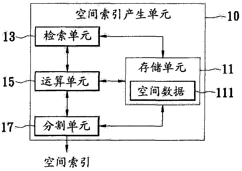
[0028] Please refer to figure 1 , figure 1 A block diagram of one embodiment of a system for generating a spatial index. The spatial index generating system 10 includes a storage unit 11 , a retrieval unit 13 , a computing unit 15 and a segmentation unit 17 . The storage unit 11 is electrically connected to the retrieval unit 13 , the operation unit 15 and the division unit 17 , and the operation unit 15 is electrically connected to the retrieval unit 13 , the storage unit 11 and the division unit 17 . The above-mentioned spatial index generation system may be an electronic device that executes software or program codes to control hardware, such as various computer systems, but the present invention is not limited thereto.

[0029] In one embodiment, the storage unit 11 stores spatial data 111 (spatial data) of a geographic information system (Geographic Information System, GIS). The spatial data 111 records graphical objects related to geographical entities and data of som...


PUM


Abstract

The invention provides a spatial index generating method which is used for building spatial indexes of spatial data. The method includes: reading total number of objects contained in the spatial data, operating according to the total number of the objects and preset division units to obtain division number, dividing the spatial data into a plurality of spatial areas according to the division number, and generating spatial indexes according to at least one graph in the spatial areas or the spatial data. Through the method, storage space occupied by the generated spatial indexes can be controlled to be in an appropriate range, the generated spatial indexes are used for searching graphical objects of the spatial data, and time required by searching and processing can be reduced appropriately.

Description

technical field [0001] The invention designs a method for generating an index, in particular a method for generating a spatial index and a method for displaying graphic objects of spatial data. Background technique [0002] Map is a kind of graphic data. It is a tool for describing space things on the surface of the earth. With the advancement of science and technology and the rapid development of information exchange and transmission, human activities have become more complex and extensive. Therefore, the requirements for the meaning and presentation of maps will be Even more elevated. Therefore, it is an increasingly important subject to control and manipulate the performance of each point, line and surface on the map. [0003] In response to the above needs, Geographic Information System (GIS) came into being. Geographic information system is a science under the integration of technology, which integrates geographic mathematics, map measurement and computer science. Da...

Claims


Application Information

Patent Timeline
Patent Type & Authority Applications(China)
IPC IPC(8): G06F17/30
Inventor 许以龙方耀民周天颖
Owner SKYEYES GPS TECH
Why Eureka
Try Eureka