
Engineering application method of extracting traffic road data from electronic map

A technology for electronic maps and road data, applied in special data processing applications, electrical digital data processing, instruments, etc., can solve the problems of poor application of multi-scale electronic maps, difficult development, time-consuming and laborious, etc., to save The cost of data collection, the improvement of design efficiency, and the effect of high operating efficiency

Active Publication Date: 2016-06-29
CHINA RAILWAY SIYUAN SURVEY & DESIGN GRP
View PDF1 Cites 0 Cited by
  • Summary
  • Abstract
  • Description
  • Claims
  • Application Information

AI Technical Summary

Problems solved by technology

If you want to obtain these enhanced road elements, there are two methods in the past: 1. Manual tracking and digital extraction; 2. Image-based pattern recognition extraction. The electronic map of the scale is not very applicable

Method used


Image

  • Engineering application method of extracting traffic road data from electronic map

Examples


Embodiment Construction

[0010] The present invention will be further described in detail below in conjunction with the accompanying drawings and embodiments.

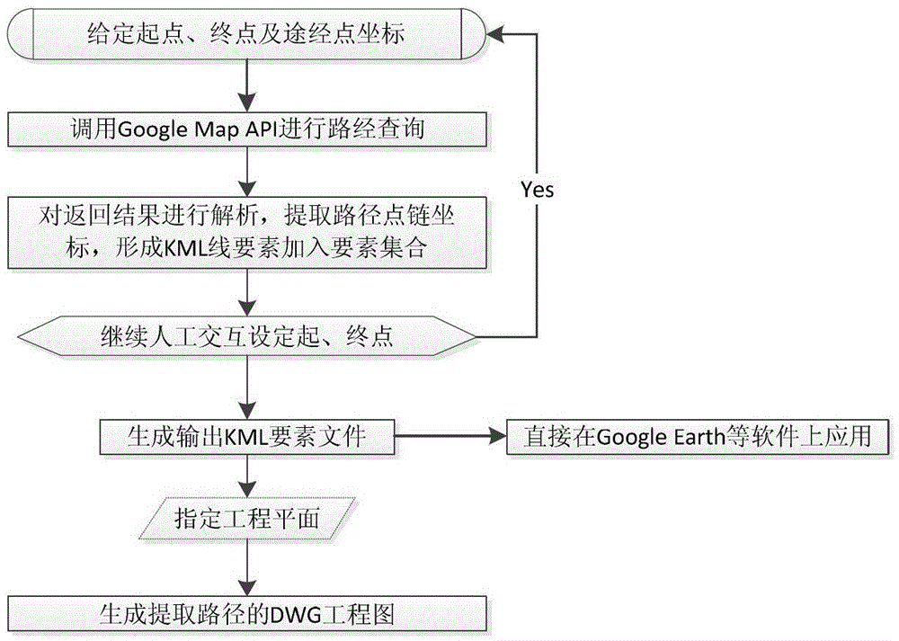
[0011] The invention realizes the semi-interactive vector traffic map data collection, automatic conversion and project map output under any project plane through the route query function API function of GoogleMaps. When extracting roads, you only need to select the starting point and end point of the route on the network map and optionally input the route points, and then you can accurately obtain the XML data of the road information through API route query, and analyze the vertices of the route through the XML data That is, the KML element output of the path can be formed, and at the same time, the invention provides the DWG engineering drawing file that the KML file can be transformed into any coordinate system. The specific steps are:

[0012] 1. Extract digitized vector elements from GoogleMaps and output KML files: through the route que...


PUM


Abstract

The invention relates to an engineering application method of collecting traffic road data from an electronic map. The method includes the following steps: collecting traffic road data from a network electronic map through route query, route analysis and coordinate transformation; and writing the data into a newly established DWG engineering drawing document of Auto Computer Aided Design (AutoCAD) one by one according to engineering plane positions to accomplish the application from the network electronic map to an electronic engineering drawing. The engineering application method of collecting the traffic road data from the electronic map has the advantages of being faster in data updating, strong in up-to-date state, easy to operate, accurate in factor positioning, high in operation efficiency and the like for automatic collection and engineering application of the traffic road data. The engineering application method of collecting the traffic road data from the electronic map is a feasible, zero-cost and efficient data acquisition method on the condition that a road vector diagram is absent or a vector diagram of a newly-built road needs to be supplemented, provides data sources for engineering design and other applications, saves data acquisition cost, and improves design efficiency.

Description

technical field [0001] The invention belongs to the technical field of engineering design, in particular to an engineering application method for extracting traffic road data from an electronic map. Background technique [0002] In engineering design, the lack of newly-built traffic roads in the obtained topographic map often leads to poor consideration of the design results, and the electronic map service provider will present the newly-built roads on the electronic map in a more timely manner. Provide more comprehensive navigation services. If you want to obtain these enhanced road elements, there are two methods in the past: 1. Manual tracking and digital extraction; 2. Image-based pattern recognition extraction. The former is time-consuming and laborious, while the latter is difficult to develop and has a poor recognition rate. The applicability of scaled electronic maps is not strong. Contents of the invention [0003] The purpose of the present invention is to prov...

Claims


Application Information

Patent Timeline
Patent Type & Authority Patents(China)
IPC IPC(8): G06F17/50
Inventor 韩元利李朝锋周德宏南学元彭先宝
Owner CHINA RAILWAY SIYUAN SURVEY & DESIGN GRP
Learn More