AR (augmented reality)-based vehicle-mounted live-action safe navigation method

A technology of augmented reality and navigation method, which is applied to road network navigators, vehicle components, optical observation devices, etc., can solve problems such as inability to recognize images, and achieve user-friendly effects

Active Publication Date: 2013-05-15
四川长虹佳华信息产品有限责任公司
View PDF5 Cites 83 Cited by
  • Summary
  • Abstract
  • Description
  • Claims
  • Application Information

AI Technical Summary

Problems solved by technology

[0002] At present, many cars are equipped with cameras at the front. The cameras collect images of the foreground of the car and display them on the screen in the car, but they cannot recognize the images and only provide real-time image information to the driver. According to the virtual map through satellite positioning, the position of the car on the virtual map can be given on the virtual map, and although many high-end cars are equipped with proximity sen

Method used


Image

  • AR (augmented reality)-based vehicle-mounted live-action safe navigation method
  • AR (augmented reality)-based vehicle-mounted live-action safe navigation method
  • AR (augmented reality)-based vehicle-mounted live-action safe navigation method

Examples


Embodiment Construction

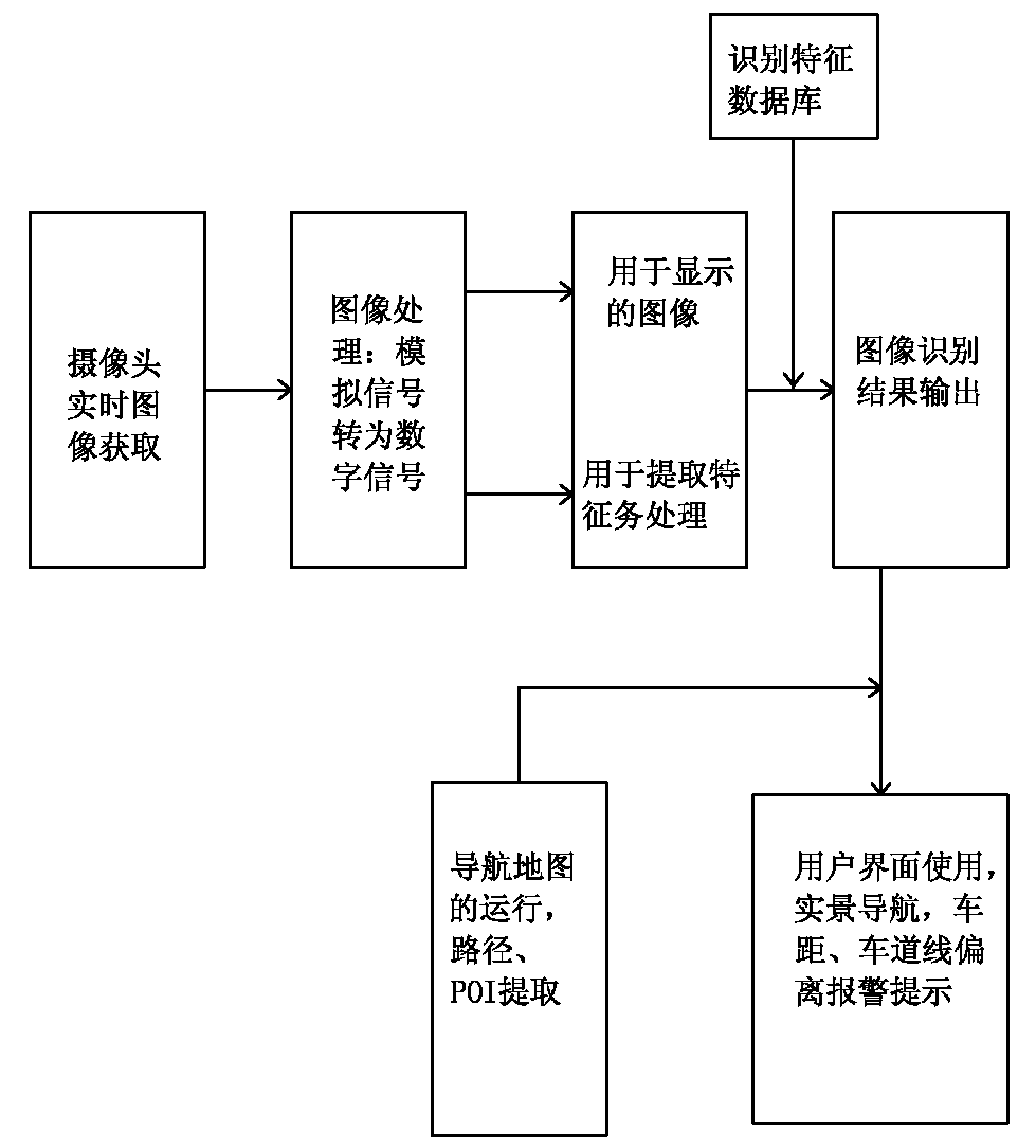
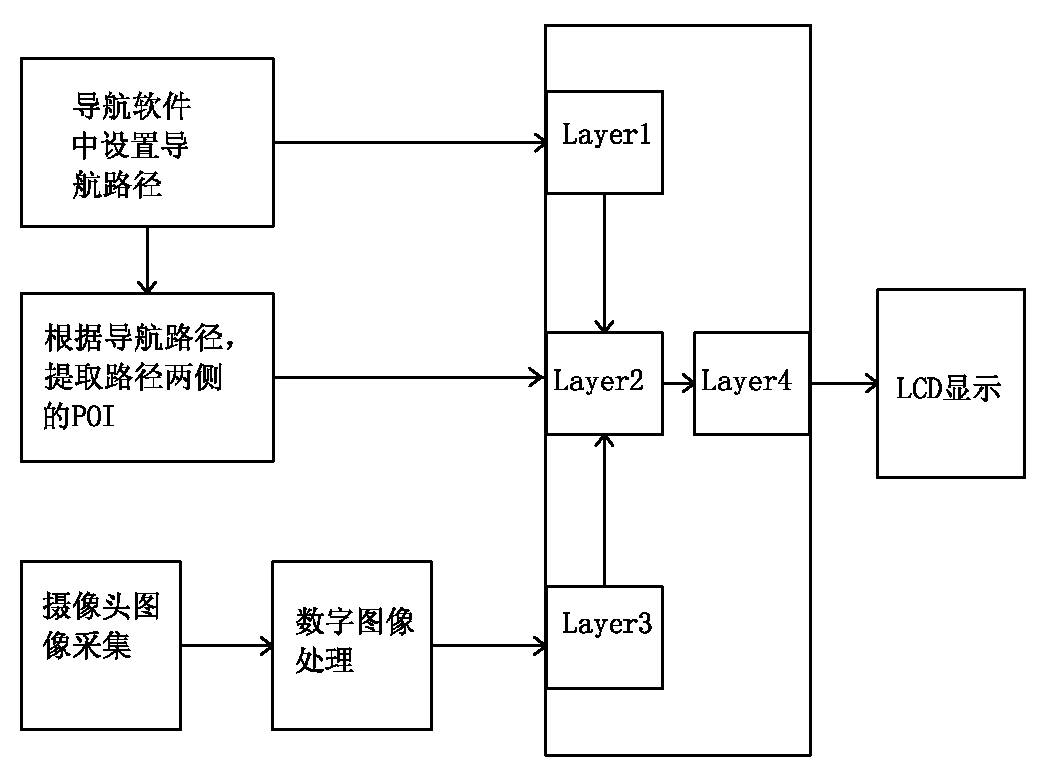
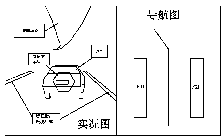
[0022] An embodiment of a vehicle real-scene safety navigation method based on AR augmented reality technology. Augmented reality (Augmented Reality, referred to as AR), also known as mixed reality, refers to the fusion of virtual 3D and real images through image processing technology to make the real environment Superimposed on the same picture or space with the virtual world in real time. see figure 1 , figure 2 and image 3 , the system of the method includes a camera set at the front of the car and a vehicle-mounted device connected thereto, wherein the vehicle-mounted device includes a satellite navigation system and a database of features for identifying object features, and also includes a connection between the object and the vehicle. The alarm threshold value table of correlation, the step that described method executes comprises:

[0023] a. Collect real-time images in front of the vehicle, perform feature extraction processing on objects in the real-time images,...


PUM


Abstract

The invention relates to an AR (augmented reality)-based vehicle-mounted live-action safe navigation method which comprises the following steps of: acquiring a real-time image in front of a vehicle, carrying out characteristic object extracting treatment on the real-time image, and overlapping an object image attached with a recognition feature with the real-time image; extracting real-time navigation cartographic information from a satellite navigation map for overlapping to form a second image with the navigation information; and when one object attached with the recognition feature in the image triggers an alarm threshold value, promoting a driver to drive on an optimal safety route by an alarm image or sound. The method has the advantages that a novel navigation method which combines cartographic navigation software with the AR (augmented reality) technology can be realized, and a destination can be conveniently found; the destination can be combined with the live-action due to the live-action navigation provided by the invention, the destination is identified on the live-action, and the method is more convenient for users; and the distance between front and back vehicles can be displayed timely, and the deviation from a lane line can be prompted, thereby assisting in safe driving.

Description

technical field [0001] The present invention relates to the field of wireless navigation, in particular to a vehicle-mounted real-scene safety navigation method based on AR augmented reality technology, which uses a vehicle-mounted front camera to prompt the user for lane lines, obstacles and distances to target obstacles and navigates on real-time images The superposition of information provides users with a safe driving path on the basis of navigation for users. technical background [0002] At present, many cars are equipped with cameras at the front. The cameras collect images of the foreground of the car and display them on the screen in the car, but they cannot recognize the images and only provide real-time image information to the driver. According to the virtual map through satellite positioning, the position of the car on the virtual map can be given on the virtual map, and although many high-end cars are equipped with proximity sensors to provide a safety reminder...

Claims


Application Information

Patent Timeline
IPC IPC(8): G01C21/34G01C21/36B60R1/00
Inventor 吕童群
Owner 四川长虹佳华信息产品有限责任公司
Why Eureka
Try Eureka