Method and device for determining the position of a vehicle on a carriageway and motor vehicle having such a device

A technology for vehicles and automobiles, which is applied to vehicle components, satellite radio beacon positioning systems, measuring devices, etc., can solve the problem of unavailability, and achieve the effect of accurate driving instructions, simple and reliable vehicle navigation

Active Publication Date: 2013-05-15
AUDI AG
View PDF10 Cites 27 Cited by
  • Summary
  • Abstract
  • Description
  • Claims
  • Application Information

AI Technical Summary

Problems solved by technology

The accuracy of the determination of the vehicle's position via satellite navigation is therefore only appr...

Method used


Image

  • Method and device for determining the position of a vehicle on a carriageway and motor vehicle having such a device
  • Method and device for determining the position of a vehicle on a carriageway and motor vehicle having such a device
  • Method and device for determining the position of a vehicle on a carriageway and motor vehicle having such a device

Examples


Embodiment Construction

[0059] In the figures, identical or functionally identical elements are provided with the same reference signs.

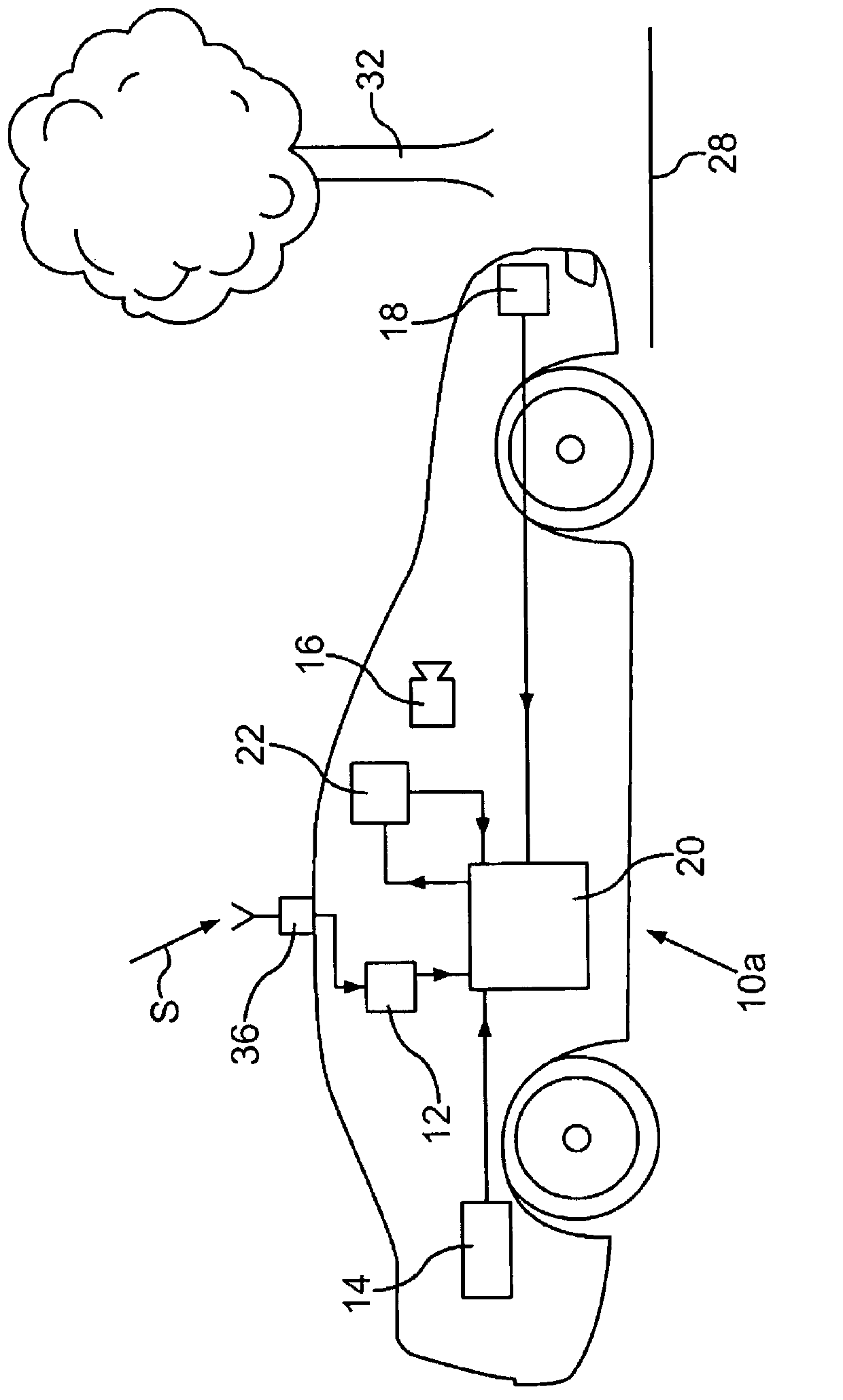
[0060] The car 10a is equipped with a device for determining the position of the vehicle. The device comprises a digital map 12 , a driving dynamics sensor 14 , an environment sensor 16 , a line recognition sensor 18 , a satellite signal sensor 36 and a position determination unit 20 . Satellite signal sensor 36 receives satellite signals S via an antenna and thereby determines the position of motor vehicle 10a with a first accuracy. The data is output or the signal is transmitted to the digital map 12 in which the ascertained position is coordinated with the navigation map data. The digital map 12 is stored on a data memory. For the corresponding position, map data attributes are provided in the digital map, which provide information about the environment of the vehicle. Said data are transmitted to the position determination unit 20 . As an alternative, it ca...


PUM


Abstract

The invention relates to a method for determining the position of a vehicle (10a) on a carriageway (24), in which method data of a satellite signal sensor (36), of a digital map (12), of a line detection sensor (18) and of a vehicle movement dynamic sensor (14) and/or of a surroundings sensor (16) are combined in such a way that the position of the vehicle (10a) on the carriageway (24) is determined with at least lane-specific accuracy. In particular, the method can also be used to determine the number of lanes. The invention also relates to a device for determining the position of a vehicle (10a) on a carriageway (24) and to a motor vehicle having such a device.

Description

technical field [0001] The invention relates to a method for determining the position of a vehicle on a road and to a device for said method. Furthermore, the invention relates to a motor vehicle having such a device. Background technique [0002] Electronic navigation systems support vehicle drivers in navigating their vehicles on the appropriate route from origin to destination. The global position of the vehicle is usually ascertained by satellite signal sensors, for example GPS (Global Positioning System) sensors, and displayed on a map on a display. The positioning of the vehicle on the schematically represented road takes place via the GPS position in conjunction with suitable map matching methods. The accuracy of the determination of the vehicle's position via satellite navigation is therefore only approximately 20 m, so that, for example, the vehicle's position on the road cannot be accurately described by a lane. The number of lanes on the road that can be expect...

Claims


Application Information

Patent Timeline
IPC IPC(8): G01C21/30G01S11/12G01S19/47B60W30/18
CPCG01S19/47B60W30/18163G01C21/30B60W2520/10G01S11/12B60W2550/141G01C21/3602B60W2550/146B60W30/12B60W2550/402B60W2552/30B60W2552/05B60W2556/50G01C21/3658
Inventor C·西蒙
Owner AUDI AG
Why Eureka
Try Eureka