Method based on NTRIP for measuring RTD of arbitrary coordinate system result

A technology of coordinate system and target coordinate system, applied in the field of geodetic surveying and satellite navigation, which can solve the problems of complex data processing, high user quality requirements, and lack of real-time performance.

Inactive Publication Date: 2013-09-11
WUHAN UNIV
View PDF5 Cites 9 Cited by
  • Summary
  • Abstract
  • Description
  • Claims
  • Application Information

AI Technical Summary

Problems solved by technology

[0014] In order for the user to obtain the coordinates of the ginseng coordinate system, there are three conventional methods: 1) The user submits the measured ECEF coordinates in written form to the surveying and mapping results storage unit approved by the State Bureau of Surveying and Mapping, and the latter coordinates after the approval. Conversion, and the result will be sent back to the user. This mode has good confidentiality, and the accuracy and reliability of the results are guaranteed, but the procedure is cumbersome, the work efficiency is low, and it is not real-time, which cannot meet the needs of real-time stakeout ginseng coordinate system coordinates
2) The surveying and mapping results storage unit approved by the State Bureau of Surveying and Mapping establishes a coordinate conversion network service system [2] [3], authorized users can submit the measured ECEF coordinates online through the network, and the service system will feedback the results through the network after completing the coordinate conver

Method used


Image

  • Method based on NTRIP for measuring RTD of arbitrary coordinate system result
  • Method based on NTRIP for measuring RTD of arbitrary coordinate system result
  • Method based on NTRIP for measuring RTD of arbitrary coordinate system result

Examples


Embodiment Construction

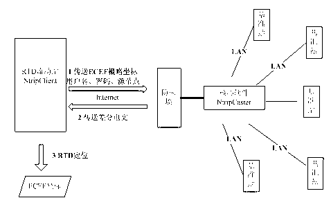
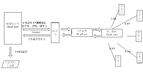
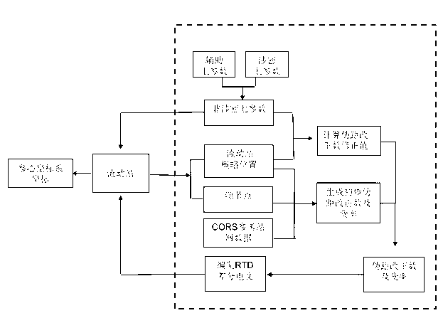
[0075] The arbitrary coordinate system described in the present invention includes arbitrary ECEF (such as WGS84, ITRS, PE-90, CGCS2000, etc.), arbitrary ginseng coordinate system (such as 1954 Beijing coordinate system, 1980 Xi'an coordinate system, new 1954 Beijing coordinate system, etc.) and Any elevation system (such as Baltic Sea elevation, Wusong elevation system, Guangzhou elevation, Pearl River elevation, 1956 Yellow Sea elevation system, 1985 national elevation datum, geodetic height, etc.) is implemented in the same way. The technical solution of the present invention will be described in detail below in conjunction with the drawings and embodiments.

[0076] In the example, a certain province has established a CORS system with 100 reference stations. NtripCaster uses the GPSNet software developed by Trimble, and the directly measured coordinates belong to WGS84, and the conversion parameters from WGS84 to ginseng coordinate system coordinates are top secret. The ce...


PUM


Abstract

A method based on NTRIP for measuring an RTD of an arbitrary coordinate system result carries out extension on a source node, is used for conveying moving station requests with details, does not need to modify NTRIP, and simply needs to add judgments and algorithms to NtripCaster software, or adds an NtripProxy relay module between NtripCaster and a moving station. A coordinate under a reference-ellipsoid-centric coordinate system needs to be acquired in real time, a corresponding source node simply needs to be selected when a server is logged in, and non-secret seven parameters are filled in a handhold notebook. If normal height needs to be acquired in real time, a corresponding source node simply needs to be selected when the server is logged in. If ECEF coordinate needs to be obtained in real time, a corresponding source node simply needs to be selected when the server is logged in. An operating mode is basically unchanged, under the premise that a privacy policy is met, the reference-ellipsoid-centric coordinate system and the normal height of real-time survey staking of the RTD can be achieved, and surveying and mapping production efficiency is remarkably improved.

Description

technical field [0001] The invention relates to the fields of geodetic surveying and satellite navigation, in particular to an RTD method for measuring results of an arbitrary coordinate system based on NTRIP. Background technique [0002] RTD (Real Time Pseudorange Difference) is an application of GNSS (Global Navigation Satellite System). Its system consists of several reference stations and rover stations that are relatively close (usually less than 100km). The coordinates are known precisely. Since there is a strong error correlation between the pseudorange code observations received by the reference station and the rover at the same time, the pseudorange correction number and its change rate are sent from the reference station to the rover, and then the pseudorange differential positioning is performed. It can eliminate or weaken public satellite ephemeris errors, satellite clock errors, ionospheric errors, and tropospheric errors, and realize real-time positioning of ...

Claims


Application Information

Patent Timeline
IPC IPC(8): G01S19/42
Inventor 章迪郭际明巢佰崇罗年学
Owner WUHAN UNIV
Why Eureka
Try Eureka