Landscape-planning-oriented image acquisition method for accurate space positioning

A technology for precise positioning and image acquisition, used in measuring devices, instruments, surveying and navigation, etc.

Active Publication Date: 2013-10-02
SOUTHEAST UNIV
View PDF5 Cites 4 Cited by
  • Summary
  • Abstract
  • Description
  • Claims
  • Application Information

AI Technical Summary

Problems solved by technology

Some scenic spots are displayed through some photos of some viewing spots, but they cannot fully reflect the overall situation
The above several methods have the following disadvantages compared with the image acquisition technology based on GPS space precise positioning of the present invention: from the data accuracy, based on the LBS base station positioning of mobile phones and the GPS positioning based on instruments and the three-dimensional GPS of scenic spots Positioning has the characteristics of insufficient accuracy. The error of LBS base station positioning ranges from 500-5000 meters, and the error of GPS positioning is within 5-10 meters. The error of 5-10 meters in the scenic spot will lead to complete differentiation of the route
The problem of how tourists choose their own routes based on real photos has the disadvantages of strong subjectivity and difficult operation. It is necessary to provide an image acquisition technology for landscape planning and precise spatial positioning

Method used


Image

  • Landscape-planning-oriented image acquisition method for accurate space positioning
  • Landscape-planning-oriented image acquisition method for accurate space positioning
  • Landscape-planning-oriented image acquisition method for accurate space positioning

Examples


Embodiment Construction

[0030] The present invention will be further clarified below in conjunction with the drawings and specific embodiments. It should be understood that these embodiments are only used to illustrate the present invention and not to limit the scope of the present invention. After reading the present invention, those skilled in the art will modify various equivalent forms of the present invention to fall within the appended claims of this application. The limited range.

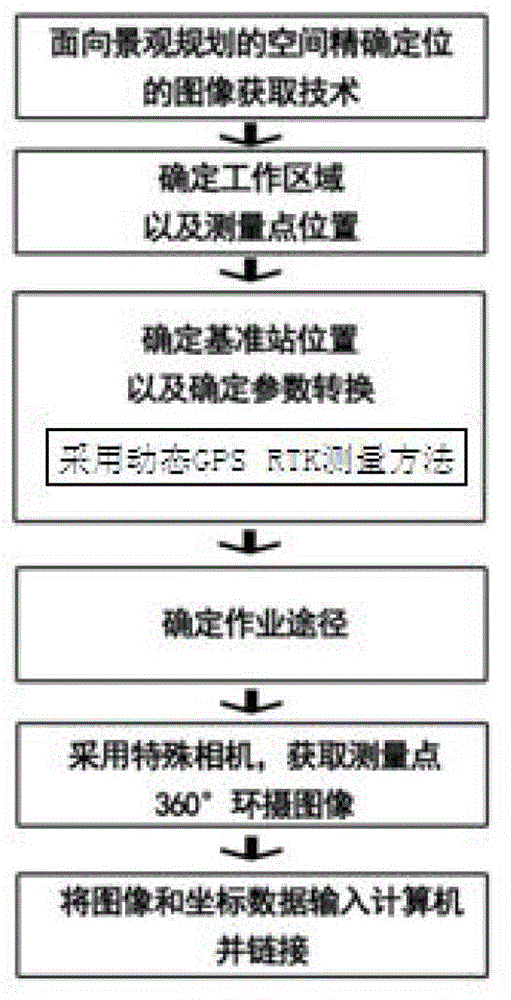
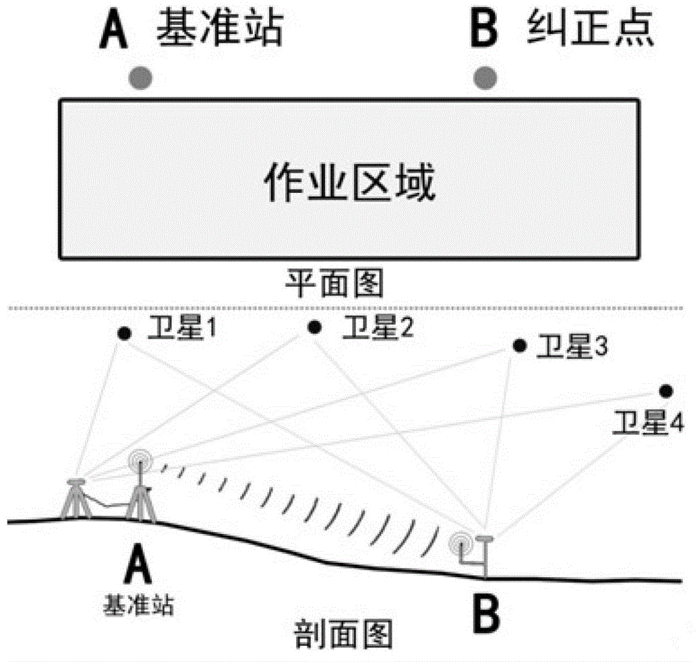
[0031] The present invention adopts GPS-RTK technology as a supporting means. GPS-RTK technology is an efficient positioning technology. It uses more than two GPS receivers to simultaneously receive satellite signals with an error of centimeter level. Such as Figure 1~7 As shown, the technical scheme of the present invention will be described in detail below in conjunction with a case of a method for obtaining accurate positioning images on the water of West Lake and the accompanying drawings:

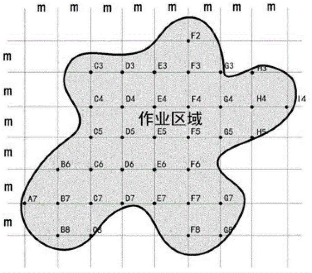
[0032] 1) Determine t...


PUM


Abstract

The invention discloses a landscape-planning-oriented image acquisition method for accurate space positioning. The method takes general packet radio service (GPRS) fixed points as the basis based on a conventional open type landscape which is difficultly and accurately positioned. The method comprises the following steps of: determining the position of an observation point through GPRS positioning; performing gridded image acquisition on the whole open location; and finally, inputting each point image and each point coordinate into a computer for linkage, so that tourists autonomously determine the sightseeing range and a sightseeing route. The quantized survey, statistics and calculation method is adopted, the method has the characteristics of high objectiveness and strictness, comprehensive display of high-quality tourism landscapes is promoted by utilizing an image acquisition technology based on global position system (GPS) accurate space positioning, convenience is provided for the tourists to autonomously select the routes, the method has good social, economical and ecological effects and provides reasonable and scientific basis for urban cruise line planning, urban tourism planning and related constructions, and precious urban tourism resources are reasonably utilized at high efficiency.

Description

technical field [0001] The invention belongs to the technical field of urban planning, and in particular relates to an image acquisition technology for precise spatial positioning oriented to urban tour route planning. Background technique [0002] The existing gps positioning technology for scenic spots that are not easy to locate with landmarks mainly uses a three-dimensional GPS positioning system, which logically consists of three parts. That is, the GPS positioning system software platform, three-dimensional Gls system, communication link, and mobile terminal software .In terms of hardware composition, the positioning system also consists of three parts, namely the ground monitoring center, communication network and mobile intelligent terminal. It is mainly used in ① scenic spot fire prevention, which is the top priority of scenic spot management. Through the construction of positioning system, the management ability of scenic spot fire prevention can be significantly i...

Claims


Application Information

Patent Timeline
Patent Type & Authority Applications(China)
IPC IPC(8): G01C21/00
Inventor 王建国杨俊宴胡昕宇
Owner SOUTHEAST UNIV
Why Eureka
Try Eureka