
Remote Sensing Image Retrieval Method Based on Multi-Feature lsh Index Combination

A remote sensing image and multi-feature technology, applied in the field of remote sensing image retrieval, can solve the problems of low time efficiency and achieve the effects of improving accuracy, fast retrieval, and solving the disaster of dimensionality

Inactive Publication Date: 2016-08-10
HOHAI UNIV
View PDF2 Cites 1 Cited by
  • Summary
  • Abstract
  • Description
  • Claims
  • Application Information

AI Technical Summary

Problems solved by technology

There are also tree algorithms based on space division, such as: R-tree, Kd-tree, SR-tree, the results returned by these algorithms are relatively accurate, but their time efficiency is not high on high-dimensional data sets

Method used


Image

  • Remote Sensing Image Retrieval Method Based on Multi-Feature lsh Index Combination
  • Remote Sensing Image Retrieval Method Based on Multi-Feature lsh Index Combination
  • Remote Sensing Image Retrieval Method Based on Multi-Feature lsh Index Combination

Examples


Embodiment Construction

[0041] The technical scheme of the present invention is described in detail below in conjunction with accompanying drawing:

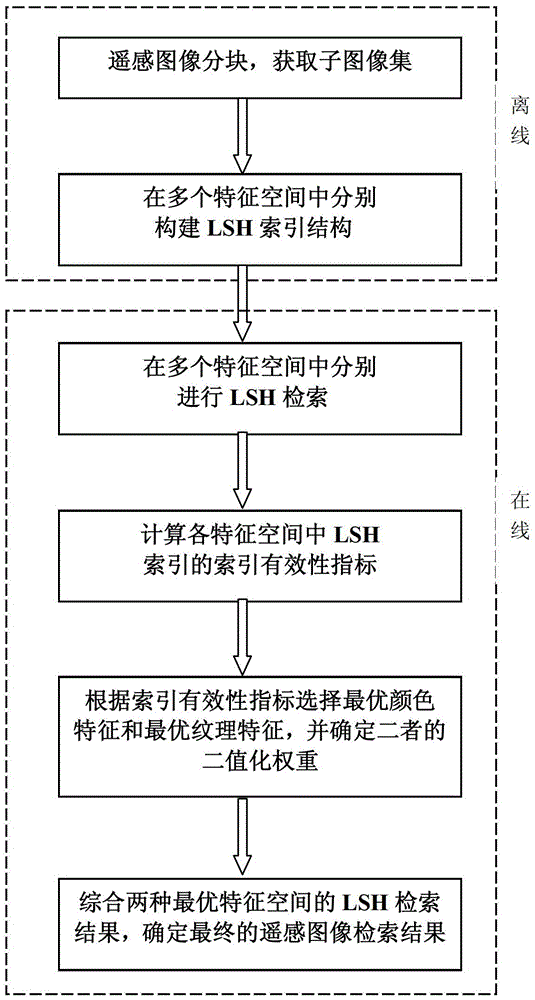
[0042] The idea of ​​the present invention is to introduce LSH index technology into the automatic query and retrieval of massive remote sensing image data, and use LSH index to solve the problem of dimension disaster and time-consuming retrieval in remote sensing image retrieval, so as to realize the rapid retrieval of remote sensing images; and for LSH The index proposes a new index validity index—feature discriminativeness-based indexing validation index (FDIVI), which can best distinguish the target from the background by evaluating the LSH index on each feature space. features, thereby effectively improving the accuracy of the retrieval results.

[0043] In order to facilitate the public to understand the technical solution of the present invention, the LSH indexing technology is briefly introduced below.

[0044] In 1998, Indyk and Motwani [Indyk...


PUM


Abstract

The invention discloses a multi-feature locality sensitive hashing (LSH) indexing combination-based remote sensing image retrieval method and belongs to the technical field of remote sensing image retrieval. According to the multi-feature LSH indexing combination-based remote sensing image retrieval method disclosed by the invention, LSH indexing of one of the best indexing technologies in high-dimensional feature spaces is introduced into the field of the remote sensing image retrieval, so that the problems of curse of dimensionality and retrieval time consuming can be effectively solved on a large scale, and the rapid retrieval of remote sensing images is realized. Meanwhile, the invention provides a new indexing validation index-a feature discriminative-ness-based indexing validation index (FDIVI) by aiming at the LSH indexing, and features best capable of distinguishing targets and backgrounds are evaluated and selected by the LSH indexing in all feature spaces, and therefore, the accuracy of a retrieval result is effectively improved. Compared with the prior art, the multi-feature LSH indexing combination-based remote sensing image retrieval method disclosed by the invention is capable of more rapidly and accurately realizing the retrieval of a great amount of remote sensing image data.

Description

technical field [0001] The invention relates to the technical field of remote sensing image retrieval, in particular to a remote sensing image retrieval method based on multi-feature LSH index combination. Background technique [0002] In the past 40 years, the amount of earth observation data has increased dramatically with the development of remote sensing technology, and various information systems have higher and higher requirements for ground object recognition technology. How to quickly and effectively classify and retrieve remote sensing images automatically has become one of the urgent problems to be solved. [0003] In general image retrieval, the retrieval target is an image or contained in an image, and the retrieval scope is other independent images in the image database. Different from general natural image retrieval, remote sensing image retrieval has the following characteristics: the target to be retrieved is in a relatively large remote sensing image, and o...

Claims


Application Information

Patent Timeline
Patent Type & Authority Patents(China)
IPC IPC(8): G06F17/30G06K9/46
Inventor 李士进谢萍冯钧於慧万定生朱跃龙
Owner HOHAI UNIV
Learn More