Method for arranging aeromagnetic survey flight paths of unmanned airship

A technology of flight route and aeromagnetic survey, applied in position/direction control, vehicle position/route/altitude control, non-electric variable control, etc., can solve the problems of complex and professional route design, and reduce the dependence on people , reduce the requirements for professional knowledge, and ensure the effect of flight safety

Active Publication Date: 2014-01-29
GEOPHYSICOCHEM ORE PROSPECTING TEAM JIANGSU GEOLOGY & MINERALS BUREAU
View PDF6 Cites 5 Cited by
  • Summary
  • Abstract
  • Description
  • Claims
  • Application Information

AI Technical Summary

Problems solved by technology

However, for many non-professionals, traditional route design is too complicated and professional

Method used


Image

  • Method for arranging aeromagnetic survey flight paths of unmanned airship
  • Method for arranging aeromagnetic survey flight paths of unmanned airship
  • Method for arranging aeromagnetic survey flight paths of unmanned airship

Examples


Embodiment

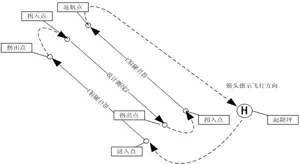
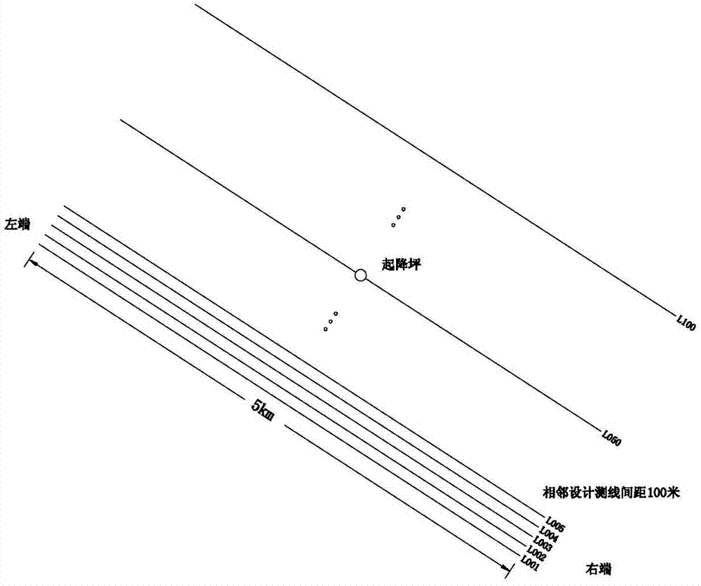
[0023] like image 3 As shown, suppose there are 100 designed measuring lines, all designed measuring lines are NW-oriented, and the length of a single designed measuring line is D i Both are 5 kilometers, the spacing h between adjacent design measuring lines is 100 meters, the design measuring line numbers are: L001, L002, ..., L050, ..., L099, L100, and the maximum flight range of the airship is D max is 100 kilometers. According to the maximum range D max and a single line length D i , it is calculated that a single design route contains no more than 20 design survey lines.

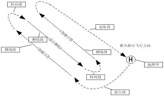
[0024] Create a new design route named FLY001, assuming that the take-off and landing pad is set in the middle of the No. is the return point; calculate the current total voyage D t =D 1 +D 2 +D 3 +D 4 , where D 1 D is the distance from the landing pad to the leftmost end of L001, calculated according to the isosceles triangle 1 =7.00km, D 2 is the sum of the lengths of all turning segments...


PUM


Abstract

The invention discloses a method for arranging aeromagnetic survey flight paths of an unmanned airship. The method includes steps of (a), acquiring design survey line data and take-off and landing platform coordinates, selecting an initial design survey line and determining an entry point and a return point; (b), computing a total range D<t> according to an equation of D<t>=D<1>+D<2>+D<3>+D<4>; (c), selecting a next design survey line and adding the next design survey line into a flight path when the D<t> is smaller than a maximum range D<max>, and computing a new D<t>; (d), repeatedly carrying out the step (c) until the new D<t> is larger than the D<max>, reducing the length of the last added design survey line by delta d until the D<t> is smaller than or equal to the D<max>, completely generating the first flight path and storing the first flight path; (e), circularly repeatedly carrying out procedures from the step (b) to the step (d) on the basis of the first flight path until all design survey lines are used, and completely arranging all the flight paths. The method has the advantages that the flight paths are divided according to attributes, and the range is limited according to the attributes, so that the flight paths can be optimized, and the requirement on professional knowledge of operators can be lowered; the method is speedy, simple and convenient and is widely applicable to designing flight paths on flat areas and flight paths on complicated mountainous and offshore terrains and the like.

Description

technical field [0001] The invention relates to the field of route planning for unmanned aerial vehicles, in particular to a fast and convenient method for arranging flight routes of unmanned airships in aeromagnetic surveying. Background technique [0002] With the increasing application of unmanned aerial vehicles, as an important factor for risk avoidance and efficiency improvement - the design of flight routes has become a key step in the implementation of measurement, which affects the efficiency, correctness and safety of measurement work. However, for many non-professionals, the traditional route design is too complicated and professional. Contents of the invention [0003] The purpose of the present invention is to provide a fast and convenient method for aeromagnetic flight route layout of unmanned airships for the defects of the traditional manual method of designing flight routes. [0004] The purpose of the present invention is solved by the following technica...

Claims


Application Information

Patent Timeline
Patent Type & Authority Applications(China)
IPC IPC(8): G05D1/00
Inventor 王波石剑龙孙希莹赵国凤季岩梁森
Owner GEOPHYSICOCHEM ORE PROSPECTING TEAM JIANGSU GEOLOGY & MINERALS BUREAU
Why Eureka
Try Eureka