Method for generating road network vector map utilizing GPS data of floating vehicles in city

A GPS data and vector map technology, applied in traffic flow detection and other directions, can solve problems such as restricting large-scale applications, high cost of road vector map production, and inconsistency with real conditions.

Active Publication Date: 2014-03-05
重庆科知源科技有限公司
View PDF5 Cites 38 Cited by
  • Summary
  • Abstract
  • Description
  • Claims
  • Application Information

AI Technical Summary

Problems solved by technology

[0005] ①The cost of road vector map production is high, which limits its large-scale application
[0007] ②Manufacturing is mostly done by hand, and the update speed is slow, resulting in poor accuracy of road vector maps
However, on the one hand, commercial road vector maps mostly rely on manual completion, and the professional quality of cartographers will have a great impact on the accuracy of the map; on the other hand, due to financial constraints, road vector maps cannot be updated in time. After that, the original road network cannot reflect the real road network
These two reasons make the road vector maps in some commercial maps have problems such as large position errors, serious road position shifts, and road network structures that do not match the real situation.

Method used


Image

  • Method for generating road network vector map utilizing GPS data of floating vehicles in city
  • Method for generating road network vector map utilizing GPS data of floating vehicles in city
  • Method for generating road network vector map utilizing GPS data of floating vehicles in city

Examples


specific Embodiment approach

[0058] The present invention will be described in detail below in conjunction with the accompanying drawings.

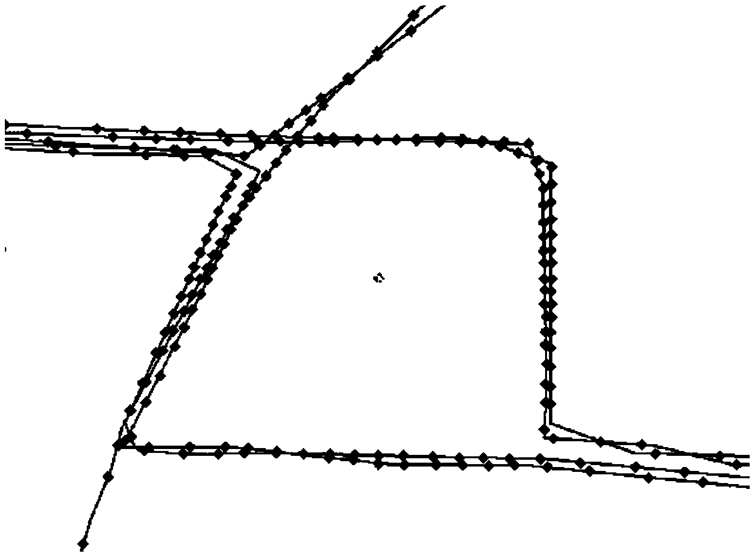
[0059] see Figure 6 A method for generating a road network vector map using GPS data of urban floating vehicles, comprising the steps of:

[0060] 1) Select the area where the road network vector map needs to be generated, filter out the GPS data of floating vehicles in the area, and group the GPS positioning points in the area according to the route; the step 1) specifically includes the following steps:

[0061] 11) Select the area where the road network vector map needs to be generated, and filter out the GPS data of floating vehicles in the area to form the vehicle trajectory;

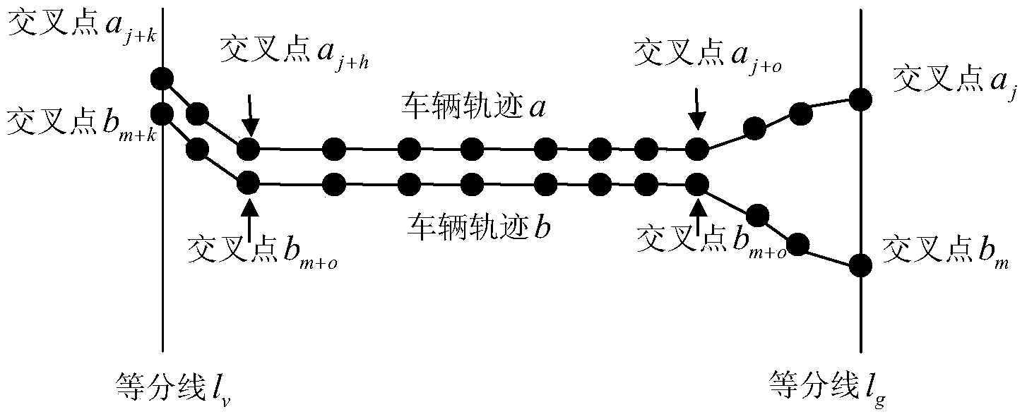
[0062] 12) Determine the coordinates of the center point of the area where the road network vector map needs to be generated, start from the center point of the area, draw an equal line, divide the area where the road network vector map needs to be generated into n equal parts, n>1, and...


PUM


Abstract

The invention relates to the field of traffic information and geographic information systems, provides a method for generating a road network vector map utilizing GPS data of floating vehicles in a city, and a high precision road vector map can be generated through the method. The method includes following steps of (1) selecting an area needed to be generated into a road network vector map, screening GPS data of floating vehicles in the area, and grouping GPS positioning points in the area according a route; (2) segmenting the grouped GPS positioning points, determining GPS data sets in each segment; (3) determining the position of a terminal point of each road by taking the GPS data sets as base data; (4) connecting each road to form a route; and (5) determining connectivity among routes, rejecting disconnected routes, generating a complete road network to obtain the road network vector map.

Description

technical field [0001] The invention relates to the fields of traffic information and geographic information systems, in particular to a method for generating a road network vector map by utilizing GPS data of urban floating vehicles. Background technique [0002] GIS (Geographic Information System, GIS) has been widely used in ITS because of its remarkable geographic graphics and spatial positioning functions, the most prominent applications are in vehicle navigation and guidance systems. The vehicle navigation and guidance system can plan and guide the vehicle's driving route reasonably based on the real-time traffic operation status, using advanced information technology and network communication technology, and can also provide users with real-time and comprehensive service information to avoid Increasing traffic congestion, improving the safety and efficiency of transportation. Vehicle navigation and guidance system has become an important part of ITS. [0003] Vector...

Claims


Application Information

Patent Timeline
Patent Type & Authority Applications(China)
IPC IPC(8): G08G1/01
Inventor 孙棣华刘卫宁廖孝勇赵敏郑林江徐静
Owner 重庆科知源科技有限公司
Why Eureka
Try Eureka