
A method and system for estimating the geographic location of a base station

A technology of geographic location and base station, applied in the field of communication, can solve the problem of affecting the base station, the geographic location of the base station without actual geographic location information, affecting the asset management and maintenance of the base station, etc., to achieve the effect of improving the accuracy

Active Publication Date: 2017-01-11
CHINA UNITED NETWORK COMM GRP CO LTD
View PDF3 Cites 0 Cited by
  • Summary
  • Abstract
  • Description
  • Claims
  • Application Information

AI Technical Summary

Problems solved by technology

[0003] Due to the long period of manual maintenance of the geographic location of the base station, the timeliness of input is very low, and the geographic location of many base stations has no actual geographic location information for a long time, or the geographic location information is outdated, which affects the asset management and maintenance of the base station and affects the accuracy of the location of the base station. , affecting other services of operators based on the geographical location information of base stations

Method used


Image

  • A method and system for estimating the geographic location of a base station
  • A method and system for estimating the geographic location of a base station
  • A method and system for estimating the geographic location of a base station

Examples


Embodiment 1

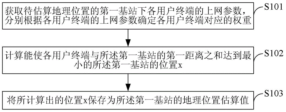
[0034] Embodiment 1. A method for estimating the geographic location of a base station, such as figure 1 shown, including:

[0035] S101. Obtain the Internet access parameters of each user terminal under the first base station whose geographic location is to be estimated, and determine the corresponding weights of each user terminal according to the Internet access parameters of each user terminal;

[0036] S102. Calculate the position x of the first base station that minimizes the sum of the first distances between each user terminal and the first base station; the first distance between the user terminal and the first base station is the user terminal multiplying the position distance from the first base station by the weight corresponding to the user terminal;

[0037] S103. Save the calculated position x as an estimated geographic position value of the first base station.

[0038] In this embodiment, the first distance of user terminal i can be regarded as the behavior t...

Embodiment 2

[0058] Embodiment 2. A system for estimating the geographic location of a base station, such as image 3 shown, including:

[0059] The extraction unit 31 is configured to obtain the Internet access parameters of each user terminal under the first base station whose geographic location is to be estimated, and determine the corresponding weight of each user terminal according to the Internet access parameters of each user terminal;

[0060] A calculation unit 32, configured to calculate a position x of the first base station that minimizes the sum of first distances between each user terminal and the first base station; the first distance between the user terminal and the first base station is the The position distance of the user terminal is multiplied by the corresponding weight of the user terminal;

[0061] The storage unit 33 is configured to store the calculated position x as an estimated geographic position value of the first base station.

[0062] In an implementation...


PUM


Abstract

The invention provides an estimation method and system for the geographic position of a base station. The method includes the steps that internet access parameters of all user terminals of a first base station with the geographic position to be estimated are obtained, and corresponding weights of all the user terminals are determined according to the internet access parameters of all the user terminals respectively; the position x, which enables the sum of first distances between all the user terminals and the first base station to reach minimum, of the first base station is calculated; the position distances of the user terminals are multiplied by the corresponding weights to serve as the first distances between the user terminals and the first base station; the calculated position x is stored as an estimation value of the address position of the first base station. The estimation method and system can estimate the geographic position of the base station.

Description

technical field [0001] The present invention relates to the communication field, in particular to a method and system for estimating the geographic location of a base station. Background technique [0002] The geographical location of the base station is an important asset of the operator. It is not only important data for the operator to manage and maintain base station assets, but also the basic data for the operator to provide base station positioning services. With the rapid development of the mobile Internet, operators are speeding up the construction of base stations. Every year, many new base stations are used on the network. Since the geographical location of the base station construction may not be consistent with the planned geographical location, it is necessary to manually search and enter the actual location of the base station in the later stage. Construction of geographical location; In addition, due to frequent changes of mobile network equipment, the corresp...

Claims


Application Information

Patent Timeline
Patent Type & Authority Patents(China)
IPC IPC(8): H04W24/04H04W64/00
Inventor 肖吉李希金
Owner CHINA UNITED NETWORK COMM GRP CO LTD
Learn More