Extra-large remote sensing image display method based on pyramids and image rendering engine

A technology of remote sensing images and pyramids, applied in still image data indexing, program control devices, electrical digital data processing, etc., can solve the problems of data format, image resolution, projection mode inconsistency, transparent color, and layer display order display effect , remote sensing image visualization methods are not open, etc., to achieve the effect of reducing the number of visits, reducing time, and reducing reading pressure

Active Publication Date: 2014-03-26
SPACE STAR TECH CO LTD
View PDF2 Cites 8 Cited by
  • Summary
  • Abstract
  • Description
  • Claims
  • Application Information

AI Technical Summary

Problems solved by technology

This brings several problems to the area-oriented remote sensing image data display: 1. The data volume is large, and the single-scene image data of many satellites reaches more than 2G, and the overall data volume of the area-oriented remote sensing image is quite large; 2. Data format , image resolution, and projection methods are inconsistent; 3. Transparent color and layer display order have an impact on the display effect
However, as a commercial software, its corresponding remote sensing image visualization method is not public, and can only be used by using the software or its corresponding secondary development kit

Method used


Image

  • Extra-large remote sensing image display method based on pyramids and image rendering engine
  • Extra-large remote sensing image display method based on pyramids and image rendering engine
  • Extra-large remote sensing image display method based on pyramids and image rendering engine

Examples


Embodiment Construction

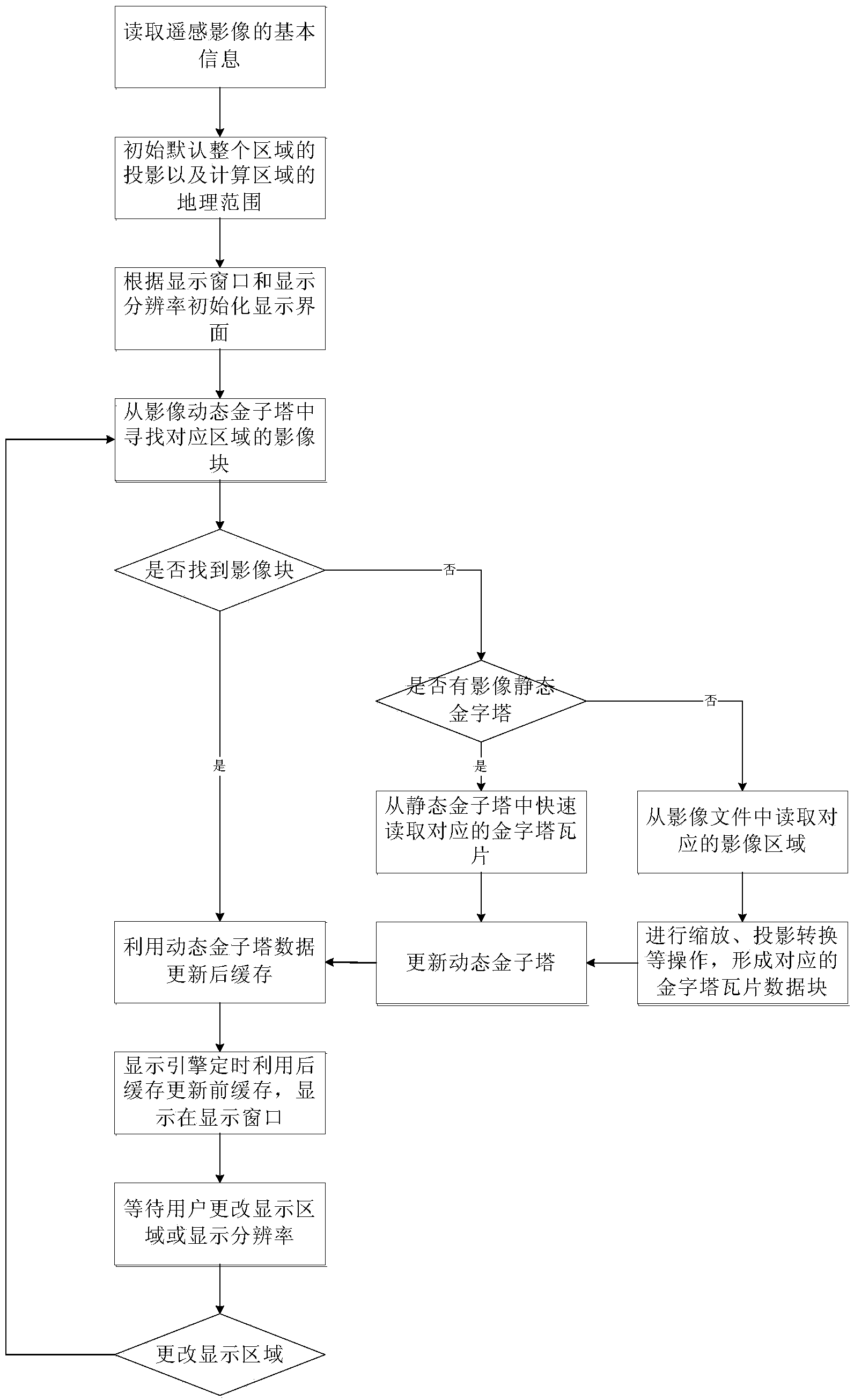
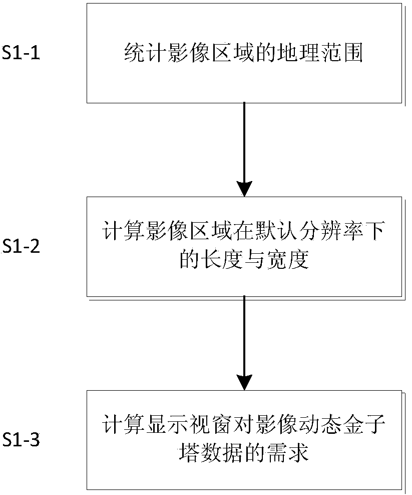
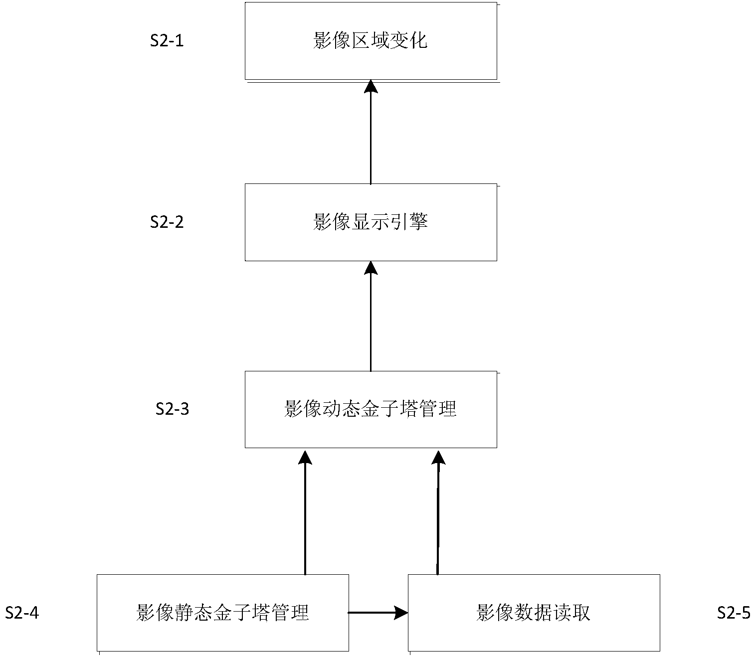
[0022] The method of the invention adopts pyramid and rendering engine technology to jointly realize the visualization of large-area remote sensing images. Among them, pyramids are divided into static pyramids and dynamic pyramids. The static pyramid is an image block index file stored locally, which stores the geographic location, resolution, usage frequency, and existence status information of the overall image and image blocks. The dynamic pyramid is a memory pool with a fixed size, which realizes the management of image blocks in memory, and saves the geographic location, image block size, usage frequency, and resolution information of image blocks.

[0023] Pyramid management uses the geographic location of the display window as input, and uses dynamic pyramids as the first data source to directly provide image data to be drawn for the display engine, and uses static pyramids as the second data source to directly recover dynamic pyramids from static pyramid blocks block,...


PUM


Abstract

The invention discloses an extra-large remote sensing image display method based on pyramids and an image rendering engine. Dynamic management on image display is achieved through a pyramid data structure, the geographic position of a display window is used as an input, the dynamic pyramid is used as a first data source which directly provides image data to be rendered for a display engine, the static pyramid is used as a second data source, dynamic pyramid blocks are directly recovered from static pyramid blocks, image files are used as a third data source, image data are read from the corresponding area of the corresponding file according to the requirements of the dynamic pyramid blocks, and conversion is conducted according to display requirements. According to the extra-large remote sensing image display method based on the pyramids and the image rendering engine, the dynamic pyramid and the static pyramid work synergistically, so that time consumption for a large amount of memory IO in the extra-large remote sensing image display process is avoided, and the rapid display is achieved. In addition, display parameters of specific areas are stored, complete image data are stored through static pyramid files, and image fast display based on specific areas in later period is supported.

Description

technical field [0001] The invention relates to a processing method for remote sensing images. Background technique [0002] With the continuous development of earth observation technology, the resolution of satellite earth observation has been continuously improved, and the data volume of satellite images has increased dramatically. On the other hand, due to the influence of the orbital parameters of the satellite itself when using satellites to obtain ground images, it is difficult for a single-view satellite image to cover the entire region of interest, and multi-view image data is required to obtain the overall situation of the region of interest. In special cases, when the image data of one satellite cannot cover the entire area of ​​interest, it is necessary to combine other satellite data or aerial data. This brings several problems to the area-oriented remote sensing image data display: 1. The data volume is large. Many satellite single-view image data reach more th...

Claims


Application Information

Patent Timeline
Patent Type & Authority Applications(China)
IPC IPC(8): G06F17/30G06F9/44
CPCG06F16/29G06F16/51
Inventor 童俊涛李申阳邹同元
Owner SPACE STAR TECH CO LTD
Why Eureka
Try Eureka