Supercharge Your Innovation With Domain-Expert AI Agents!

An Alternative Method for Quick View of Remote Sensing Satellite Data

A technology for remote sensing satellites and data, which is applied in the field of remote sensing satellite data processing to achieve the effect of ensuring normal operation, intuitive and accurate display

Active Publication Date: 2017-05-10
CENT FOR EARTH OBSERVATION & DIGITAL EARTH CHINESE ACADEMY OF SCI
View PDF3 Cites 0 Cited by
  • Summary
  • Abstract
  • Description
  • Claims
  • Application Information

AI Technical Summary

Problems solved by technology

[0005] The purpose of the present invention is to provide an alternative method for fast viewing of remote sensing satellite data, which does not rely on decompression equipment, and solves the problem of intuitive, qualitative and qualitative display of satellite raw data quality

Method used


Image

  • An Alternative Method for Quick View of Remote Sensing Satellite Data
  • An Alternative Method for Quick View of Remote Sensing Satellite Data
  • An Alternative Method for Quick View of Remote Sensing Satellite Data

Examples


Embodiment Construction

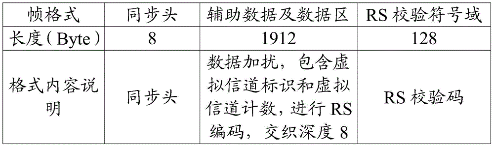
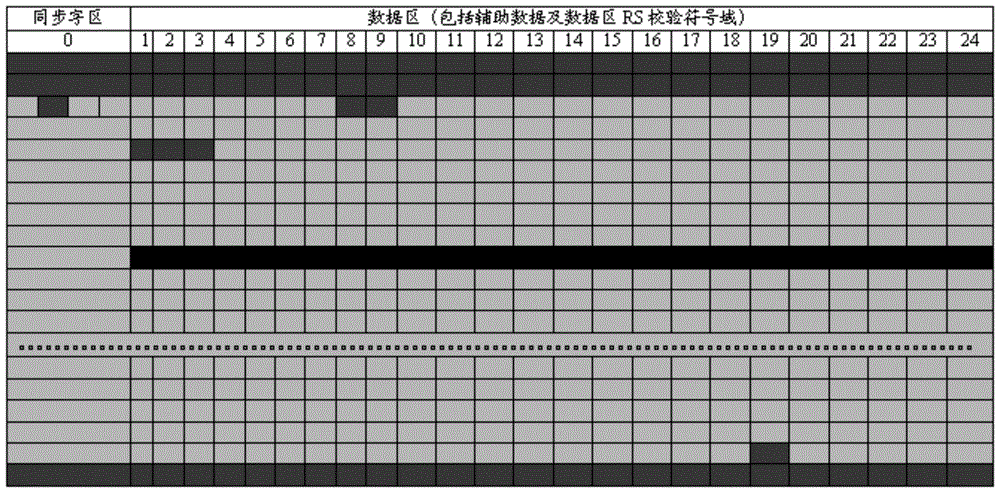
[0021] In order to make the purpose, technical solution and advantages of the present invention clearer, the present invention will be further described in detail below in conjunction with the embodiments and accompanying drawings. This embodiment takes the original data format of a certain satellite as an example to describe the quick-view display method in detail.

[0022] The remote sensing satellite data quick view alternative method described in the embodiment of the present invention comprises the following steps:

[0023] 1) Different colors are set for different bit error situations. The data with a bit error rate of 1 is represented in red, the data with a bit error rate of 0 is represented in green, and the data with an uncertain bit error rate is represented in gray. The data with a bit error rate between 1E-16 and 1 is represented by the transition color between yellow and red. In order to distinguish different bit error situations by color, the transition is calcul...


PUM


Abstract

The invention relates to a remote-sensing satellite data quick-look substitution method. According to known information including frame synchronization word, RS coding and virtual channel counter and the like of original data, error code situations are determined; and error code situations are expressed by different colors. According to the invention, a remote-sensing satellite original data visual data quality visual-displaying method is provided and can replace the traditional remote-sensing image display quick-look method. The provided method has the following beneficial effects: the method is independent of a remote-sensing satellite data quick-look unit of decompression equipment; the receiving data quality is display visually and accurately; and the normal operation of the receiving system is guaranteed.

Description

technical field [0001] The invention relates to the field of remote sensing satellite data processing, in particular to a remote sensing satellite data quick view replacement method. Background technique [0002] The function of remote sensing satellite data quick view is to qualitatively judge the quality of satellite data reception by displaying the received images in real time during the satellite reception process, which plays an important role in ensuring the normal operation of the reception system. [0003] Most of the remote sensing satellites currently in orbit and to be launched in the future compress the image data on the satellite, and the ground receiving system needs to decompress the image data for quick-view display. At present, the satellite research and development unit does not disclose the satellite data compression format. To realize the decompression function, it must purchase its exclusive monopoly decompression equipment. The cost of deploying the qu...

Claims


Application Information

Patent Timeline
Patent Type & Authority Patents(China)
IPC IPC(8): H04L1/00G06F17/30H04N7/20G01S13/89G01S7/02
Inventor 李景山
Owner CENT FOR EARTH OBSERVATION & DIGITAL EARTH CHINESE ACADEMY OF SCI
Features
  • R&D
  • Intellectual Property
  • Life Sciences
  • Materials
  • Tech Scout
  • Unparalleled Data Quality
  • Higher Quality Content
  • 60% Fewer Hallucinations
Learn More