A combined vehicle navigation system based on mems inertial navigation

A vehicle-mounted navigation and inertial navigation module technology, applied in the field of navigation, can solve the problems of low accuracy and low reliability of navigation and positioning information

Active Publication Date: 2016-05-18
BEIJING RONGZHILIDA TECH
View PDF6 Cites 0 Cited by
  • Summary
  • Abstract
  • Description
  • Claims
  • Application Information

AI Technical Summary

Problems solved by technology

[0005] In order to solve the problem of low accuracy and low reliability of the output navigation positioning information when the satellite signal is out of lock in the existing vehicle navigator, the present invention provides a combined vehicle navigation system based on MEMS inertial navigation

Method used


Image

  • A combined vehicle navigation system based on mems inertial navigation
  • A combined vehicle navigation system based on mems inertial navigation
  • A combined vehicle navigation system based on mems inertial navigation

Examples


Embodiment Construction

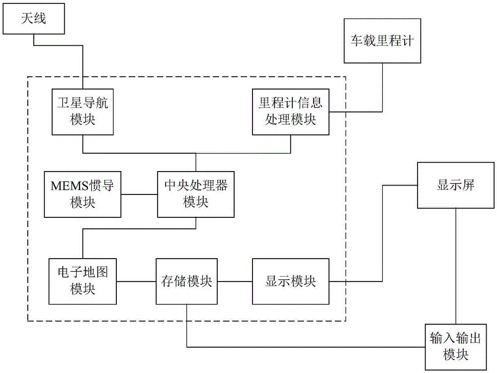
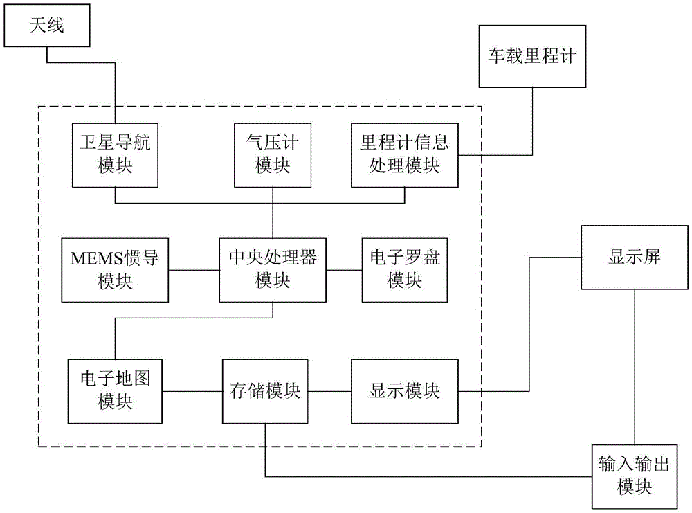
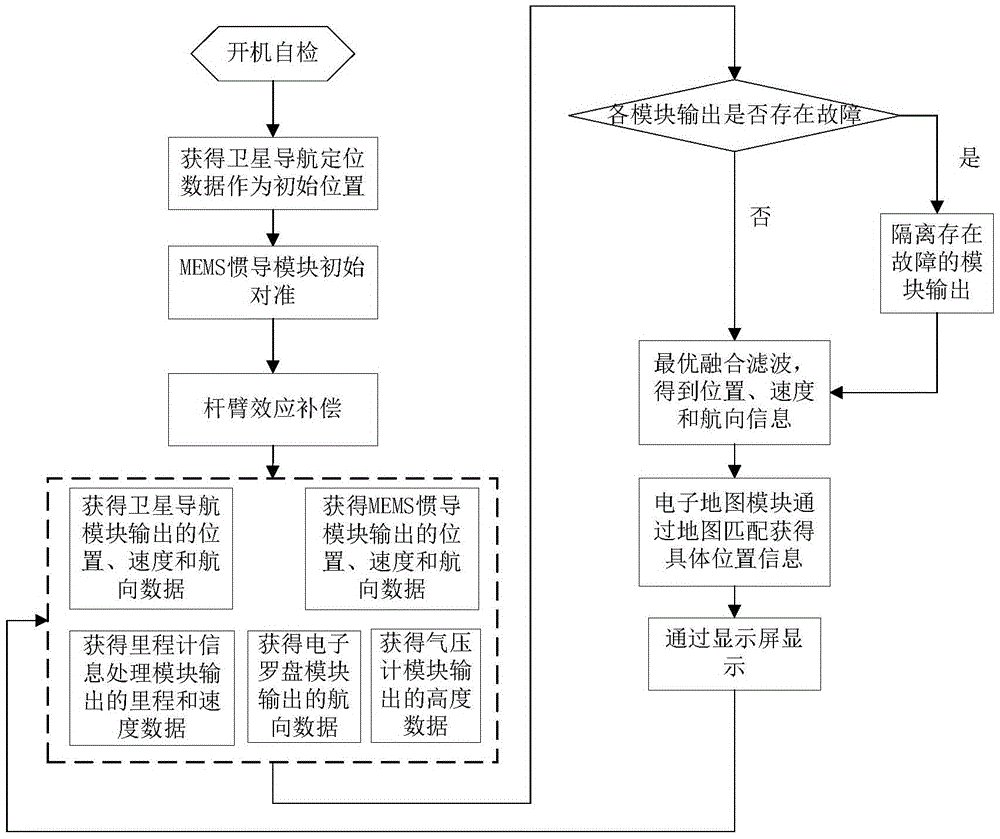
[0036] Before explaining the technical solution of the present invention, some words in the description process are first explained:

[0037] The data output by each module in the vehicle-mounted navigation system of the present invention, such as speed, position, heading, pitch angle, etc., all refer to the driving parameters of the vehicle that loads the vehicle-mounted navigation system. However, due to different factors such as the accuracy of each module, the value of the data with the same name at the same time will be different.

[0038] Satellite navigation module: a hardware module that exchanges information with space positioning satellites to determine the current location, such as a navigation module based on GPS, GLONASS, Galileo and Beidou satellites. Mature products such as the UBX-G6010-ST satellite navigation module produced by Swiss u-blox company.

[0039] MEMS inertial navigation module: MEMS is the abbreviation of Micro-Electro-MechanicalSystem, MEMS iner...


PUM


Abstract

The invention provides a combined vehicle navigation system based on MEMS inertial navigation, which includes a satellite navigation module and a MEMS inertial navigation module; it also includes an odometer information processing module, an electronic map module, a storage module, a display module and a central processing unit module; The satellite navigation module, the MEMS inertial navigation module, and the odometer information processing module are respectively connected to the central processor module; the electronic map module is respectively connected to the central processor module and the storage module, and the The storage module is connected to the display module. The vehicle navigation system of the present invention can still output accurate navigation information when the satellite signal is out of lock, and has high precision and reliability.

Description

technical field [0001] The invention relates to the technical field of navigation, in particular to a vehicle navigation system. Background technique [0002] At present, most vehicles are equipped with car navigators. These navigators mainly use the satellite positioning module to determine the position, and the obtained position information is matched with the electronic map module to perform position display, route planning and navigation on the electronic map. This navigator mainly relies on satellites for positioning, such as GPS, GLONASS, Galileo and Beidou. However, a major problem with this kind of navigator is that when the vehicle is driving in the city, the satellite signal will often lose lock when it is adjacent to tall buildings or woods, or when passing through a tunnel. The essence is that the satellite signal is blocked by the above-mentioned obstacles. This type of navigator cannot work normally. [0003] In order to solve the above-mentioned problems of ...

Claims


Application Information

Patent Timeline
Patent Type & Authority Patents(China)
IPC IPC(8): G01C23/00
CPCG01C21/165G01C23/00G01S19/49G01C21/30
Inventor 王博李冰
Owner BEIJING RONGZHILIDA TECH
Why Eureka
Try Eureka