Automatic composition and integration method for multi-source vector geographic information data

A technology of information data and vector geography, applied in the field of mapping of multi-source vector GIS data, can solve the problem of data duplication and achieve the effect of avoiding duplication of data

Inactive Publication Date: 2014-08-06
CHONGQING UNIV
View PDF3 Cites 30 Cited by
  • Summary
  • Abstract
  • Description
  • Claims
  • Application Information

AI Technical Summary

Problems solved by technology

[0007] The purpose of the present invention is to provide a method for automatic composition and integration of multi-source vector geographic information data. It integrates multi-source GIS data and also adopts an integrated strategy for the GIS data mapping process, which solves the problem of GIS data in traditional cartography. The problem of separation of application and map drawing avoids the problem of data duplication in traditional drawing methods

Method used


Image

  • Automatic composition and integration method for multi-source vector geographic information data
  • Automatic composition and integration method for multi-source vector geographic information data
  • Automatic composition and integration method for multi-source vector geographic information data

Examples


Embodiment Construction

[0052] The present invention will be further described below in conjunction with drawings and embodiments.

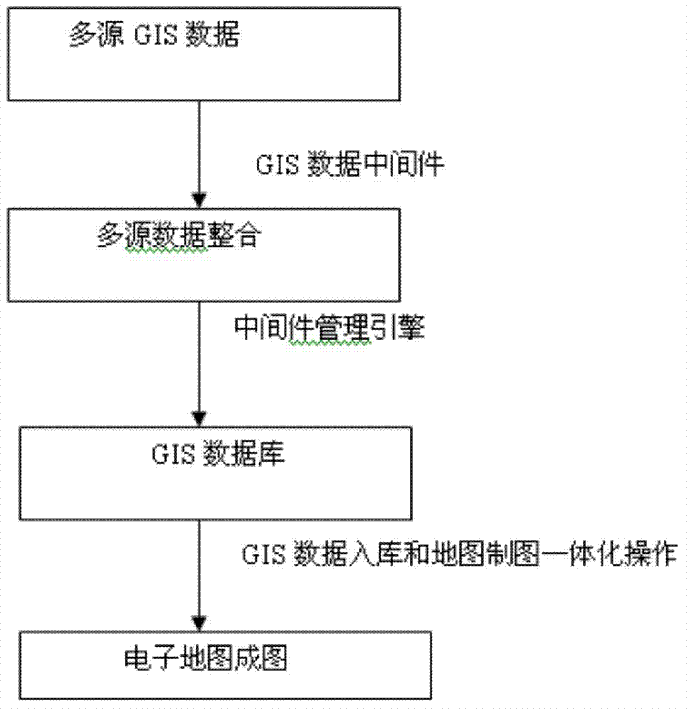
[0053] The main steps of the present invention include two steps: the integration of multi-source GIS data, the integration of GIS data storage and map drawing. Each part of the process is as follows:

[0054] 1. Integration of multi-source GIS data

[0055] In this step, the GIS data middleware pattern is used to realize the integration of multi-source GIS data. The realization of the data middleware mode is divided into three parts: the realization of the data middleware generation environment, the realization of the kernel data interface, and the realization of the middleware management engine. Each data source in a different format corresponds to a corresponding middleware. For example, the MapInfo data source is interpreted by the MapInfo data middleware. After the middleware corresponding to each format of data is implemented, compile and link it to form a DLL ...


PUM


Abstract

Provided is an automatic composition and integration method for multi-source vector geographic information data. The traditional technology is improved from two aspects that (1) for the fusion of multi-source GIS data, a GIS data middleware technology is adopted, respective tasks of a developer and a data provider are distinct, due to the fact that data middleware interfaces are arranged, spatial data provided by GIS systems in different types are received by different pieces of data middleware and are converted into one piece in standard GIS data, the multi-source spatial data can be loaded fast in parallel, and new data sources can be added subsequently through expansion; (2) for the charting process of the GIS data, the strategy of integrating the GIS data and map making is adopted in the method, the problem of the separation of the GIS application and the map making in the traditional charting mode is solved, and the phenomena of repetitive production of data and the like in the traditional charting mode are avoided.

Description

technical field [0001] The invention relates to the technical field of computer digital drawing, in particular to a drawing method of multi-source vector GIS data. Background technique [0002] Traditional map drawing is drawn directly on paper materials by hand. This drawing method is not only inefficient, but also difficult to modify and update the map. With the development of computer technology, computer drawing has gradually replaced manual drawing. Computer-aided cartography draws digital maps based on geographic information data (such as survey data or GIS data), which not only improves the production efficiency of data, but also speeds up the speed of data update, greatly shortening the cycle of map production and update. GIS data is a type of geospatial data. With the rapid development of observation technology and Geographic Information System (GIS) technology, the collection, storage, analysis, and application of spatial data and geographic information have grad...

Claims


Application Information

Patent Timeline
Patent Type & Authority Applications(China)
IPC IPC(8): G06F17/30
CPCG06F16/252G06F16/29
Inventor 张可柴毅钱锟熊英志周国庆
Owner CHONGQING UNIV
Why Eureka
Try Eureka