Automatic extraction method for newly-increased construction land image spots in high-resolution remote sensing images based on NDVI and PanTex index

A remote sensing image, high-resolution technology, applied in image analysis, image data processing, character and pattern recognition, etc., can solve problems such as missed detection or false detection

Active Publication Date: 2014-08-06
INST OF REMOTE SENSING & DIGITAL EARTH CHINESE ACADEMY OF SCI +1
View PDF4 Cites 29 Cited by
  • Summary
  • Abstract
  • Description
  • Claims
  • Application Information

AI Technical Summary

Problems solved by technology

When in use, using a single feature for change detection may cause missed or false detections. Therefore, multiple features should be used comprehensively to achieve change detection.

Method used


Image

  • Automatic extraction method for newly-increased construction land image spots in high-resolution remote sensing images based on NDVI and PanTex index
  • Automatic extraction method for newly-increased construction land image spots in high-resolution remote sensing images based on NDVI and PanTex index
  • Automatic extraction method for newly-increased construction land image spots in high-resolution remote sensing images based on NDVI and PanTex index

Examples


Embodiment Construction

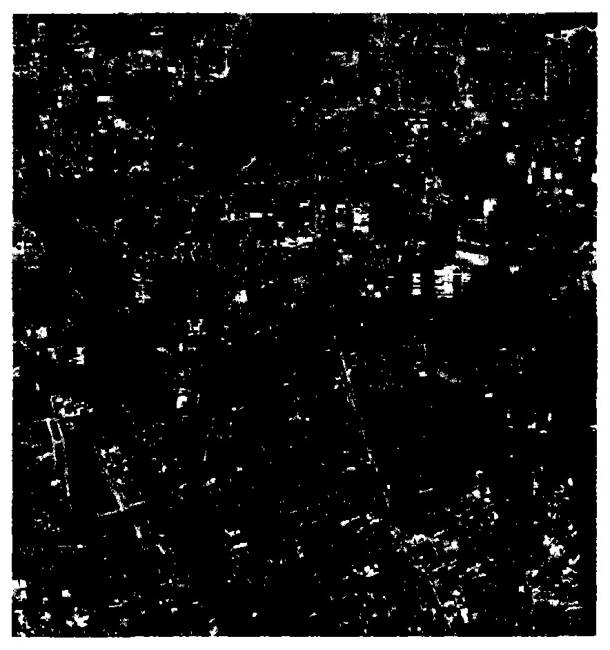
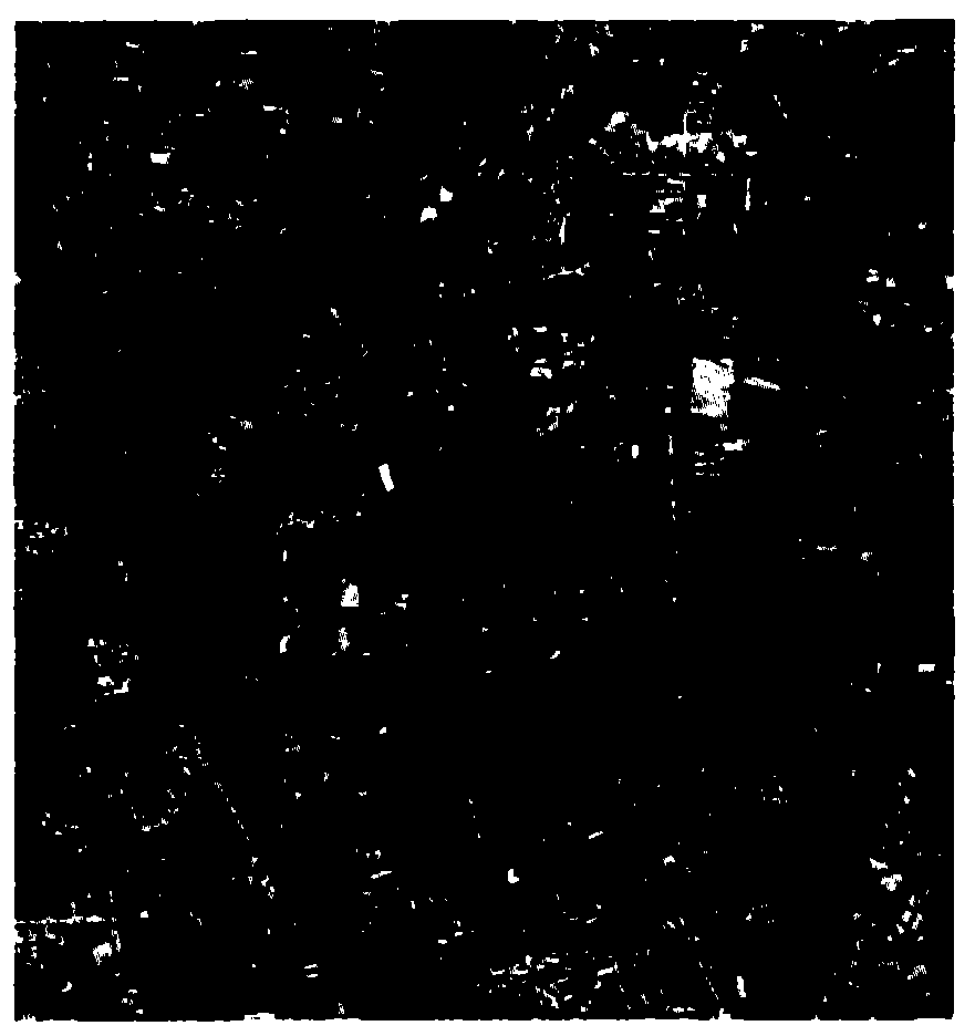
[0082] The present invention takes the ZY-1-02C image of Changping District, Beijing, as an example, to illustrate the specific implementation of the new construction map spot extraction. The shooting time of the pre-phase experimental images was October 24, 2012, and the shooting time of the post-phase experimental images was August 18, 2013. The experimental images are as follows: figure 2 , 3 shown. The present invention will be further described below in conjunction with the accompanying drawings.

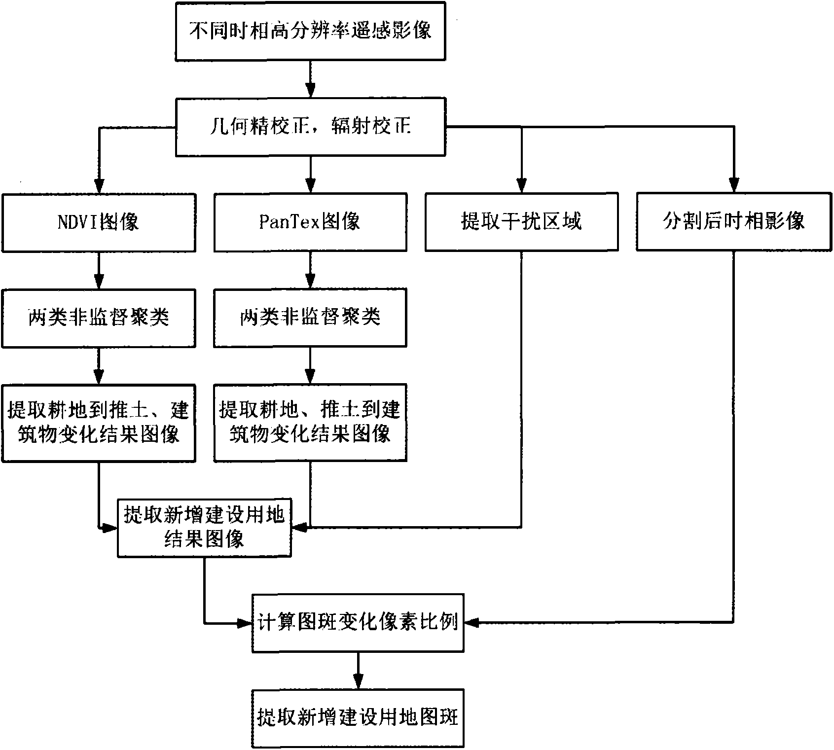
[0083] Such as figure 1 As shown, it is a flow chart of the method for automatically extracting map spots for new construction of high-resolution remote sensing images based on NDVI and PanTex index in an embodiment of the present invention. This embodiment includes the following steps:

[0084] Step 1. Perform geometric fine correction and relative radiometric correction on high-resolution remote sensing images in different time phases;

[0085] Step 2, using the multispe...


PUM


Abstract

The invention relates to an automatic extraction method for newly-increased construction land image spots in high-resolution remote sensing images based on the NDVI and the PanTex index. The method includes the first step of inputting a front time phase high-resolution remote sensing image and a back time phase high-resolution remote sensing image, and then conducting geometric fine correction and relative radiation correction, the second step of calculating a front time phase NDVI image, a back time phase NDVI image, a front time phase PanTex image and a back time phase PanTex image, the third step of conducting unsupervised clustering on the two NDVI images and the two PanTex images respectively, the fourth step of extracting a binary change image from vegetation to buildings, bulldozed and filled earth according to the two NDVI clustered images, the fifth step of extracting a binary change image from vegetation, bulldozed and filled earth to the buildings according to the two PanTex clustered images, the sixth step of extracting interfering ground object regions, the seventh step of conducting union operation on the two extracted change images and removing interfering ground object masks to obtain a newly-increased construction land image, the eighth step of segmenting the back time phase images, and the ninth step of calculating the proportion of changed pixels in each segmented image spot and extracting the newly-increased construction land image spots. Through the method, three types of newly-increased construction land image spots can be effectively extracted, and auxiliary information can be provided for land utilization change investigation.

Description

technical field [0001] The invention belongs to the technical field of remote sensing image processing, and mainly relates to a method for detecting newly added construction land in land use change detection, in particular to a method for automatically extracting map spots for newly added construction in high resolution remote sensing images based on NDVI and PanTex index. Background technique [0002] Land use / cover is a comprehensive result of the interaction between human and land. At the same time, as the most basic data needed for various resource management and geographic information services, the acquisition, analysis and update of land use / cover information is particularly important. [0003] Because of its macroscopic and real-time nature, remote sensing image data has always been the most important means of land use / cover and its change detection. High-resolution remote sensing images have become an important data source for land use / cover change information becau...

Claims


Application Information

Patent Timeline
Patent Type & Authority Applications(China)
IPC IPC(8): G06K9/46G06T7/00
Inventor 孟瑜袁媛刘顺喜尤淑撑陈静波岳安志王忠武武斌
Owner INST OF REMOTE SENSING & DIGITAL EARTH CHINESE ACADEMY OF SCI
Why Eureka
Try Eureka