Method to estimate intensity of tropical cyclone across the Northwest Pacific Ocean by using geostationary meteorological satellite image

A geostationary meteorological satellite, tropical cyclone technology, applied in the field of atmospheric scientific research, can solve the problems of cirrus cloud interference and divergence in the IRW cloud image of the geostationary meteorological satellite

Inactive Publication Date: 2014-09-10
NANJING UNIV
View PDF2 Cites 7 Cited by
  • Summary
  • Abstract
  • Description
  • Claims
  • Application Information

AI Technical Summary

Problems solved by technology

[0005] IRW cloud images of geostationary weather satellites are easily disturbed by cirrus clouds
In addition, t

Method used


Image

  • Method to estimate intensity of tropical cyclone across the Northwest Pacific Ocean by using geostationary meteorological satellite image
  • Method to estimate intensity of tropical cyclone across the Northwest Pacific Ocean by using geostationary meteorological satellite image
  • Method to estimate intensity of tropical cyclone across the Northwest Pacific Ocean by using geostationary meteorological satellite image

Examples


Embodiment Construction

[0036] The scheme of the present invention is described in detail below:

[0037] The first step is preprocessing:

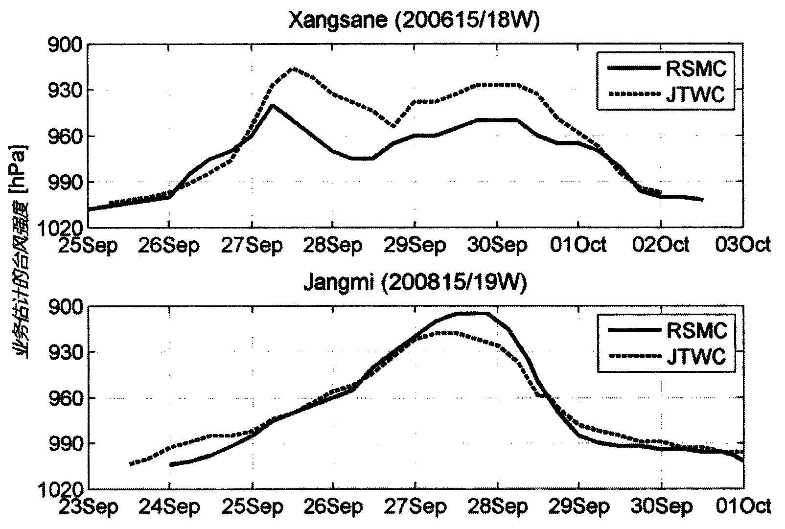
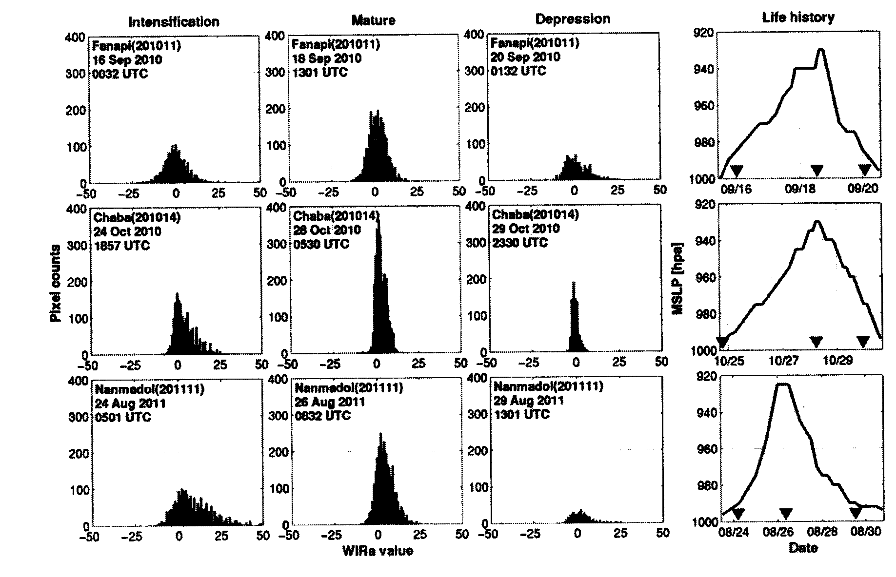
[0038] We selected all 35 strong typhoon cases from 2006 to 2011, and the detailed information is shown in Table 2:

[0039] Table 2. Names and IDs of 35 strong typhoon cases.

[0040]

[0041] The brightness temperature information of the infrared window area and the water vapor channel of the typhoon core area is extracted from the satellite cloud images of equal latitude and longitude at various times corresponding to the typhoon. The core area refers to the area within 150km from the center of the typhoon.

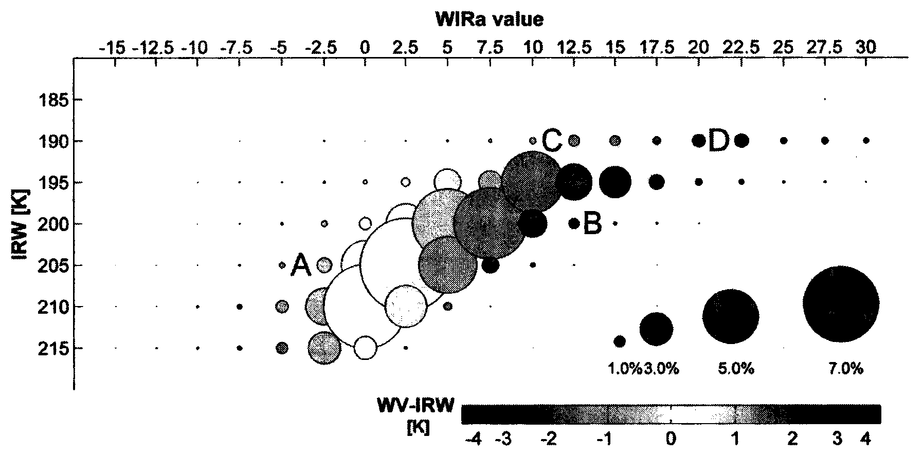
[0042] The second step is to confirm the WIRa parameters:

[0043] This parameter can distinguish common convection from cirrus, penetrating convection, and water vapor anomalies on static satellite cloud images. Its theoretical basis is as follows: As shown in Table 3, the negative Tb WV-IRW is caused by cirrus clouds and weak convection, and the...


PUM


Abstract

The invention discloses a method to estimate the intensity of tropical cyclones across the Northwest Pacific Ocean by using a geostationary meteorological satellite image. The method is characterized by comprising the following steps: extracting the information of the infrared window area brightness temperature and the water vapor channel brightness temperature of a typhoon inner core area in a satellite image in which the interval of longitude is equal to the interval of latitude ; acquiring the WIRA index values by using the brightness temperature information; calculating the mean value for total WIRA index values acquired, to acquire the mean value , and to count total corresponding pixel points W when the WIRA index values are in the range of in the typhoon core area; and using the typhoon intensity equation: I=985.474-0.033xW-2.391x10<-5>xW<2> to obtain the typhoon intensity. This method can indicate the symmetric level changes for the convective axis, and can also exclude thin cirrus, stratospheric water vapor anomalies and penetrating convection, and can provide indexes that are best related with the intensity of the optimal path of a typhoon, so that the typhoon intensity is calculated more accurately.

Description

technical field [0001] The invention relates to a method for estimating the intensity of a tropical cyclone, in particular to a method for estimating the intensity of a tropical cyclone by using static meteorological satellite images, and belongs to the field of atmospheric science research. Background technique [0002] Typhoons are the most serious natural disasters, and both coastal areas and inland areas hundreds of kilometers away from the sea may be affected by them. Real-time monitoring of the birth, development and strengthening of typhoons can ensure timely emergency response and effectively reduce local economic losses and casualties. Geostationary meteorological satellite remote sensing has high time resolution (compared to microwave remote sensing of polar-orbiting satellites, such as Velden et al. 1992; Wu et al.2005; Aberson et al.2006), the advantages of being able to cover oceans and sparsely populated areas (compared to ground-based radars such as Corbosier...

Claims


Application Information

Patent Timeline
IPC IPC(8): G06T5/00
Inventor 诸葛小勇管健郁凡王元
Owner NANJING UNIV
Why Eureka
Try Eureka