Automatic elevation transmission coordinatograph

A coordinate instrument and elevation technology, applied in the field of elevation transfer measurement devices, can solve the problems of low measurement accuracy and high labor intensity, and achieve the effects of high measurement accuracy and improved measurement accuracy.

Active Publication Date: 2014-10-29
NARI TECH CO LTD +1
View PDF7 Cites 0 Cited by
  • Summary
  • Abstract
  • Description
  • Claims
  • Application Information

AI Technical Summary

Problems solved by technology

[0007] The purpose of the present invention is to overcome the shortcomings of high labor intensity and low measurement accuracy of the steel tape ruler-type elevation transfer coordinate instrument, and to provide an automatic and high-precision elevation transfer coordinate instrument

Method used


Image

  • Automatic elevation transmission coordinatograph
  • Automatic elevation transmission coordinatograph
  • Automatic elevation transmission coordinatograph

Examples


Embodiment Construction

[0037] In order to make the object, technical solution and advantages of the present invention clearer, the present invention will be further described in detail below in conjunction with the accompanying drawings and embodiments. It should be understood that the specific embodiments described here are only used to explain the present invention, not to limit the present invention.

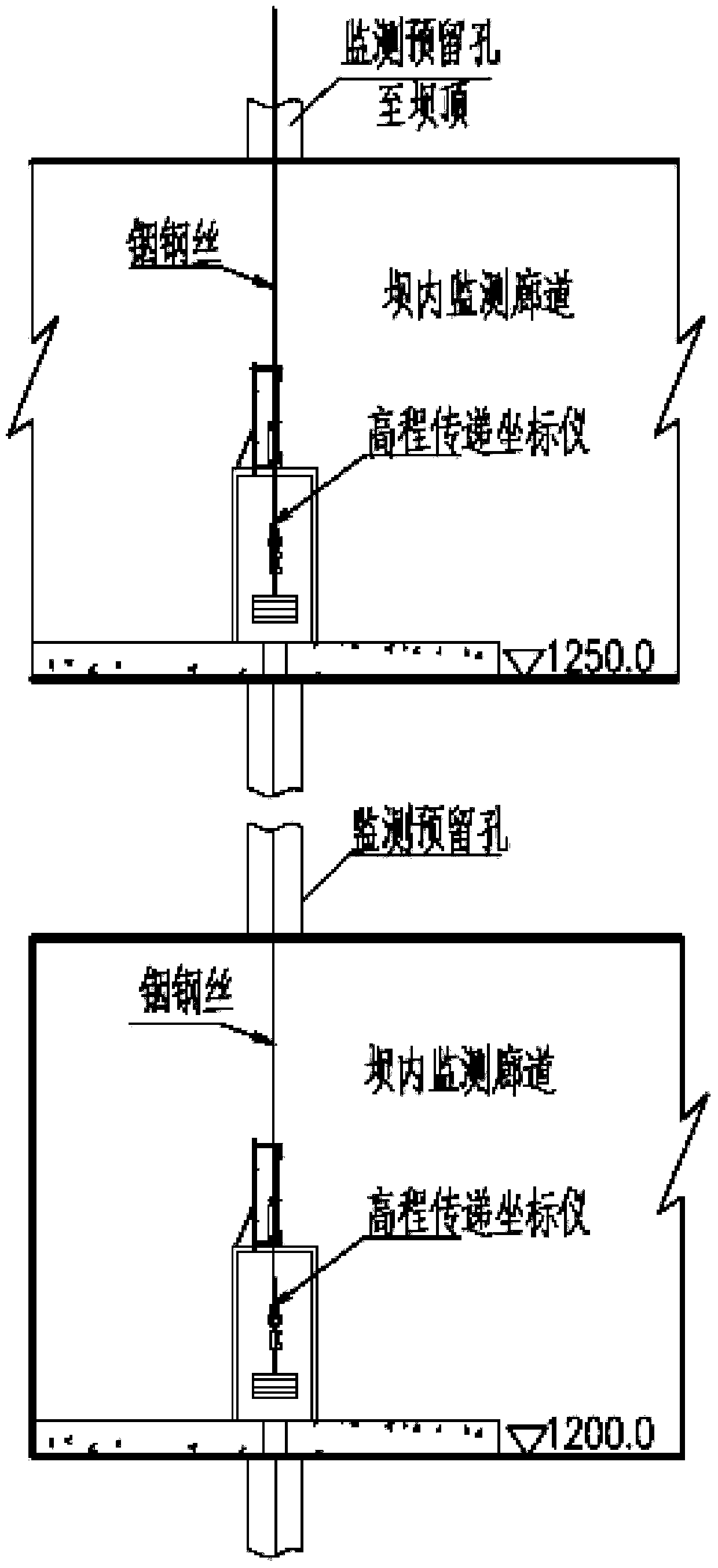
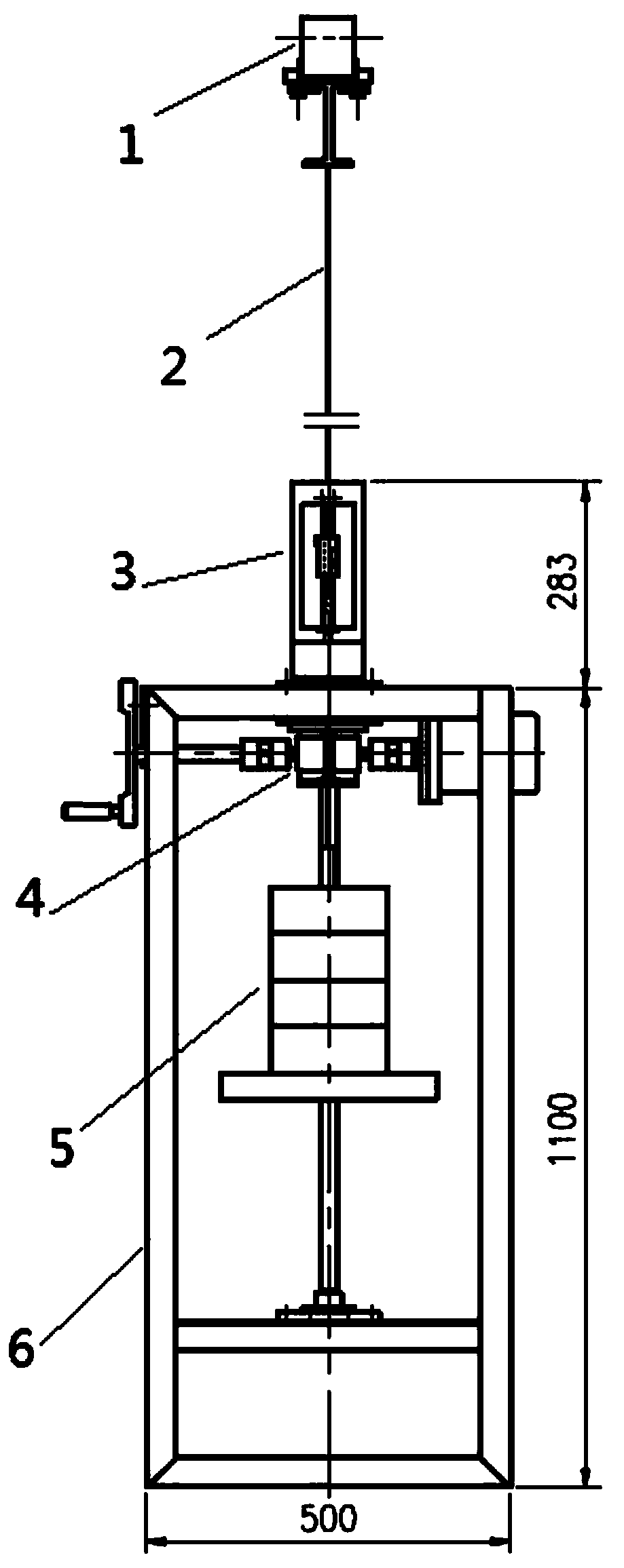
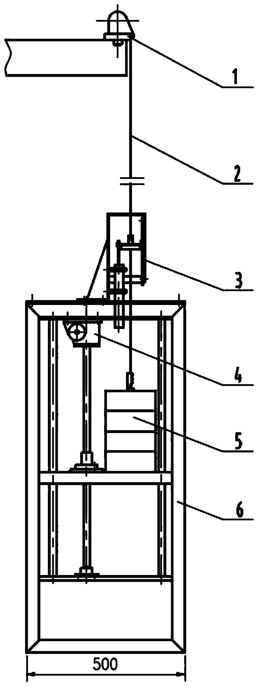
[0038] Such as figure 2 with image 3 As shown, an automatic elevation transmission coordinate instrument includes a hanging wire part 1 , a pull wire 2 , a reading part 3 , a lifting part 4 , a weight part 5 and a stand part 6 . In this embodiment, the pull wire 2 is a steel wire.

[0039] The top of the stay wire 2 is connected with the hanging wire part 1, and extends into the stand part 6 after passing through the reading part 3, and the bottom end of the stay wire 2 is connected with the weight part 5; the reading part 3 is arranged on the stand part 6, and the The component 4 is set insid...


PUM


Abstract

The invention relates to an automatic elevation transmission coordinatograph. The coordinatograph comprises a wire-hanging part (1), a stay wire (2), a reading part (3), an elevating part (4), a counterweight part (5), and a rack part (6); the top end of the stay wire (2) is connected to the wire-hanging part (1), the stay wire (2) goes through the reading part (3) and enters into the rack part (6), the bottom end of the stay wire (2) is connected to the counterweight part (5); the reading part (3) is arranged on the rack part (6), the elevating part (4) is arranged in the rack part (6); the elevating part (4) comprises a tray (406), and the counterweight part (5) is arranged above the tray (406). The coordinatograph achieves automatic control and measurement, and the measurement precision is high.

Description

technical field [0001] The invention relates to the field of elevation measurement of concrete dams, in particular to an automatic and high-precision elevation transmission measurement device. Background technique [0002] In the construction of concrete dams and the later stage of monitoring, it is an important task to measure the settlement of different elevation surfaces inside the dam, and the measurement accuracy is high and difficult. In practical applications, the elevation monitoring of concrete dams is generally carried out in the corridor inside the dam, which is different from the elevation coordinate measurement of general buildings. Due to the limitations of the space environment and the influence of factors such as large height differences, the engineering site usually uses the method of height transfer to monitor the coordinates and settlement of each height (such as figure 1 shown). Elevation transfer is a method of obtaining the elevation of the undetermin...

Claims


Application Information

Patent Timeline
Patent Type & Authority Applications(China)
IPC IPC(8): G01C5/00
CPCG01C5/00
Inventor 廖占勇刘果王甜郑水华李杰李之中
Owner NARI TECH CO LTD
Why Eureka
Try Eureka