Point cloud partition method and device

A point cloud and cluster segmentation technology, applied in the field of 3D reconstruction, can solve the problems of difficult ground and non-ground object segmentation, and achieve the effect of avoiding under-segmentation and over-segmentation.

Active Publication Date: 2014-11-12
TSINGHUA UNIV
View PDF8 Cites 63 Cited by
  • Summary
  • Abstract
  • Description
  • Claims
  • Application Information

AI Technical Summary

Problems solved by technology

However, due to the existence of ground point clouds in large outdoor scenes, it is difficult to effectively segment ground and non-ground objects using the distance-based clustering

Method used


Image

  • Point cloud partition method and device
  • Point cloud partition method and device
  • Point cloud partition method and device

Examples


Embodiment 1

[0121] Analyze data on scanlines such as Figure 5 As shown, it can be seen that the point p 1 to point p a1 , point p a4 to point p a5 is the point cloud data on the ground, point p a2 to point p a3 and point p a6 to point p n is point cloud data on non-ground objects. Combined with the analysis of most scenes, it can be obtained that on a scanning line, most point cloud data belonging to the ground exist in segments and are continuous within segments, such as Figure 5 Midpoint p 1 to point p a1 The point cloud sequence segment, point p a4 to point p a5 The point cloud sequence segment is two segments belonging to the ground; the same segment of the point cloud belongs to the ground, the local fluctuation between points is small, and the elevation difference is also small. Combined with the above analysis, in order to effectively extract the ground point cloud, the point cloud sequence segments belonging to the ground are detected column by column. In each point...

Embodiment 2

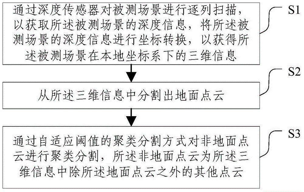
[0153] According to the ground segmentation method based on scan lines, after the ground point cloud and the non-ground point cloud are segmented, the non-ground point cloud needs to be clustered and segmented, and the point clouds belonging to different objects in the non-ground point cloud are separated from each other.

[0154] In order to avoid the phenomenon of over-segmentation and under-segmentation of clusters that may occur when using the same fixed threshold, this embodiment adopts an adaptive threshold segmentation method based on volume, that is, based on the relationship between the volume of an object and the threshold required for segmentation, Generally speaking, the distance between large-scale objects (such as buildings) is large, and the threshold value should be larger when segmenting large-volume objects, while the distance between small-volume objects (such as cars) can be smaller. Small, the threshold value should be smaller when segmenting small-volume o...

Embodiment 3

[0166] After clustering and segmenting all non-ground points in the measured scene based on the adaptive threshold radius, due to reasons such as scanning occlusion, rapid steering of the mobile platform, and irregularity of the measured object, the clustering segmentation result will have the phenomenon that the object is over-segmented , there are mainly two types of situations. One is for irregular objects such as trees. Taking trees as an example, since the trunks and branches are relatively small, they can be easily divided into multiple clusters. Among them, only the trunks are clusters on the ground. clusters, while other clusters are suspended above the ground, called suspended clusters. Another is that for large-scale objects such as buildings, due to the small threshold radius setting, when the vehicle-mounted mobile platform makes a sharp turn or scans with occlusions, the large-volume cluster will be over-segmented into multiple clusters. Therefore, it is necessary...


PUM


Abstract

The invention discloses a point cloud partition method and device, and relates to the technical field of three-dimensional reconstruction. The point cloud partition method includes the following steps: (S1) line-by-line scanning is carried out on a measured scene through a depth transducer to obtain depth information of the measured scene, and coordinate transformation is carried out on the depth information of the measured scene to obtain three-dimensional information of the measured scene under a local coordinate system; (S2) ground point clouds are partitioned from the three-dimensional information; (S3) clustering partition is carried out on non-ground point clouds in the self-adaptation threshold value clustering partition mode, wherein the non-ground point clouds are the other point clouds except the ground point clouds in the three-dimensional information. By means of the point cloud partition method and device, clustering partition is carried out on the non-ground point clouds in the self-adaptation threshold value clustering partition mode, and insufficient partition and excessive partition caused by clustering partition on the non-ground point clouds with fixed threshold values are effectively avoided.

Description

technical field [0001] The invention relates to the technical field of three-dimensional reconstruction, in particular to a point cloud segmentation method and device. Background technique [0002] The 3D reconstruction of large scenes has received great attention due to its important applications in 3D city maps, road maintenance, and urban planning. The use of depth sensors and position and attitude sensors to collect 3D information of the surrounding environment based on fixed stations or mobile platforms is widely used due to its high efficiency, real-time, and high-precision characteristics. Since the scanned scene contains different types of objects, such as the ground, buildings, trees, vehicles, etc., before performing 3D reconstruction, it is necessary to separate the point cloud data corresponding to different types of objects from each other through point cloud segmentation, so that each object Point cloud modeling is performed separately. [0003] Most of the c...

Claims


Application Information

Patent Timeline
IPC IPC(8): G06T7/00
Inventor 朱晓鑫周莹谢翔王丹李国林唐维俊王志华
Owner TSINGHUA UNIV
Why Eureka
Try Eureka