Parallel Segmentation Method of Remote Sensing Image Based on Superpixel

A remote sensing image and super-pixel technology, applied in image analysis, image enhancement, image data processing, etc., can solve the problems of large space occupation and time consumption, and achieve the effect of increasing segmentation speed, ensuring segmentation accuracy, and improving adaptability

Active Publication Date: 2022-05-10
XIDIAN UNIV
View PDF10 Cites 0 Cited by
  • Summary
  • Abstract
  • Description
  • Claims
  • Application Information

AI Technical Summary

Problems solved by technology

[0005] Aiming at the deficiencies of the prior art, the present invention proposes a fast, accurate and easy-to-implement engineering remote sensing image parallel segmentation method, aiming to solve the problems of traditional serial segmentation that consume a lot of time and occupy a large space

Method used


Image

  • Parallel Segmentation Method of Remote Sensing Image Based on Superpixel
  • Parallel Segmentation Method of Remote Sensing Image Based on Superpixel
  • Parallel Segmentation Method of Remote Sensing Image Based on Superpixel

Examples


Embodiment Construction

[0050] The present invention will be described in further detail below in conjunction with specific examples, but the embodiments of the present invention are not limited thereto.

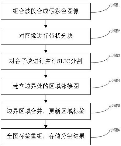
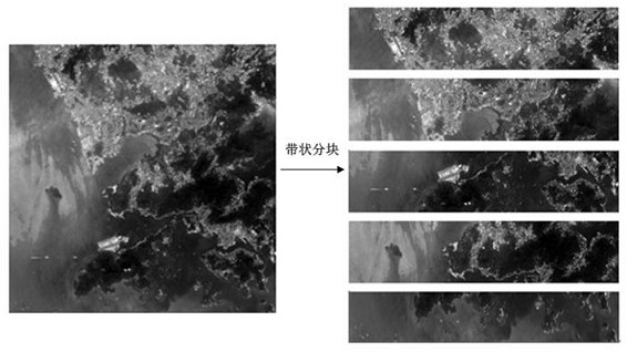
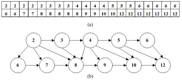
[0051] Aiming at the limitations of traditional algorithms, the present invention proposes a parallel segmentation method based on superpixels. The goal is to generate uniform superpixels with precise boundaries and high speed, and can be applied to super-large-size images. First, analyze the multi-band information of the remote sensing image, improve the traditional three-band combination, and select the four-band combination with the maximum image entropy to generate a false color image; then, divide the generated image into bands, and use multi-core computer and OpenMPI (Open Multi-Processing) Based on the advantages, the SLIC parallel segmentation process is performed in blocks; the region merging algorithm is designed to determine the adjacency relationship of the parallel segmentation results,...


PUM


Abstract

The invention relates to a method for parallel segmentation of remote sensing images based on superpixels, which includes combining bands to synthesize false-color images, performing banded block segmentation on false-color images, performing parallel SLIC segmentation on each sub-block, establishing a region adjacency graph at the boundary, There are six steps for merging boundary regions, updating region labels, reorganizing full image labels, and storing segmentation results; the present invention integrates false color image generation, parallel segmentation, regional heterogeneity evaluation, boundary merging processing, run-length code compression storage, etc. technology, which not only ensures the accuracy of the segmentation edge, but also improves the segmentation speed, which is beneficial to the engineering application of the algorithm.

Description

technical field [0001] The invention belongs to the technical field of remote sensing image segmentation, relates to the processing of remote sensing data information and the segmentation of digital images, in particular to a method for area segmentation of remote sensing images captured by surveying and mapping satellites. Background technique [0002] With the rapid development of aerospace science, revolutionary changes have taken place in the photography and surveying technology of the earth. Remote sensing images are widely used in town planning, environmental protection, geological exploration, disaster assessment and military fields because of their good time phase, rich information and continuously improving resolution. Remote sensing image segmentation is an important prerequisite for quantitative evaluation of the actual image area, and the quality of its segmentation directly affects the accuracy of subsequent analysis, recognition, and interpretation. Remote sen...

Claims


Application Information

Patent Timeline
Patent Type & Authority Patents(China)
IPC IPC(8): G06T7/13G06T7/187
CPCG06T7/13G06T7/187G06T2207/10024G06T2207/10032G06T2207/20021
Inventor 朱娟娟张恩泽刘硕珣赵阳郭彦宗朱倩蓓
Owner XIDIAN UNIV
Why Eureka
Try Eureka