Elevation value-based 3D barrier method and device for remote sensor automatic safety area screening

A technology of safe area and automatic screening, applied in the field of remote sensing image processing, can solve the problems of large influence of light, complex algorithm, large amount of calculation, etc., and achieve the effect of short time, low calculation cost and high speed.

Active Publication Date: 2015-02-18
NANJING UNIV OF SCI & TECH
View PDF3 Cites 5 Cited by
  • Summary
  • Abstract
  • Description
  • Claims
  • Application Information

AI Technical Summary

Problems solved by technology

Many references have been introduced for the detection of slopes; while the crater has a relatively regular geometric shape, Bertrand Leroy et al. proposed an algorithm based on edge detection to fit the shape of the crater with an ellipse, but this method is not applicable to the situation where multiple craters overlap ; For the detection of rocks, Ma et al. proposed the edge optical flow algorithm, which is based on texture image segmentation, and the light has a greater impact; Gor et al. proposed an algorithm based on Gaborfilter, but the algorithm is complex and the amount of calculation is large

Method used


Image

  • Elevation value-based 3D barrier method and device for remote sensor automatic safety area screening

Examples


Embodiment Construction

[0035] In order to better understand the technical content of the present invention, specific embodiments are given together with the attached drawings for description as follows.

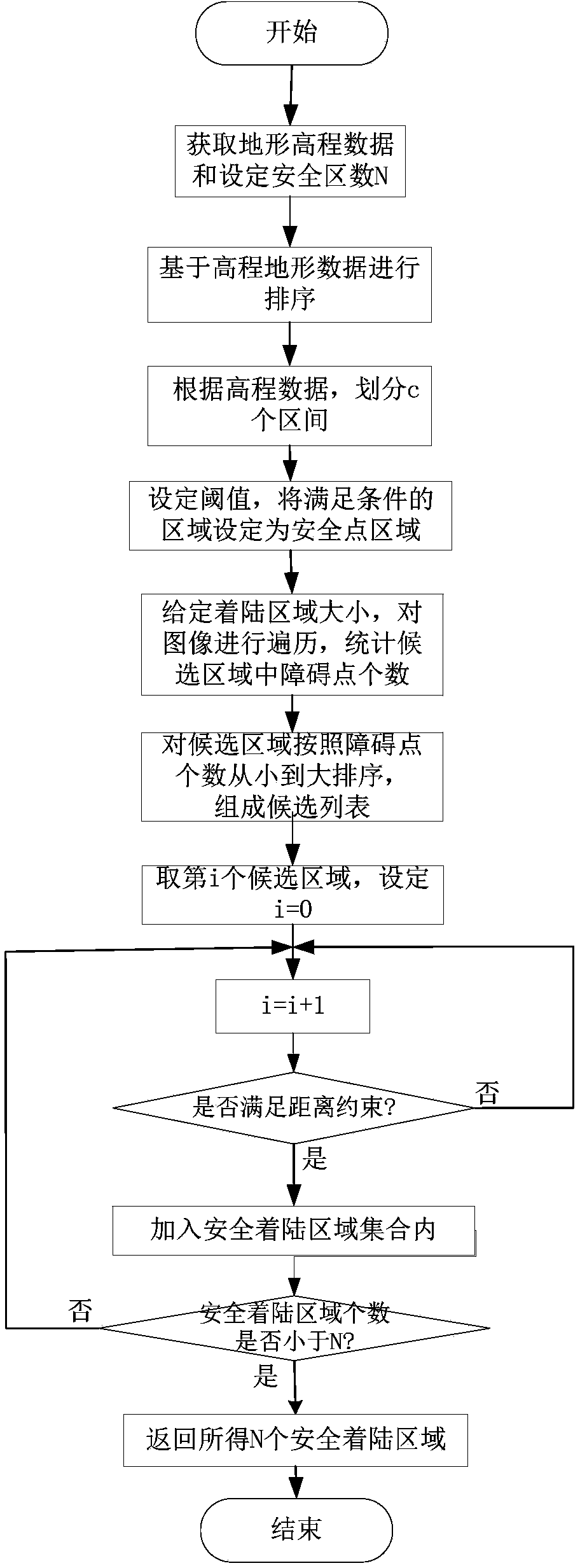
[0036] The 3D barrier method based on the elevation value of the remote sensor to automatically screen the safe area proposed in this embodiment, analyzes the characteristics of the 3D terrain data and counts the elevation value of the 3D terrain data by the remote sensor on-orbit, and estimates the safe landing candidate area in the image , and sort the candidate areas by counting the number of obstacle points and increasing the distance constraints between the candidate areas to get the final optimal safe landing area.

[0037] like figure 1 As shown, according to a preferred embodiment of the present invention, the remote sensor based on the elevation value automatically screens the 3D barrier method of the safe area, and its realization includes the following steps:

[0038] Step 1. For a land...


PUM


Abstract

The invention provides an elevation value-based 3D barrier method for remote sensor automatic safety area screening. The method includes: a remote sensor analyzes 3D terrain data features in an on-orbit manner and statistically count the elevation value of the 3D terrain data so as to estimate safety landing candidate areas in an image, and sorting the candidate areas by statistically counting barrier points, and increasing the distance constraint among the candidate areas so as to obtain the final optimal safety landing area. The method has the advantages that remote sensing image safety point and barrier point judging based on the elevation value is adopted, and real-time selecting of the safety areas is achieved; by the method which is low in operation cost and fast and can satisfy the requirement of short landing time of a landing device, safety landing areas can be timely selected by using 3D image information. The invention further relates a 3D barrier device for remote sensor automatic safety area screening.

Description

technical field [0001] The invention relates to a method for instructing remote sensors to automatically screen safe areas on orbit, in particular to judging safe points and obstacle points of remote sensing images based on elevation values, and belongs to the technical field of remote sensing image processing. Background technique [0002] The choice of the landing site of the probe is directly related to whether the probe can land safely. Sampling and return of probes on target celestial bodies such as Mars and asteroids is a hotspot in deep space exploration at present and in the future. After the failure of the Mars Polar Lander (MPL) mission, researchers have once again paid high attention to the robustness of the landing obstacle avoidance system. The selection of the landing area is usually selected by the ground system based on the pictures taken by the detector, comprehensive safety, fuel consumption and scientific exploration value, and safety is the most importan...

Claims


Application Information

Patent Timeline
Patent Type & Authority Applications(China)
IPC IPC(8): G06T7/00
CPCG06T2207/10032
Inventor 孙权森王立沈肖波季鸿坤牛四杰
Owner NANJING UNIV OF SCI & TECH
Why Eureka
Try Eureka