Automatic waste empty house site information extraction method based on remote-sensing image

A remote sensing image and information extraction technology, applied to instruments, character and pattern recognition, computer components, etc., can solve problems such as misjudgment of empty and abandoned homesteads, low accuracy of results, and difficulty in realizing full automation

Active Publication Date: 2015-03-25
INST OF GEOGRAPHICAL SCI & NATURAL RESOURCE RES CAS
View PDF2 Cites 11 Cited by
  • Summary
  • Abstract
  • Description
  • Claims
  • Application Information

AI Technical Summary

Problems solved by technology

However, the existing object-oriented methods often ignore the use of existing high-precision data, so that the accuracy of the information extraction results is low, and there is a large discrepancy with the existing data
In addition, in the existing object-oriented methods, the spectral, shape, and texture features of the object are mostly used in the object classification and recognition, and the contextual features are ignored.
For example, the judgment of an empty and abandoned homestead only uses the cha

Method used


Image

  • Automatic waste empty house site information extraction method based on remote-sensing image
  • Automatic waste empty house site information extraction method based on remote-sensing image
  • Automatic waste empty house site information extraction method based on remote-sensing image

Examples


Embodiment Construction

[0046] The method for extracting empty and abandoned homestead information of the present invention will be described in detail below in conjunction with specific embodiments.

[0047] In this embodiment, the effect used is a high-resolution remote sensing image. In order to be able to clearly extract the characteristics of the house courtyard, the resolution of the high-resolution remote sensing images used should be within 0.5 meters, and the accuracy of the cadastral data should be within this range.

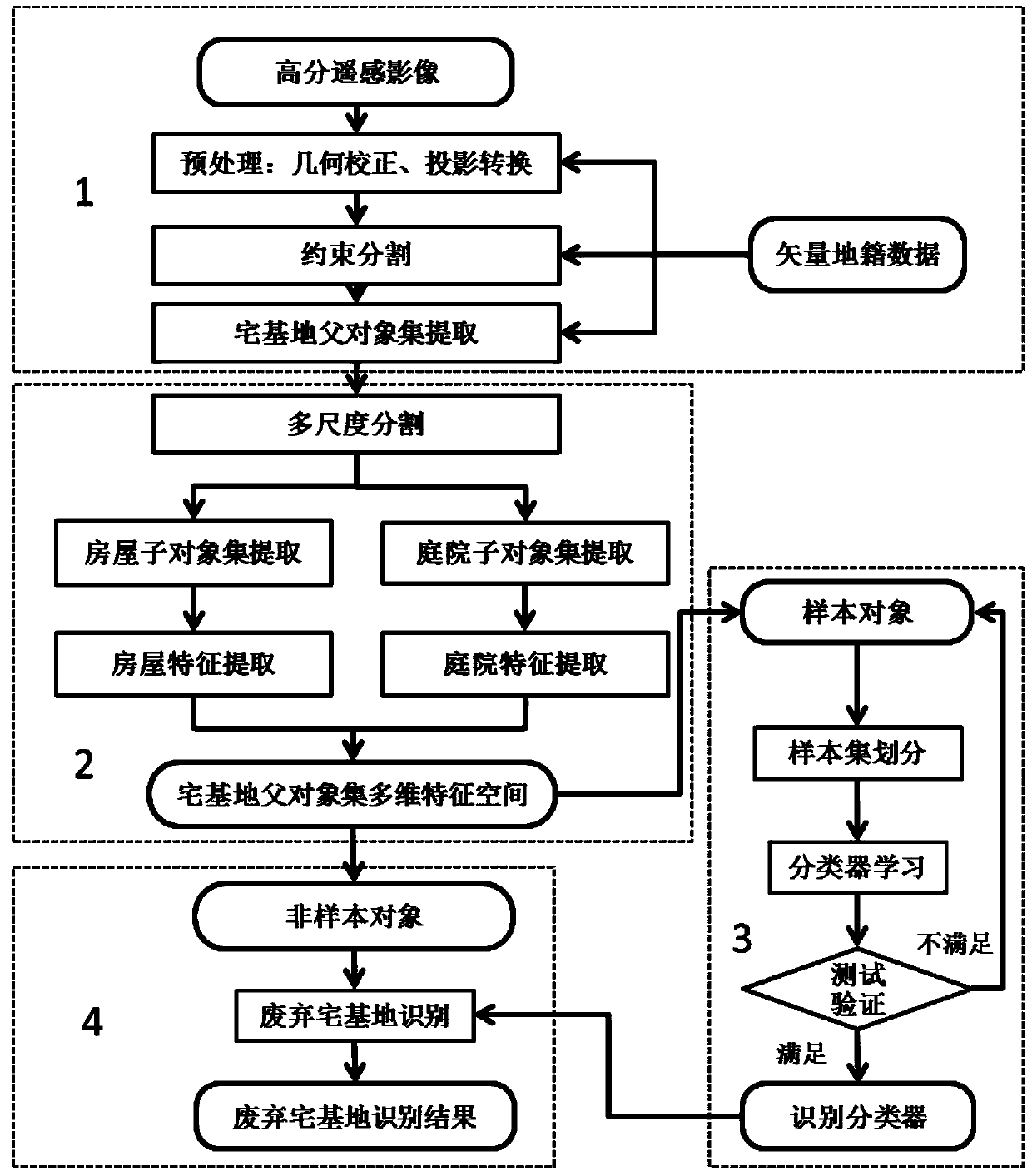
[0048] Such as figure 1 As shown, the empty and waste homestead extraction method in the present embodiment is mainly divided into the following four main parts:

[0049] (1) Homestead object extraction, which includes the following three sub-steps:

[0050] M1S 1 data preprocessing, that is, geometric correction of high-resolution images, and projection transformation based on the vector cadastral data projection space. Satellite remote sensing images, aerial remote sensi...


PUM


Abstract

The invention provides an automatic waste empty house site information extraction method based on a remote-sensing image. According to the method, the high-resolution remote sensing image is partitioned through vector cadastre data constraint, a method that the contextual feature of a multi-dimensional space structure serves as the recognition feature of a waste empty house site, and a method that classified recognition conducted through a classifier is adopted, the recognition accuracy of the waste empty house site is effectively improved, and automated extraction of the waste empty house site is achieved. The method mainly includes the steps that (1) the high-resolution remote sensing image and the vector cadastre data of the region to be extracted of the waste empty house site are obtained, the high-resolution remote sensing image is partitioned through the vector cadastre data constraint, and a house site object is extracted; (2) the house site object serves as the father object, partition is conducted continuously, and internal sub objects of the house site and related house and courtyard features of the waste empty house site are extracted to form a multi-dimensional feature space; (3) samples and the classifier are selected to conduct training study of the classifier; (4) by the adoption of the method of classified recognition conducted through the classifier is adopted, a waste empty house site plaque is recognized, and the recognition result is output.

Description

technical field [0001] The invention relates to the technical field of remote sensing image information extraction, in particular to a method for automatically extracting rural empty and abandoned homestead information based on remote sensing images. Background technique [0002] In the process of rapid industrialization and urbanization in China, due to the imperfect management system of rural homesteads, the problems of inefficient utilization such as "one household with multiple houses", excessive occupation of homesteads, vacant and abandoned homesteads in rural areas are more prominent. This problem is exacerbated by the rapid advancement of globalization. According to the national census data, my country’s rural population peaked at 860 million in 1995, and decreased to 670 million by 2010. It is estimated that more than 100 million farmers will move to cities by 2020, and more than 300 million rural population will “leave villages and enter cities” by then If the exis...

Claims


Application Information

Patent Timeline
IPC IPC(8): G06K9/46G06K9/62G06K9/66
CPCG06V10/44G06F18/2413
Inventor 刘彦随杨晓梅王介勇王志华陈玉福
Owner INST OF GEOGRAPHICAL SCI & NATURAL RESOURCE RES CAS
Why Eureka
Try Eureka