A Method of Rural Residential Land Use Based on Active and Passive Remote Sensing Data

A technology of remote sensing data and extraction method, which is applied in the field of remote sensing image processing, can solve problems such as mixing and distinguishing, and achieve the effect of improving accuracy

Inactive Publication Date: 2018-10-09
BEIJING NORMAL UNIVERSITY
View PDF4 Cites 0 Cited by
  • Summary
  • Abstract
  • Description
  • Claims
  • Application Information

AI Technical Summary

Problems solved by technology

Existing studies still have some deficiencies in the extraction of rural residential land: in medium-resolution optical images, the unused land and fallow bare land around rural residential areas have similar spectra to the residential land, resulting in the confusion of different objects with the same spectrum. Minute
From the perspective of scattering mechanism, POLSAR images can accurately distinguish between bare land and rural residential land, but it is difficult to distinguish rural residential land from surrounding forest land during extraction due to the low height of rural residential areas

Method used


Image

  • A Method of Rural Residential Land Use Based on Active and Passive Remote Sensing Data
  • A Method of Rural Residential Land Use Based on Active and Passive Remote Sensing Data
  • A Method of Rural Residential Land Use Based on Active and Passive Remote Sensing Data

Examples


Embodiment Construction

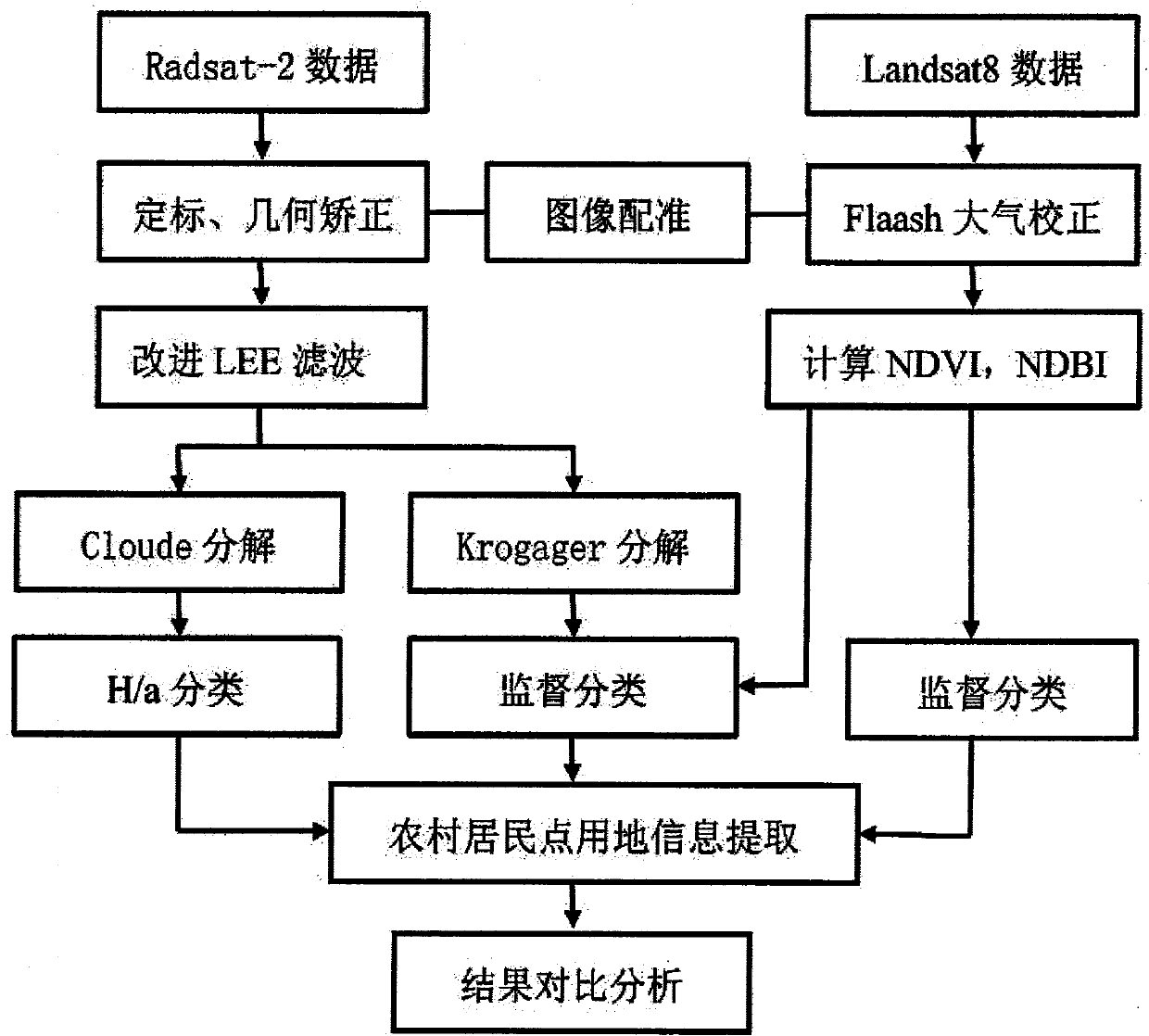
[0036] The present invention will be further elaborated below in conjunction with the accompanying drawings and embodiments.
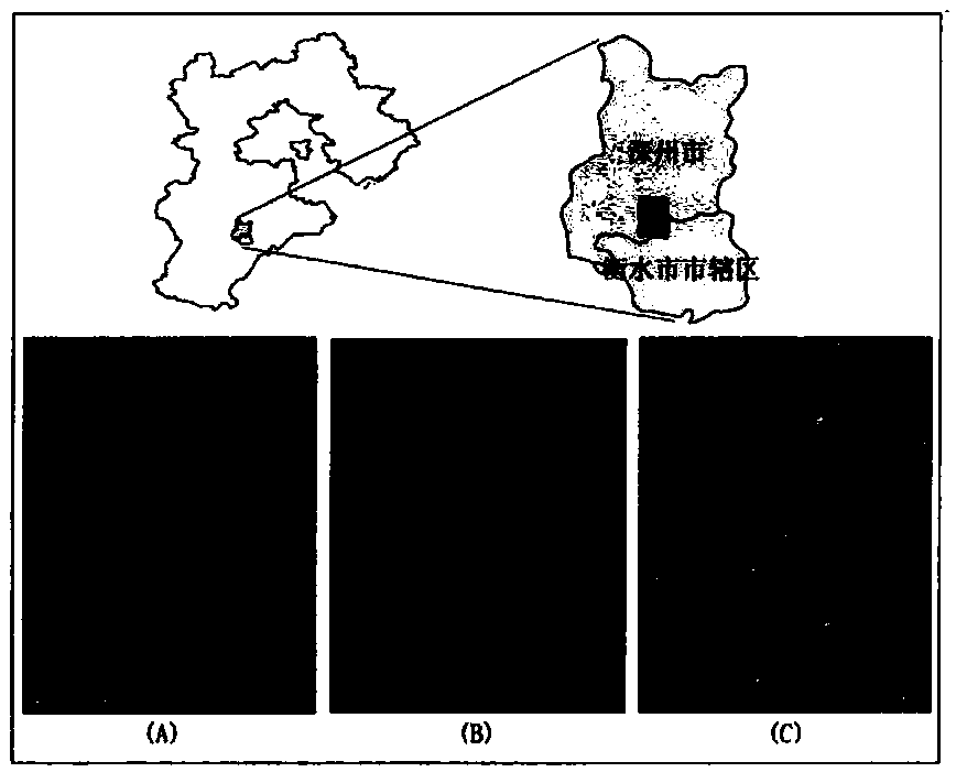
[0037] The research area of ​​the present invention is located at the junction of Taocheng District and Shenzhou City, Hengshui City, Hebei Province, and the range of 10km * 10km is selected as figure 2 As shown, the land use types cover cultivated land, water body, forest land, unused land, and urban and rural, industrial and mining land, and residential land. Among them, urban and rural, industrial and mining land, and residential land are mainly rural residential areas, and the cultivated land crops are mainly winter wheat and summer corn. figure 2 (A) In the distribution map of rural residential areas, the rural residential areas are loosely distributed and of different sizes. Through the visual interpretation of the high-resolution images, the study area contains a total of 38 rural residential areas. The data used in the research is the OLI ima...


PUM


Abstract

The invention discloses a method for extracting rural settlement land based on active and passive remote sensing data, comprising the following steps: (1) acquiring data and preprocessing; (2) calculating normalized vegetation index; (3) normalized building index Calculation; (4) Calculation of POLSAR dihedral scattering component; 5) Maximum likelihood classification. The present invention comprehensively applies optical remote sensing and microwave remote sensing information, and the complementary advantages of the two can more fully reflect the differences among ground features, and greatly improve the accuracy of extracting land for rural settlements.

Description

technical field [0001] The invention relates to remote sensing image processing technology, in particular to a method for extracting land for rural residential areas based on active and passive remote sensing data. Background technique [0002] Extracting the land use distribution and construction scale of rural residential areas is of great significance for saving cultivated land, rationally developing and utilizing land resources, improving rural ecological environment, promoting urbanization development, and building new countryside. Remote sensing technology is based on physical means, mathematical methods and geographical analysis. It is a comprehensive application technology that can identify and extract surface information macroscopically, dynamically and quickly. Using remote sensing technology to extract information on urban and rural residential areas and building land has been extensively studied at home and abroad. The land used for rural settlements is small in...

Claims


Application Information

Patent Timeline
Patent Type & Authority Patents(China)
IPC IPC(8): G06K9/46G06K9/62
CPCG06V20/176G06V10/462G06F18/24
Inventor 李天祺朱秀芳潘耀忠
Owner BEIJING NORMAL UNIVERSITY
Why Eureka
Try Eureka