Remote Sensing Image Segmentation Method Using Region Splitting Technology

A technology of remote sensing image and area, applied in image analysis, image enhancement, image data processing, etc.

Active Publication Date: 2016-03-02
HEFEI UNIV OF TECH
View PDF3 Cites 0 Cited by
  • Summary
  • Abstract
  • Description
  • Claims
  • Application Information

AI Technical Summary

Problems solved by technology

[0005] The purpose of the present invention is to provide a remote sensing image segmentation method using region splitting technology to solve the shortcomings of the existing technology, and to adaptively adjust the scale in the corresponding spatial context model according to the scale of objects in different regions in the scene Weights, fully consider the impact of different scale areas on the spatial context model, so as to improve the segmentation accuracy of remote sensing images in complex scenes

Method used


Image

  • Remote Sensing Image Segmentation Method Using Region Splitting Technology
  • Remote Sensing Image Segmentation Method Using Region Splitting Technology
  • Remote Sensing Image Segmentation Method Using Region Splitting Technology

Examples


specific Embodiment

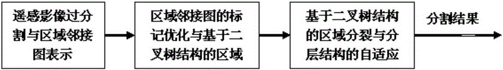
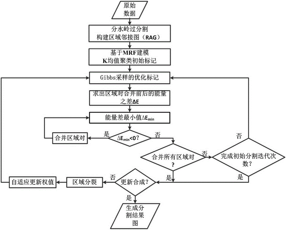
[0057] In this embodiment, digital image processing technology is used to accurately segment remote sensing images of complex scenes. Its invention process is as follows:

[0058] refer to figure 1 Firstly, remote sensing image over-segmentation and region adjacency graph representation are carried out. refer to figure 2 Watershed over-segmentation is performed on the input remote sensing image, resulting in many small regions, each with relatively consistent backscatter values. Each region R consists of a set of positions S R composition, these locations belong to the region. The feature vector {Y of each position S |s∈S R} averaged to an eigenvector Y R . And use a specific data structure Region Adjacency Graph (RAG) to describe the image. The nodes of the adjacency graph are composed of a group of regions R, and its edges represent the boundary positions between each pair of adjacent regions.

[0059] refer to figure 1 Mark optimization of region adjacency graph ...


PUM


Abstract

The invention discloses a remote sensing image segmentation method adopting a region splitting technology. The method comprises the following steps: firstly, an image is subjected to initial segmentation with a watershed segmentation algorithm, and image regionalization is realized; a region adjacency graph is established for the regionalized image; the region adjacency graph is modeled based on the Markov field and is subjected to k-means initial marking; a iteration part is started, the initially marked image is subjected to Gibbs sampling marker optimization and initial region merging based on a global iteration weight of a Markov model, and record of a merging process is protected in a binary tree mode simultaneously; then the initial segmentation image is subjected to region splitting, and returning to initial regionalization configuration is performed; according to the positive correlation between the node number of a binary tree structure of a region and dimension of an object in a scene, the dimension weight in each regional space context model is adjusted adaptively, region markers are updated, and a final segmentation result is obtained. The noise influence can be eliminated very well, and adaptive marker updating in complicated scene of the image can be realized.

Description

technical field [0001] The invention relates to the field of remote sensing image segmentation methods, in particular to a remote sensing image segmentation method using region splitting technology. Background technique [0002] Image segmentation is an important part of the application of automatic image interpretation. Among them, the operational application of automatic interpretation of remote sensing images is of great significance in ship navigation and climate research. Remote sensing images have the characteristics of high definition and large amount of information. Among them, synthetic aperture radar also has the characteristics of all-day and all-weather. Now it has been widely used in various fields such as environmental monitoring and military affairs. However, the imaging process of remote sensing images will be affected by various factors, such as the characteristics of the imaging system (in which the incident angle and coherent speckle noise have a greater i...

Claims


Application Information

Patent Timeline
Patent Type & Authority Patents(China)
IPC IPC(8): G06T7/00
CPCG06T7/11G06T2207/10032G06T2207/20081
Inventor 郎文辉昂安杨学志贾尚柱
Owner HEFEI UNIV OF TECH
Why Eureka
Try Eureka